mail_outline sales@mediastorehouse.com
389 items
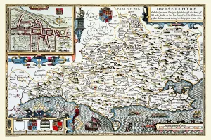
Old County Map of Dorsetshire 1611 by John SpeedA facimile of John Speeds historical map of Dorsetshire originally published for the " Theatre of the Empire of Great Britain", an atlas to accompany " a history of Great Britain"
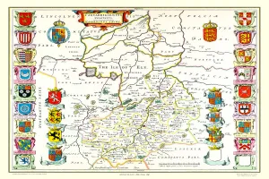
Old County Map of Cambridgeshire 1648 by Johan Blaeu from the Atlas NovusThis detailed and most attractive reproduction map of Cambridgeshire has been carefully art worked from a scan of an antique original
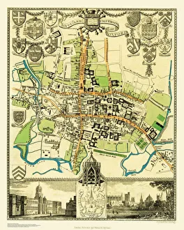
Old Map of the City Oxford 1836 by Thomas MouleThis is a fine decorative reproduction Map of The City of Oxford from the First Edition series of Thomas Moule Maps, originally Published in 1836
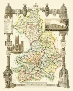
Old County Map of Cambridgeshire 1836 by Thomas MouleThis is a fine decorative reproduction County Map of Cambridgeshire from the First Edition series of Thomas Moule Maps, originally Published in 1836
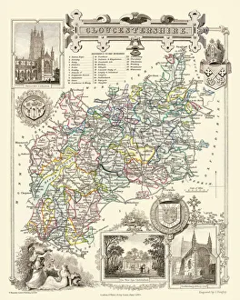
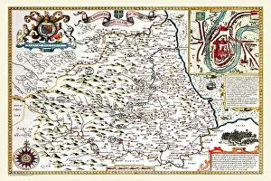
Old County Map of Gloucestershire 1836 by Thomas MouleThis is a fine decorative reproduction County Map of Gloucestershire from the First Edition series of Thomas Moule Maps, originally Published in 1836
Old County Map of Berkshire 1836 by Thomas MouleThis is a fine decorative reproduction County Map of Berkshire from the First Edition series of Thomas Moule Maps, originally Published in 1836
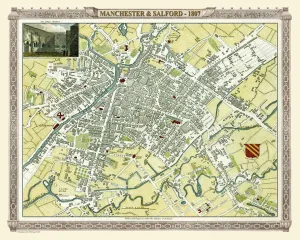
Old Map of Manchester 1807 by Cole and RoperAn attractive and detailed early 19th century reproduction town plan of Manchester 1807. First published by Cole and Roper as a finely engraved series of county maps
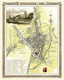
Old Map of Worcester 1808 by Cole and RoperAn attractive and detailed early 19th century reproduction town plan of Worcester 1808. First published by Cole and Roper as a finely engraved series of county maps
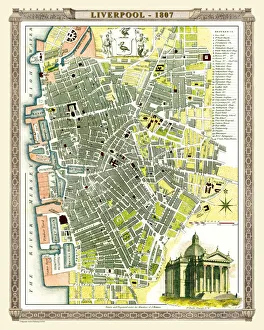
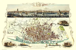
Old Map of Liverpool 1807 by Cole and RoperAn attractive and detailed early 19th century reproduction town plan of Liverpool 1807. First published by Cole and Roper as a finely engraved series of county maps
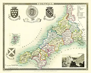
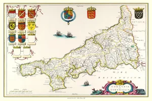
Old County Map of Cornwall 1836 by Thomas MouleThis is a fine decorative reproduction County Map of Cornwall from the First Edition series of Thomas Moule Maps, originally Published in 1836
Old Map of the Environs of Bath and Bristol 1836 by Thomas MouleThis is a fine decorative reproduction Map of The Environs of Bath and Bristol from the First Edition series of Thomas Moule Maps, originally Published in 1836
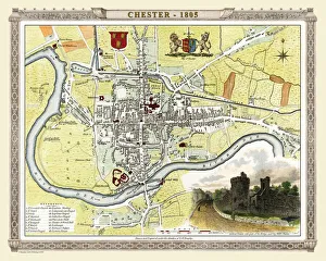
Old Map of Chester 1805 by Cole and RoperAn attractive and detailed early 19th century reproduction town plan of Chester 1805. First published by Cole and Roper as a finely engraved series of county maps
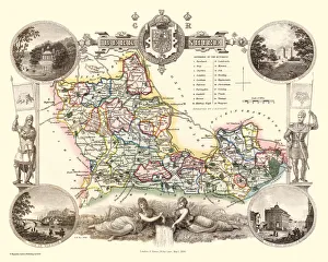
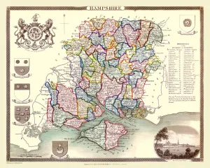
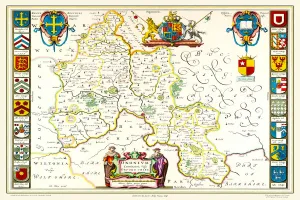
Old County Map of Hampshire 1836 by Thomas MouleThis is a fine decorative reproduction County Map of Hampshire from the First Edition series of Thomas Moule Maps, originally Published in 1836
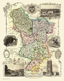
Old County Map of Derbyshire 1836 by Thomas MouleThis is a fine decorative reproduction County Map of Derbyshire from the First Edition series of Thomas Moule Maps, originally Published in 1836
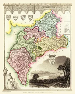
Old County Map of Cumberland 1836 by Thomas MouleThis is a fine decorative reproduction County Map of Cumberland from the First Edition series of Thomas Moule Maps, originally Published in 1836
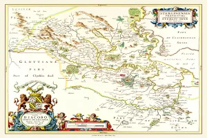
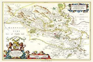
Old County Map of Sterlingshire 1654 by Johan Blaue from the Atlas NovusThis detailed and most attractive reproduction map of Sterlingshire, Scotland, has been carefully art worked from a scan of an antique original
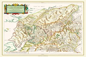
Old Map of Teviotdale Scotland 1654 from the Atlas NovusThis detailed and most attractive reproduction map of Teviotdale, Scotland, has been carefully art worked from a scan of an antique original
Old County Map of Oxfordshire 1648 by Johan Blaeu from the Atlas NovusThis detailed and most attractive reproduction map of Oxfordshire has been carefully art worked from a scan of an antique original
Old County Map of Northumberland 1611 by John SpeedA facimile of John Speeds historical map of Northumberland originally published for the " Theatre of the Empire of Great Britain"
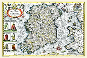
Old Map of Ireland 1611 by John SpeedA facimile of John Speeds historical map of Ireland originally published for the " Theatre of the Empire of Great Britain", an atlas to accompany " a history of Great Britain"
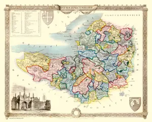
Old County Map of Somersetshire 1836 by Thomas MouleThis is a fine decorative reproduction County Map of Somersetshire from the First Edition series of Thomas Moule Maps, originally Published in 1836
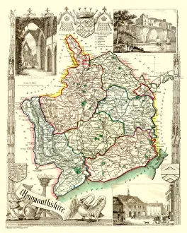
Old County Map of Monmouthshire 1836 by Thomas MouleThis is a fine decorative reproduction County Map of Monmouthshire from the First Edition series of Thomas Moule Maps, originally Published in 1836
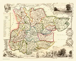
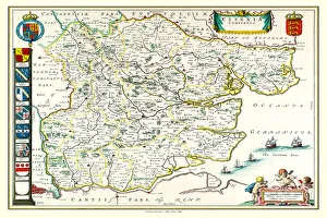
Old County Map of Essex 1836 by Thomas MouleThis is a fine decorative reproduction County Map of Essex from the First Edition series of Thomas Moule Maps, originally Published in 1836
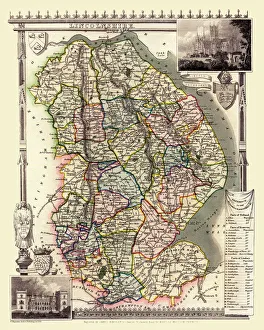
Old County Map of Lincolnshire 1836 by Thomas MouleThis is a fine decorative reproduction County Map of Lincolnshire from the First Edition series of Thomas Moule Maps, originally Published in 1836
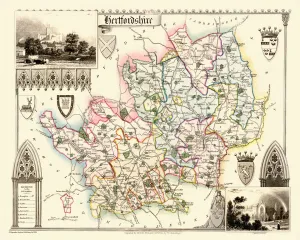
Old County Map of Hertfordshire 1836 by Thomas MouleThis is a fine decorative reproduction County Map of Hertfordshire from the First Edition series of Thomas Moule Maps, originally Published in 1836
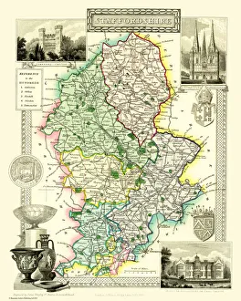
Old County Map of Staffordshire 1836 by Thomas MouleThis is a fine decorative reproduction County Map of Staffordshire from the First Edition series of Thomas Moule Maps, originally Published in 1836
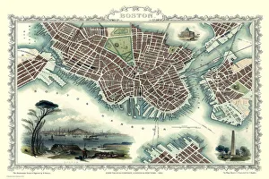
Old Map of Boston United States of America 1851 by John TallisThis a most attractive plan of Boston by John Tallis 1851 that includes South Boston Bay, part of South Boston with Charleston Town to the right of the plan
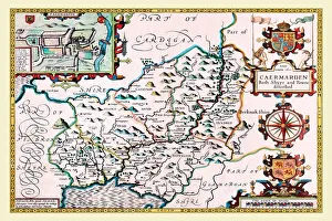
Old County Map of Carmarthenshire 1611 by John SpeedA facimile of John Speeds historical map of Carmarthenshire originally published for the " Theatre of the Empire of Great Britain"
Old Map of Liverpool 1851 by John TallisRunning along the entire length of the plan of Liverpool in Lancashire by John Tallis 1851 is a most attractive view across the River Mersey from Birkenhead to the Victorian Liverpool skyline
Old County Map of Durham 1648 by Johan Blaeu from the Atlas NovusThis detailed and most attractive reproduction map of Durham has been carefully art worked from a scan of an antique original
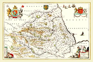
Old County Map of Yorkshire 1648 by Johan Blaeu from the Atlas NovusThis detailed and most attractive reproduction map of Yorkshire has been carefully art worked from a scan of an antique original
Old County Map of Inverness-shire 1654 by Johan Blaeu from the Atlas NovusThis detailed and most attractive reproduction map of Inverness-shire has been carefully art worked from a scan of an antique original
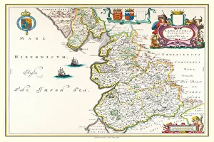
Old County Map of Lancashire 1648 by Johan Blaeu from the Atlas NovusThis detailed and most attractive reproduction map of Lancashire has been carefully art worked from a scan of an antique original
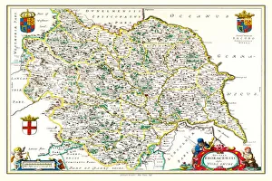
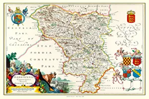
Old County Map of Derbyshire 1648 by Johan Blaeu from the Atlas NovusThis detailed and most attractive reproduction map of Derbyshire has been carefully art worked from a scan of an antique original
Old County Map of Cornwall 1648 by Johan Blaeu from the Atlas NovusThis detailed and most attractive reproduction map of Cornwall has been carefully art worked from a scan of an antique original
Old County Map of Essex 1648 by Johan Blaeu from the Atlas NovusThis detailed and most attractive reproduction map of Essex has been carefully art worked from a scan of an antique original
Old County Map of Hampshire 1648 by Johan Blaeu from the Atlas NovusThis detailed and most attractive reproduction map of Hampshire has been carefully art worked from a scan of an antique original
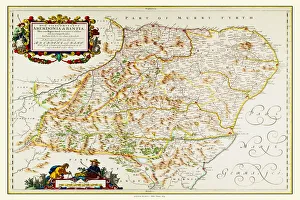
Old County Map of Aberdeen and Banff 1654 by Johan Blaeu from the Atlas NovusThis detailed and most attractive reproduction map of Aberdeen and Banff has been carefully art worked from a scan of an antique original
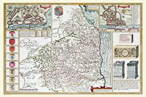
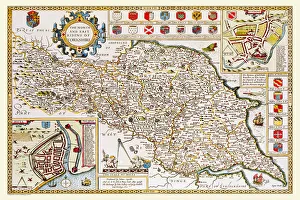
Old County Map of Yorkshire North and East Riding 1611 by John SpeedA facimile of John Speeds historical map of Yorkshire North and East Riding originally published for the " Theatre of the Empire of Great Britain"
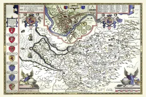
Old County Map of Cheshire 1611 by John SpeedA facimile of John Speeds historical map of Cheshire originally published for the " Theatre of the Empire of Great Britain", an atlas to accompany " a history of Great Britain"
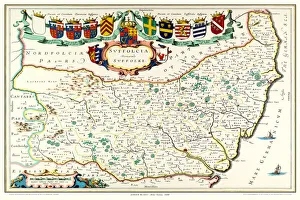
Old County Map of Suffolk 1648 by Johan Blaeu from the Atlas NovusThis detailed and most attractive reproduction map of Suffolk has been carefully art worked from a scan of an antique original
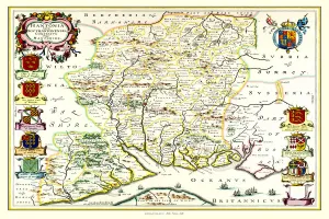
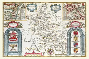
Old County Map of Buckinghamshire 1611 by John SpeedA fine reproduction of John Speeds historical map of Buckinghamshire originally published for the " Theatre of the Empire of Great Britain"
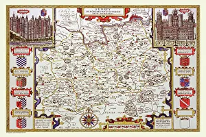
Old County Map of Sussex 1611 by John SpeedA facimile of John Speeds historical map of Sussex originally published for the " Theatre of the Empire of Great Britain", an atlas to accompany " a history of Great Britain"
Old County Map of Durham 1611 by John SpeedA facimile of John Speeds historical map of Durham originally published for the " Theatre of the Empire of Great Britain", an atlas to accompany " a history of Great Britain"
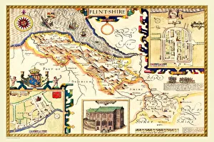
Old County Map of Flintshire 1611 by John SpeedA facimile of John Speeds historical map of Flintshire originally published for the " Theatre of the Empire of Great Britain", an atlas to accompany " a history of Great Britain"
Old Map of The Province of Leinster, Ireland 1611 by John SpeedA facimile of John Speeds historical map of the Province of Leinster originally published for the " Theatre of the Empire of Great Britain"
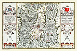
Old Map of The Isle of Man 1611 by John SpeedA facimile of John Speeds historical map of the Isle of Man originally published for the " Theatre of the Empire of Great Britain"
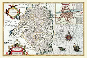
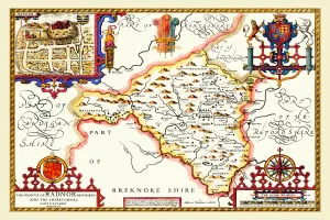
Old County Map of Radnorshire, Wales 1611 by John SpeedA facimile of John Speeds historical map of Radnorshire originally published for the " Theatre of the Empire of Great Britain", an atlas to accompany " a history of Great Britain"