mail_outline sales@mediastorehouse.com
183 items
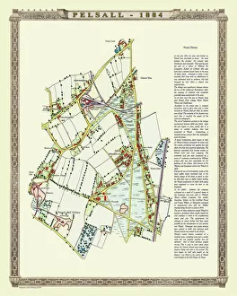
Old Map of the Village of Pelsall near Walsall 1884PL010
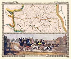
Old Map of the Turnpike Road u Erdington 1833 with Stagecoaches at "The Green"J130
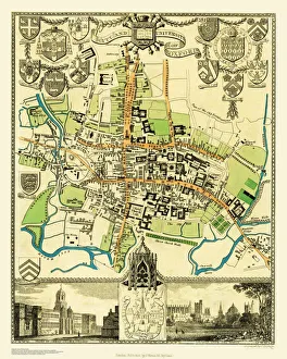
Old Map of the City Oxford 1836 by Thomas MouleThis is a fine decorative reproduction Map of The City of Oxford from the First Edition series of Thomas Moule Maps, originally Published in 1836
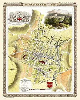
Old Map of Winchester 1805 by Cole and RoperAn attractive and detailed early 19th century reproduction town plan of Winchester 1805. First published by Cole and Roper as a finely engraved series of county maps
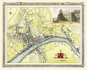
Old Map of Newcastle upon Tyne and Gateshead 1808 by Cole and RoperAn attractive and detailed early 19th century reproduction town plan of Newcastle upon Tyne and Gateshead 1808. First published by Cole and Roper as a finely engraved series of county maps
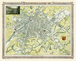
Old Map of Manchester 1807 by Cole and RoperAn attractive and detailed early 19th century reproduction town plan of Manchester 1807. First published by Cole and Roper as a finely engraved series of county maps
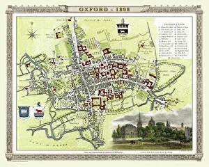
Old Map of Oxford 1808 by Cole and RoperAn attractive and detailed early 19th century reproduction plan of the City of Oxford 1808. First published by Cole and Roper as a finely engraved series of county maps
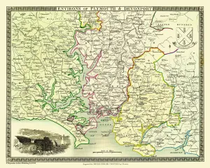
Old Map of the Environs of Plymouth and Devonport 1836 by Thomas MouleThis is a fine decorative reproduction Map of The Environs of Plymouth and Devonport from the First Edition series of Thomas Moule Maps, originally Published in 1836
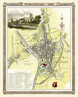
Old Map of Worcester 1808 by Cole and RoperAn attractive and detailed early 19th century reproduction town plan of Worcester 1808. First published by Cole and Roper as a finely engraved series of county maps
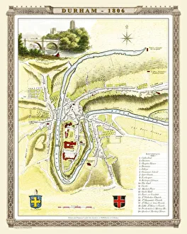
Old Map of Durham 1806 by Cole and RoperAn attractive and detailed early 19th century reproduction town plan of Durham 1805. First published by Cole and Roper as a finely engraved series of county maps
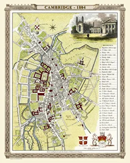
Old Map of Cambridge 1804 by Cole and RoperAn attractive and detailed early 19th century reproduction town plan of Cambridge 1804. First published by Cole and Roper as a finely engraved series of county maps
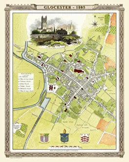
Old Map of Gloucester 1805 by Cole and RoperAn attractive and detailed early 19th century reproduction town plan of Gloucester 1805. First published by Cole and Roper as a finely engraved series of county maps
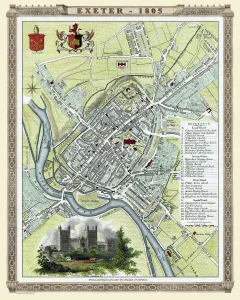
Old Map of Exeter 1805 by Cole and RoperAn attractive and detailed early 19th century reproduction town plan of Exeter 1805. First published by Cole and Roper as a finely engraved series of county maps
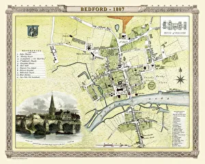
Old Map of Bedford 1807 by Cole and RoperAn attractive and detailed early 19th century reproduction town plan of Bedford, Bedfordshire. First published by Cole and Roper as a finely engraved series of county maps
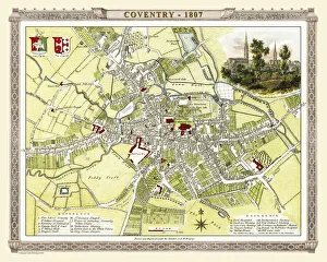
Old Map of Coventry 1807 by Cole and RoperAn attractive and detailed early 19th century reproduction town plan of Coventry 1805. First published by Cole and Roper as a finely engraved series of county maps
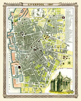
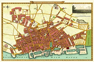
Old Map of Liverpool 1807 by Cole and RoperAn attractive and detailed early 19th century reproduction town plan of Liverpool 1807. First published by Cole and Roper as a finely engraved series of county maps
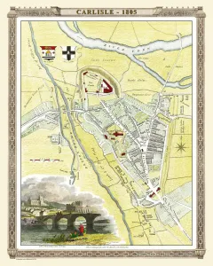
Old Map of Carlisle 1805 by Cole and RoperAn attractive and detailed early 19th century reproduction town plan of Carlisle 1805. First published by Cole and Roper as a finely engraved series of county maps
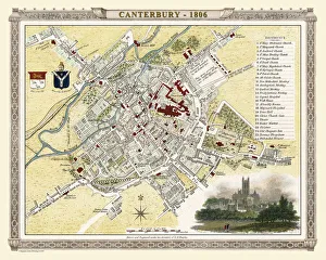
Old Map of Canterbury 1806 by Cole and RoperAn attractive and detailed early 19th century reproduction town plan of Canterbury 1806. First published by Cole and Roper as a finely engraved series of county maps
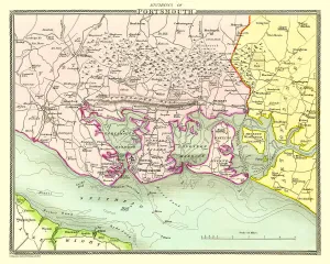
Old Map of the Environs of Portsmouth 1836 by Thomas MouleThis is a fine decorative reproduction Map of The Environs of Portsmouth from the First Edition series of Thomas Moule Maps, originally Published in 1836
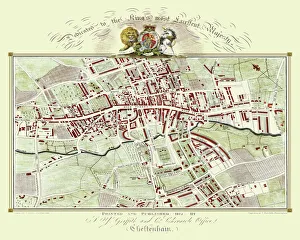
Old Map of Cheltenham 1825 by Griffith sFine reproduction in full colour of Griffiths new historical description of Cheltenham and its vicinity originally published in 1825
Old Map of the Environs of Bath and Bristol 1836 by Thomas MouleThis is a fine decorative reproduction Map of The Environs of Bath and Bristol from the First Edition series of Thomas Moule Maps, originally Published in 1836
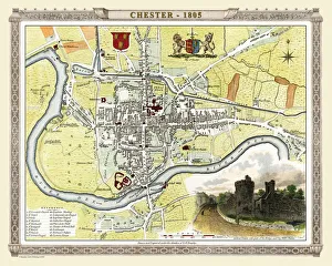
Old Map of Chester 1805 by Cole and RoperAn attractive and detailed early 19th century reproduction town plan of Chester 1805. First published by Cole and Roper as a finely engraved series of county maps
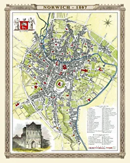
Old Map of Norwich 1807 by Cole and RoperAn attractive and detailed early 19th century reproduction plan of the City of Norwich 1807. First published by Cole and Roper as a finely engraved series of county maps
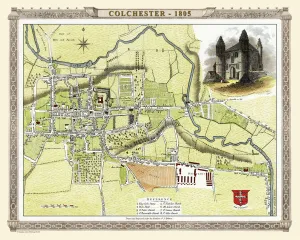
Old Map of Colchester 1805 by Cole and RoperAn attractive and detailed early 19th century reproduction town plan of Colchester 1805. First published by Cole and Roper as a finely engraved series of county maps
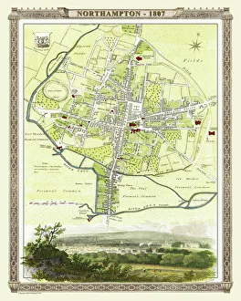
Old Map of Northampton 1807 by Cole and RoperAn attractive and detailed early 19th century reproduction town plan of Northampton 1807. First published by Cole and Roper as a finely engraved series of county maps
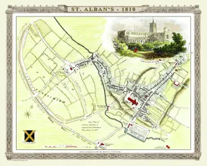
Old Map of St Albans 1810 by Cole and RoperAn attractive and detailed early 19th century reproduction town plan of St Albans 1810. First published by Cole and Roper as a finely engraved series of county maps
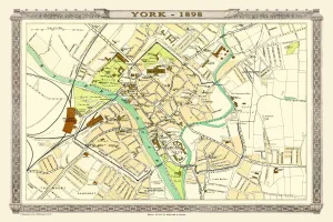
Old Map of York 1898 from the Royal Atlas by BartholomewA fine very detailed plan of the City of York remastered from an original contained within " The Royal Atlas of England and Wales" ; edited by J.G
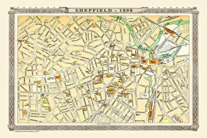
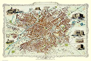
Old Map of Sheffield 1898 from the Royal Atlas by BartholomewA fine very detailed plan of the City of Sheffield remastered from an original contained within " The Royal Atlas of England and Wales" ; edited by J.G
Old Map of Map of Liverpool Surveyed in 1795 by John StockdaleJ016
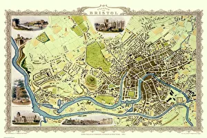
Old Map of Bristol 1851 by John TallisThis 1851 John Tallis map of Bristol shows the new course of the River Avon and the Floating Harbour. At Clifton Down the famous suspension bridge is yet to be constructed
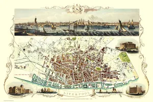
Old Map of Liverpool 1851 by John TallisRunning along the entire length of the plan of Liverpool in Lancashire by John Tallis 1851 is a most attractive view across the River Mersey from Birkenhead to the Victorian Liverpool skyline
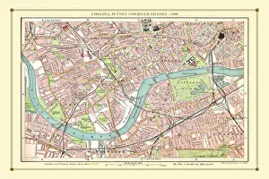
Old Street Map of Chelsea, Putney and River Thames 1908Detailed colour Street Plan of London from 1908 covering the area around Chelsea, Putney and the River Thames. The image has been remastered from Bartholomews Handy Atlas of London and Suburbs 1908
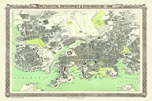
Old Map of Plymouth, Devonport and Stonehouse 1898 from the Royal Atlas by BartholomewA fine very detailed plan of the Port City of Plymouth with Devonport and Stonehouse, remastered from an original contained within " The Royal Atlas of England and Wales" ; edited by J.G
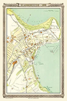
Old Map of Scarborough 1898 from the Royal Atlas by BartholomewA fine very detailed plan of the Seaside Town of Scarborough from 1898 remastered from an original contained within " The Royal Atlas of England and Wales" ; edited by J.G
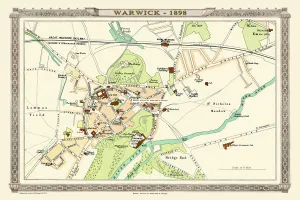
Old Map of Warwick 1898 from the Royal Atlas by BartholomewA fine very detailed plan of the City of Warwick remastered from an original contained within " The Royal Atlas of England and Wales" ; edited by J.G
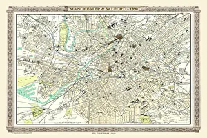
Old Map of Manchester and Salford 1898 from the Royal Atlas by BartholomewA fine very detailed plan of the City of Manchester and Salford remastered from an original contained within " The Royal Atlas of England and Wales" ; edited by J.G
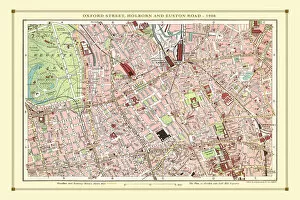
Old Street Map of Oxford Street, Holborn and Euston Road 1908Detailed colour Street Plan of London from 1908 covering the area around Oxford Street, Holborn and Euston Road.The image has been remastered from Bartholomews Handy Atlas of London and Suburbs 1908
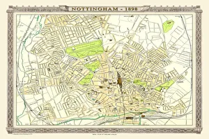
Old Map of Nottingham 1898 from the Royal Atlas by BartholomewA fine very detailed plan of the City of Nottingham remastered from an original contained within " The Royal Atlas of England and Wales" ; edited by J.G
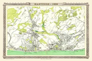
Old Map of Hastings 1898 from the Royal Atlas by BartholomewA fine very detailed town plan of Hastings from 1898 remastered from an original contained within " The Royal Atlas of England and Wales" ; edited by J.G
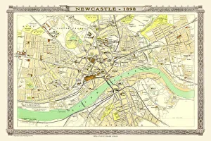
Old Map of Newcastle 1898 from the Royal Atlas by BartholomewA fine very detailed plan of the City of Newcastle remastered from an original contained within " The Royal Atlas of England and Wales" ; edited by J.G
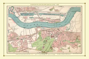
Old Street Map of Woolwich and Thames Docklands 1908Detailed colour Street Plan of London from 1908 covering the area around Woolwich and the Thames Docklands.The image has been remastered from Bartholomews Handy Atlas of London and Suburbs 1908
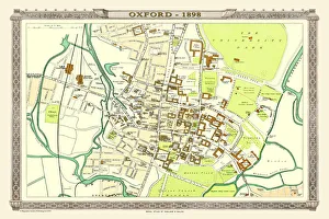
Old Map of Oxford 1898 from the Royal Atlas by BartholomewA fine very detailed plan of the City of Oxford remastered from an original contained within " The Royal Atlas of England and Wales" ; edited by J.G
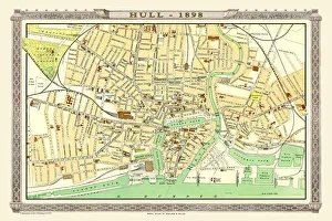
Old Map of Hull 1898 from the Royal Atlas by BartholomewA fine very detailed plan of the City of Hull remastered from an original contained within " The Royal Atlas of England and Wales" ; edited by J.G
Old Map of Manchester 1851 by John TallisThis John Tallis Victorian map, 1851, of Manchester in Lancashire covers the districts of Salford, Manchester, Ardwick, Chorlton and Hulme
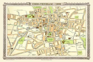
Old Map of Central Cheltenham 1898 from the Royal Atlas by BartholomewA fine very detailed town plan of Cheltenham from 1898 remastered from an original contained within " The Royal Atlas of England and Wales" ; edited by J.G
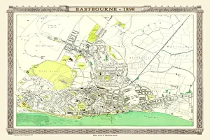
Old Map of Eastbourne 1898 from the Royal Atlas by BartholomewA fine very detailed plan of the Seaside Town of Eastbourne from 1898 remastered from an original contained within " The Royal Atlas of England and Wales" ; edited by J.G
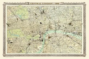
Old Map of Central London 1898 from the Royal Atlas by BartholomewA fine very detailed plan of Central London from 1898 remastered from an original contained within " The Royal Atlas of England and Wales" ; edited by J.G
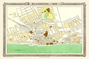
Old Map of Blackpool 1898 from the Royal Atlas by BartholomewA fine very detailed plan of the Town of Blackpool remastered from an original contained within " The Royal Atlas of England and Wales" ; edited by J.G