Home > British Town And City Plans > English & Welsh PORTFOLIO
Tote Bag : A Conjectural Picture Map of Birmingham In 1730


![]()
Home Decor from MapSeeker
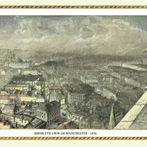
A Conjectural Picture Map of Birmingham In 1730
This is a striking colourful picture map of Birmingham in 1730, originally imagined & drawn from city records by Bernard Sleigh and lettered by I.A. Ellis, 1923. Originally printed by the Kynoch Press A.D. 1924, and published by Cornish Bros. Limited 39 New Street. This is a wonderfully detailed colourful pictorial map showing roads, the river Rea, principal buildings and the many dwellings, artisans workshops at a time when Birmingham rural aspect was about to transform into an industrial town rapidly growing outwards consuming the then far off villages that now form part of what is now the countries second city
Media ID 20347731
Canvas Tote Bag
Our tote bags are made from soft, durable, poly-poplin fabric and include a one inch (2.5cm) black strap for easy carrying on your shoulder. All seams are double-stitched for added durability. Each tote bag is machine-washable in cold water and is printed on both sides using the same image. Approximate size of bag is 50x33cm (20"x13")
Our tote bags are made from soft durable fabric and include a strap for easy carrying
Estimated Product Size is 50cm x 32.7cm (19.7" x 12.9")
These are individually made so all sizes are approximate
FEATURES IN THESE COLLECTIONS
> British Town And City Plans
> English & Welsh PORTFOLIO
> Pictorial Maps and Pictorial History
MADE IN THE UK
Safe Shipping with 30 Day Money Back Guarantee
FREE PERSONALISATION*
We are proud to offer a range of customisation features including Personalised Captions, Color Filters and Picture Zoom Tools
SECURE PAYMENTS
We happily accept a wide range of payment options so you can pay for the things you need in the way that is most convenient for you
* Options may vary by product and licensing agreement. Zoomed Pictures can be adjusted in the Cart.