Home > British Town And City Plans > English & Welsh PORTFOLIO
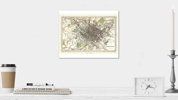
Photographic Print : Old Map of Birmingham 1866 by Fullarton & Co

![]()
Photo Prints from MapSeeker
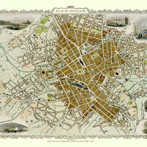
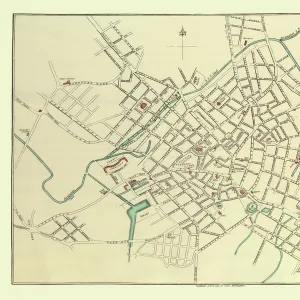
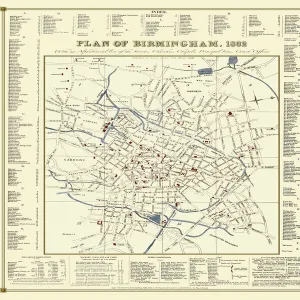
Old Map of Birmingham 1866 by Fullarton & Co
This detailed reproduction plan of Birmingham has been re-worked from an antique originally published in the 1860,s by Archibold Fullarton & Company. He was a well known publisher of books in the 19th century; however it is of significant note that the engraver, John Bartholomew Junior, had followed in the footsteps of his father and grandfather, establishing the reputation of the famous Bartholomew map-making company. John Bartholomew Junior was the first person to use layer colouring to indicate land heights and sea depths. The Bartholomew map-making generations would continue to prosper, introducing new map-making techniques into the 20th century. The plan of 1866 covers a greater area than previous plans of Birmingham, stretching out to include Aston, an area as yet not incorporated into Birmingham. To the south there is Edgbaston, the small village of Harborne is just about featured. However, this plan reveals something new, something that Birminghams people had needed for quite some time, public open space. The green coloured areas add a splash of colour to the plan, highlighting the arrival of BirminghamAEs first parks
Media ID 20347164
© Mapseeker Digital Ltd
Birmingham Birmingham City Birmingham City Map Birmingham Map Birmingham Town Plan City Of Birmingham Map Historic Birmingham Map Historic Map Map Of Birmingham Old Map Of Birmingham Old Town Plan Town Plan Of Birmingham
10"x8" (25x20cm) Photo Print
Printed on archival quality paper for unrivalled stable artwork permanence and brilliant colour reproduction with accurate colour rendition and smooth tones. Printed on professional 234gsm Fujifilm Crystal Archive DP II paper. 10x8 for landscape images, 8x10 for portrait images.
Our Photo Prints are in a large range of sizes and are printed on Archival Quality Paper for excellent colour reproduction and longevity. They are ideal for framing (our Framed Prints use these) at a reasonable cost. Alternatives include cheaper Poster Prints and higher quality Fine Art Paper, the choice of which is largely dependant on your budget.
Estimated Image Size (if not cropped) is 25.4cm x 16.9cm (10" x 6.7")
Estimated Product Size is 25.4cm x 20.3cm (10" x 8")
These are individually made so all sizes are approximate
Artwork printed orientated as per the preview above, with landscape (horizontal) orientation to match the source image.
MADE IN THE UK
Safe Shipping with 30 Day Money Back Guarantee
FREE PERSONALISATION*
We are proud to offer a range of customisation features including Personalised Captions, Color Filters and Picture Zoom Tools
SECURE PAYMENTS
We happily accept a wide range of payment options so you can pay for the things you need in the way that is most convenient for you
* Options may vary by product and licensing agreement. Zoomed Pictures can be adjusted in the Cart.