Home > British Town And City Plans > English & Welsh PORTFOLIO
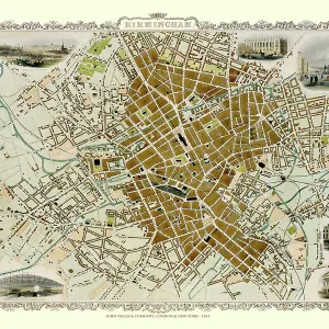
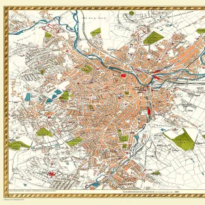
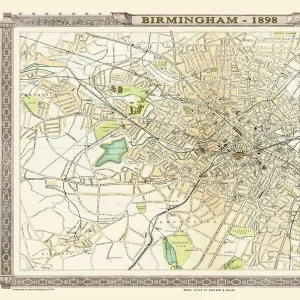
Old Map of Birmingham 1893 from the Comprehensive Gazetteer Atlas of England and Wales

![]()
Wall Art and Photo Gifts from MapSeeker
Old Map of Birmingham 1893 from the Comprehensive Gazetteer Atlas of England and Wales
This detailed reproduction plan of Birmingham has been re-worked from an antique originally published in the oComprehensive Gazetteer of England and Waleso 1893. All roads, railways and individual stations have been identified. The parks in and around Birmingham are now established, this map is most likely to be the first to show the Warwickshire Cricket Ground. The village of Harborne to the bottom left of the plan is yet to be drawn into the expanding conurbation. The plan includes Handsworth, Lozzells, Gibheath, Winston Green, Hockley, Brookfields, Saltley, Ladywood, Deritend, Bordsley, Highgate, Sparkbrook, Harborne, Edgebaston, and Balsall Heath
Media ID 20347432
Birmingham Birmingham City Birmingham City Map Birmingham Map Birmingham Town Plan City Of Birmingham Map Historic Birmingham Map Historic Map Map Of Birmingham Old Map Of Birmingham Old Town Plan Town Plan Of Birmingham
MADE IN THE UK
Safe Shipping with 30 Day Money Back Guarantee
FREE PERSONALISATION*
We are proud to offer a range of customisation features including Personalised Captions, Color Filters and Picture Zoom Tools
SECURE PAYMENTS
We happily accept a wide range of payment options so you can pay for the things you need in the way that is most convenient for you
* Options may vary by product and licensing agreement. Zoomed Pictures can be adjusted in the Basket.