Home > British Town And City Plans > English & Welsh PORTFOLIO
Photo Mug : Old Map of Boston England 1836 by Thomas Moule


![]()
Home Decor from MapSeeker
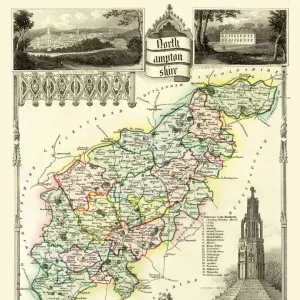
Old Map of Boston England 1836 by Thomas Moule
This is a fine decorative reproduction Map of The Town of Boston from the First Edition series of Thomas Moule Maps, originally Published in 1836
Media ID 20348268
Historic Map Moule Map Old Town Plan Thomas Moule Thomas Moule Map Town Plan
Photo Mug
A personalised photo mug blends sentimentality with functionality, making an ideal gift for cherished loved ones, close friends, or valued colleagues. Preview may show both sides of the same mug.
Elevate your coffee or tea experience with our premium white ceramic mug. Its wide, comfortable handle makes drinking easy, and you can rely on it to be both microwave and dishwasher safe. Sold in single units, preview may show both sides of the same mug so you can see how the picture wraps around.
Mug Size is 9.5cm high x 8cm diameter (3.7" x 3.1")
These are individually made so all sizes are approximate
MADE IN THE UK
Safe Shipping with 30 Day Money Back Guarantee
FREE PERSONALISATION*
We are proud to offer a range of customisation features including Personalised Captions, Color Filters and Picture Zoom Tools
SECURE PAYMENTS
We happily accept a wide range of payment options so you can pay for the things you need in the way that is most convenient for you
* Options may vary by product and licensing agreement. Zoomed Pictures can be adjusted in the Cart.