Home > British Town And City Plans > English & Welsh PORTFOLIO
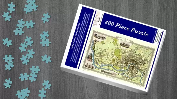
Jigsaw Puzzle : Old Map of Bristol 1851 by John Tallis


![]()
Jigsaw Puzzles from MapSeeker
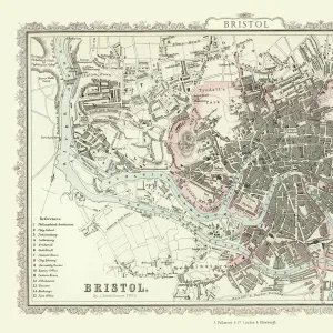
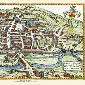
Old Map of Bristol 1851 by John Tallis
This 1851 John Tallis map of Bristol shows the new course of the River Avon and the Floating Harbour. At Clifton Down the famous suspension bridge is yet to be constructed, but clearly marked as Proposed Suspension Bridge, it was officially opened over a decade later in 1864. The illustrations are of Clifton Down from Rownham Ferry, south side of Bristol Cathedral, Clifton Observatory, High Cross Green, Redcliff Church and a busy scene across Broad Quay Bristol
Media ID 20347959
Historic Map John Tallis John Tallis Map Old Town Plan Tallis Map
Jigsaw Puzzle (400 Pieces)
400 piece puzzles are custom made in the UK and hand-finished on 100% recycled 1.5 mm millboard. There is a level of repetition in jigsaw shapes with each matching piece away from its pair. The completed puzzle measures 31x47cm and is delivered packaged in an attractive presentation box specially designed to fit most letter box slots
Jigsaw Puzzles are an ideal gift for any occasion
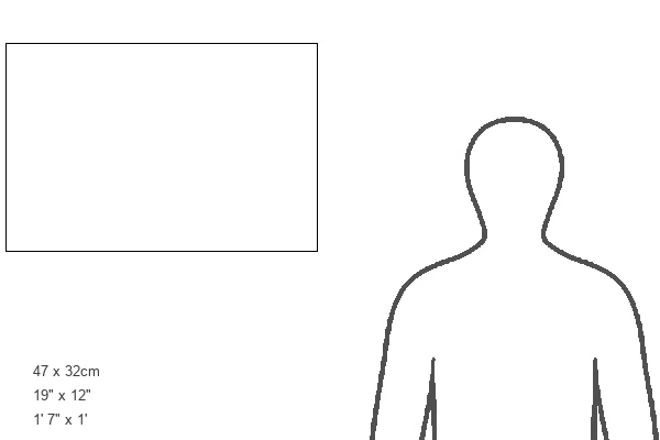
Estimated Product Size is 47.2cm x 31.5cm (18.6" x 12.4")
These are individually made so all sizes are approximate
Artwork printed orientated as per the preview above, with landscape (horizontal) or portrait (vertical) orientation to match the source image.
MADE IN THE UK
Safe Shipping with 30 Day Money Back Guarantee
FREE PERSONALISATION*
We are proud to offer a range of customisation features including Personalised Captions, Color Filters and Picture Zoom Tools
SECURE PAYMENTS
We happily accept a wide range of payment options so you can pay for the things you need in the way that is most convenient for you
* Options may vary by product and licensing agreement. Zoomed Pictures can be adjusted in the Cart.