Home > British Town And City Plans > English & Welsh PORTFOLIO
Tote Bag : Old map of Liverpool 1650 by Thomas Kaye


![]()
Home Decor from MapSeeker
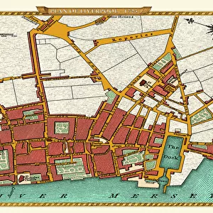
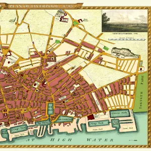
Old map of Liverpool 1650 by Thomas Kaye
An interesting map originally published in 1829 by Thomas Kaye, this reproduction map represents the town of Liverpool in 1650. Thomas made a copy from the original drawing of 1650 that was deposited in the Court of the Duchy of Lancaster as well as using other authentic and original documents. This fascinating plan shows Liverpool many years before it transformed into one of the largest and famous sea ports in the World. LiverpoolAEs long gone Castle is prominent along with other famous landmarks
Media ID 20346931
City Of Liverpool Map Historic Liverpool Map Historic Map Liverpool Liverpool City Liverpool City Map Liverpool Map Liverpool Town Plan Map Of Liverpool Old Map Of Liverpool Old Town Plan Town Plan Of Liverpool
Canvas Tote Bag
Our tote bags are made from soft, durable, poly-poplin fabric and include a one inch (2.5cm) black strap for easy carrying on your shoulder. All seams are double-stitched for added durability. Each tote bag is machine-washable in cold water and is printed on both sides using the same image. Approximate size of bag is 50x33cm (20"x13")
Our tote bags are made from soft durable fabric and include a strap for easy carrying
Estimated Product Size is 50cm x 32.7cm (19.7" x 12.9")
These are individually made so all sizes are approximate
MADE IN THE UK
Safe Shipping with 30 Day Money Back Guarantee
FREE PERSONALISATION*
We are proud to offer a range of customisation features including Personalised Captions, Color Filters and Picture Zoom Tools
SECURE PAYMENTS
We happily accept a wide range of payment options so you can pay for the things you need in the way that is most convenient for you
* Options may vary by product and licensing agreement. Zoomed Pictures can be adjusted in the Cart.