
Home > British Town And City Plans > English & Welsh PORTFOLIO

Old Map of Plymouth Devonport and Stonehouse 1851 by John Tallis

 : Old Map of Plymouth Devonport and Stonehouse 1851 by John Tallis


Choose Your Product


We accept all major payment options so you can pay for the things you need in the way that is most convenient for you

MapSeeker Photo Prints and Wall Art

Old Map of Plymouth Devonport and Stonehouse 1851 by John Tallis

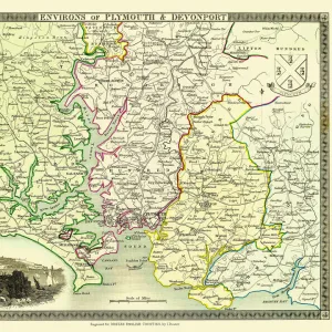
An attractive Victorian plan of Plymouth in Devon by John Tallis 1851, with Morice Town, Higher Stoke, Stoke, Devonport and Stonehouse. There are three illustrations on the plan of Plymouth, the Column, a view across Plymouth Sound and a busy scene across to Plymouth and the famous Citadel

Media ID 20347632

Historic Map John Tallis John Tallis Map Old Town Plan Tallis Map

Your artwork will be printed orientated as per the preview above, with landscape (horizontal) or portrait (vertical) orientation to match the source image


Made in USA
Safe Shipping, Easy Returns

FREE PERSONALISATION
We are proud to offer a range of customisation including Cropping, Captions, and Filters. Zoom Cropping can be adjusted in the basket

SECURE PAYMENTS
We accept all major payment options so you can pay for the things you need in the way that is most convenient for you


redeem
Beautiful Photo Prints and Gifts
image
Professionally printed
inventory
Photo Prints are in stock
thumb_up
Professional Quality Finish
diamond
Made With High Grade Materials
inventory_2
Carefully Packed To Aid Safe Arrival


Similar Pictures


Old Map of Plymouth, Devonport and Stonehouse 1898 from the Royal Atlas by Bartholomew
Old Map of Bath 1851 by John Tallis
Old Map of the Environs of Plymouth and Devonport 1836 by Thomas Moule
Old Map of the Grand Junction Railway 1837
Old Map of the Royal Town of Sutton Coldfield 1765 by John Snape
Old Map of the World 1963
Old Map of Blackpool 1898 from the Royal Atlas by Bartholomew
Old Road Strip Map (PLATE 10) The Road from London to the City of Bristol
Old Map of Leeds 1866 by Fullarton & Co
Old Map of the Western Isles from the Philips Handy Atlas of 1882
Old Map of Brighton 1851 by John Tallis
Old County Map of Cornwall 1611 by John Speed

+

Shipping

+

Choices

+

Guarantee