Home > British Town And City Plans > English & Welsh PORTFOLIO
Old Street Map of The Isle of Dogs and River Thames at Greenwich 1908

![]()
Wall Art and Photo Gifts from MapSeeker
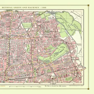
Old Street Map of The Isle of Dogs and River Thames at Greenwich 1908
Detailed colour Street Plan of London from 1908 covering the area around The Isle of Dogs and The River Thames at Greenwich.The image has been remastered from Bartholomews Handy Atlas of London and Suburbs 1908
Media ID 20347636
© Mapseeker Publishing Ltd, Collins Bartholomew Ltd
London Map London Street Plan Map Of Central London Map Of London Old London Street Map Old Map Of London Central Street Map Of London Street Plan
MADE IN THE UK
Safe Shipping with 30 Day Money Back Guarantee
FREE PERSONALISATION*
We are proud to offer a range of customisation features including Personalised Captions, Color Filters and Picture Zoom Tools
SECURE PAYMENTS
We happily accept a wide range of payment options so you can pay for the things you need in the way that is most convenient for you
* Options may vary by product and licensing agreement. Zoomed Pictures can be adjusted in the Basket.