Home > British Town And City Plans > English & Welsh PORTFOLIO
Glass Frame : Old Street Map of London South and River Thames 1908


![]()
Mounted Prints from MapSeeker
Old Street Map of London South and River Thames 1908
Detailed colour Street Plan of London from 1908. The street map features London South wiith the River Thames from Vauxhall Bridge to the London Docks and features Westminster, the Houses of Parliament. The area South of the Thames includes the London Boroughs of Lambeth, Walworth, Newington and Bermongsey
Media ID 20347791
© Mapseeker Publishing Ltd, Collins Bartholomew Ltd
London Street Plan Map Of Central London Old London Street Map Old Map Of London Central Street Plan
16"x12" Glass Mount
Wall mounted (no integral stand) our range of glass mount frames are designed with a contemporary style and safety toughened glass. This black edged glass frame features a smooth chamfered edge and a stylish black border (on back face of the glass). Manufactured from 4mm thick glass, your 16x12 print is slotted into the back of the frame so can easily be changed if needed.
Tempered Glass Mounts are ideal for wall display, plus the smaller sizes can also be used free-standing via an integral stand
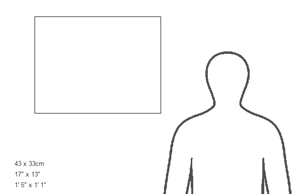
Estimated Image Size (if not cropped) is 40.6cm x 33.1cm (16" x 13")
Estimated Product Size is 43.2cm x 33.1cm (17" x 13")
These are individually made so all sizes are approximate
Artwork printed orientated as per the preview above, with landscape (horizontal) orientation to match the source image.
MADE IN THE UK
Safe Shipping with 30 Day Money Back Guarantee
FREE PERSONALISATION*
We are proud to offer a range of customisation features including Personalised Captions, Color Filters and Picture Zoom Tools
SECURE PAYMENTS
We happily accept a wide range of payment options so you can pay for the things you need in the way that is most convenient for you
* Options may vary by product and licensing agreement. Zoomed Pictures can be adjusted in the Cart.