Home > British Town And City Plans > Scottish PORTFOLIO
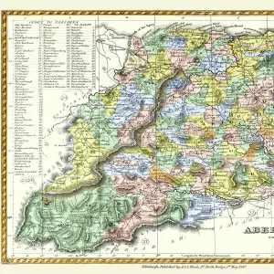
Old Map of Aberdeen 1851 by John Tallis

![]()
Wall Art and Photo Gifts from MapSeeker
Old Map of Aberdeen 1851 by John Tallis
Aberdeen in Scotland nestled on the River Dee with its famous Victorian Park and Harbour, John TallisAEs 1851 town plan perfectly captures this historic Scottish town during mid Victorian times. To the bottom right of the plan is a most attractive illustration of Aberdeen. At the top of the plan there is a view towards Castle Street. The other illustrations are of Old Don Bridge, North Church on King Street and a sailing ship on the German Ocean
Media ID 20347713
Historic Map John Tallis John Tallis Map Old Town Plan Tallis Map
MADE IN THE UK
Safe Shipping with 30 Day Money Back Guarantee
FREE PERSONALISATION*
We are proud to offer a range of customisation features including Personalised Captions, Color Filters and Picture Zoom Tools
SECURE PAYMENTS
We happily accept a wide range of payment options so you can pay for the things you need in the way that is most convenient for you
* Options may vary by product and licensing agreement. Zoomed Pictures can be adjusted in the Cart.