mail_outline sales@mediastorehouse.com
Astronomy, Celestial and Star Charts Collection13 items
England and Counties PORTFOLIO Collection111 items
20th Century PORTFOLIO Collection2 items
16th to 19th Century PORTFOLIO Collection4 items
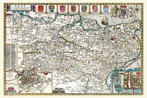
Old County Map of Kent 1611 by John SpeedA facimile of John Speeds historical map of Kent originally published for the " Theatre of the Empire of Great Britain", an atlas to accompany " a history of Great Britain"
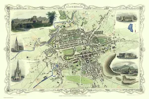
Old Map of Edinburgh Scotland 1851 by John TallisThis Victorian map of Edinburgh in Scotland by John Tallis is dominated with a view to the top right across Edinburgh from the north- west towards Edinburgh Castle
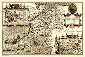
Old County Map of Caernarvonshire, Wales 1611 by John SpeedA facimile of John Speeds historical map of Caernarvonshire originally published for the " Theatre of the Empire of Great Britain"
Old County Map of Buckinghamshire 1648 by Johan Blaeu from the Atlas NovusThis detailed and most attractive reproduction map of Buckinghamshire has been carefully art worked from a scan of an antique original
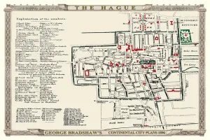
George Bradshaws Plan of The Hague, Netherlands1896This is a very detailed Plan of The Hague showing the streets, canals, principal buildings, railways and railway stations
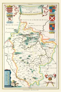
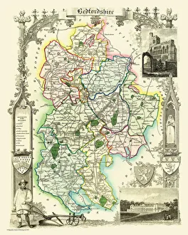
Old County Map of Bedfordshire 1648 by Johan Blaeu from the Atlas NovusThis detailed and most attractive reproduction map of Bedfordshire has been carefully art worked from a scan of an antique original
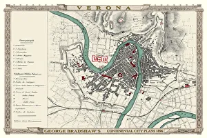
George Bradshaws Plan of Verona, Italy 1896This is a very detailed Plan of Verona, which features streets, canals, principal buildings, railways and railway stations
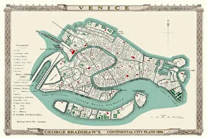
George Bradshaws Plan of Venice, Italy 1896This is a very detailed Plan of Venice, which features streets, canals, principal buildings, railways and railway stations
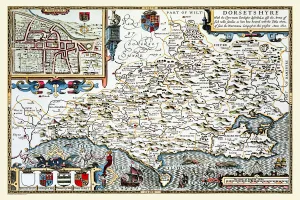
Old County Map of Dorsetshire 1611 by John SpeedA facimile of John Speeds historical map of Dorsetshire originally published for the " Theatre of the Empire of Great Britain", an atlas to accompany " a history of Great Britain"
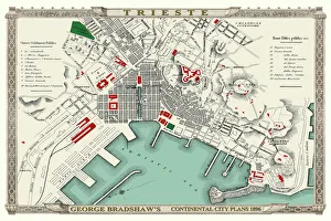
George Bradshaws Plan of Trieste, Italy 1896This is a very detailed Plan of the Port and City of Trieste showing the Port, streets, canals, principal buildings, railways and railway stations
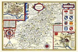
Old County Map of Northamptonshire 1611 by John SpeedA facimile of John Speeds historical map of Northamptonshire originally published for the " Theatre of the Empire of Great Britain"
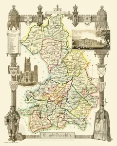
Old County Map of Cambridgeshire 1648 by Johan Blaeu from the Atlas NovusThis detailed and most attractive reproduction map of Cambridgeshire has been carefully art worked from a scan of an antique original
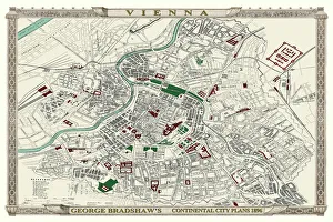
George Bradshaws Plan of Vienna, Austria 1896This is a very detailed Plan of Vienna, which features streets, canals, principal buildings, railways and railway stations
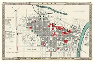
George Bradshaws Plan of Turin, Italy1896This is a very detailed Plan of Turin, which features streets, canals, principal buildings, railways and railway stations
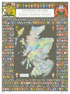
The Historic Map of Scotland "Scotland of Old"Now republished at its original full size, the Scotland of Old Map, also known as the Bartholomew Clan Map of Scotland, features " The Lands", " The Arms"
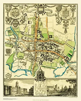
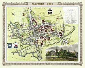
Old Map of the City Oxford 1836 by Thomas MouleThis is a fine decorative reproduction Map of The City of Oxford from the First Edition series of Thomas Moule Maps, originally Published in 1836
Old County Map of Cambridgeshire 1836 by Thomas MouleThis is a fine decorative reproduction County Map of Cambridgeshire from the First Edition series of Thomas Moule Maps, originally Published in 1836
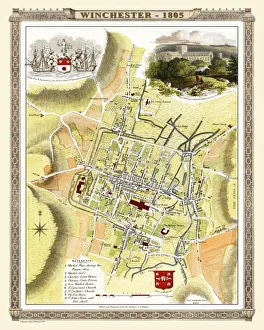
Old Map of Winchester 1805 by Cole and RoperAn attractive and detailed early 19th century reproduction town plan of Winchester 1805. First published by Cole and Roper as a finely engraved series of county maps
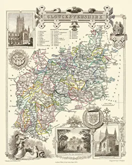
Old County Map of Gloucestershire 1836 by Thomas MouleThis is a fine decorative reproduction County Map of Gloucestershire from the First Edition series of Thomas Moule Maps, originally Published in 1836
Old County Map of Bedfordshire 1836 by Thomas MouleThis is a fine decorative reproduction County Map of Bedfordshire from the First Edition series of Thomas Moule Maps, originally Published in 1836
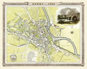
Old Map of Derby 1806 by Cole and RoperAn attractive and detailed early 19th century reproduction town plan of Derby 1805. First published by Cole and Roper as a finely engraved series of county maps
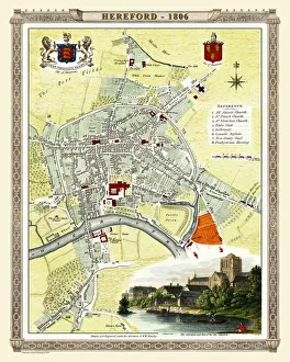
Old Map of Hereford 1806 by Cole and RoperAn attractive and detailed early 19th century reproduction town plan of Hereford 1806. First published by Cole and Roper as a finely engraved series of county maps
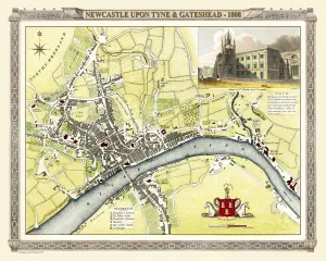
Old Map of Newcastle upon Tyne and Gateshead 1808 by Cole and RoperAn attractive and detailed early 19th century reproduction town plan of Newcastle upon Tyne and Gateshead 1808. First published by Cole and Roper as a finely engraved series of county maps
Old County Map of Berkshire 1836 by Thomas MouleThis is a fine decorative reproduction County Map of Berkshire from the First Edition series of Thomas Moule Maps, originally Published in 1836
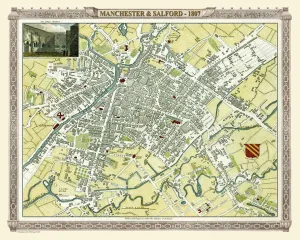
Old Map of Manchester 1807 by Cole and RoperAn attractive and detailed early 19th century reproduction town plan of Manchester 1807. First published by Cole and Roper as a finely engraved series of county maps
Old County Map of Herefordshire 1836 by Thomas MouleThis is a fine decorative reproduction County Map of Herefordshire from the First Edition series of Thomas Moule Maps, originally Published in 1836
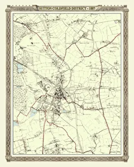
Old Map of the District of Sutton Coldfield in the West Midlands 1887PL016
Old County Map of Suffolk 1836 by Thomas MouleThis is a fine decorative reproduction County Map of Suffolk from the First Edition series of Thomas Moule Maps, originally Published in 1836
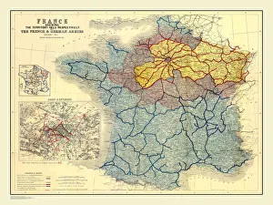
Map of France Showing the Territories held respectively by the French and German Armies January 1871BAT01001
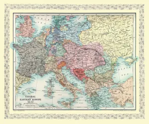
Map of Central Europe and Eastern Europe as it appeared between AD 1863 and AD 1897EHIST013
Old Map of Oxford 1808 by Cole and RoperAn attractive and detailed early 19th century reproduction plan of the City of Oxford 1808. First published by Cole and Roper as a finely engraved series of county maps
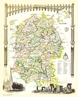
Old County Map of Wiltshire 1836 by Thomas MouleThis is a fine decorative reproduction County Map of Wiltshire from the First Edition series of Thomas Moule Maps, originally Published in 1836
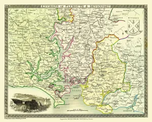
Old Map of the Environs of Plymouth and Devonport 1836 by Thomas MouleThis is a fine decorative reproduction Map of The Environs of Plymouth and Devonport from the First Edition series of Thomas Moule Maps, originally Published in 1836
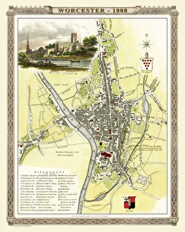
Old Map of Worcester 1808 by Cole and RoperAn attractive and detailed early 19th century reproduction town plan of Worcester 1808. First published by Cole and Roper as a finely engraved series of county maps
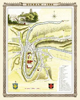
Old Map of Durham 1806 by Cole and RoperAn attractive and detailed early 19th century reproduction town plan of Durham 1805. First published by Cole and Roper as a finely engraved series of county maps
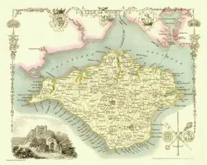
Old Map of The Isle of Wight 1836 by Thomas MouleThis is a fine decorative reproduction Map of The Isle of Wight from the First Edition series of Thomas Moule Maps, originally Published in 1836
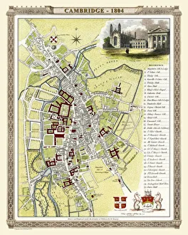
Old Map of Cambridge 1804 by Cole and RoperAn attractive and detailed early 19th century reproduction town plan of Cambridge 1804. First published by Cole and Roper as a finely engraved series of county maps
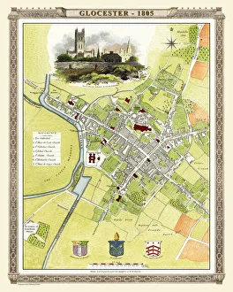
Old Map of Gloucester 1805 by Cole and RoperAn attractive and detailed early 19th century reproduction town plan of Gloucester 1805. First published by Cole and Roper as a finely engraved series of county maps
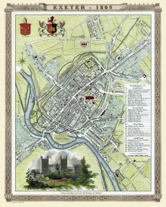
Old Map of Exeter 1805 by Cole and RoperAn attractive and detailed early 19th century reproduction town plan of Exeter 1805. First published by Cole and Roper as a finely engraved series of county maps
Old County Map of Westmoreland 1836 by Thomas MouleThis is a fine decorative reproduction County Map of Westmoreland from the First Edition series of Thomas Moule Maps, originally Published in 1836
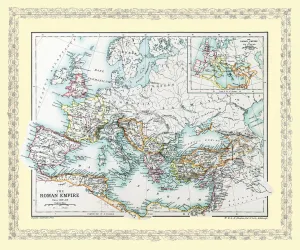
Map of Europe as it appeared in Roman Times circa AD 350EHISM001
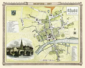
Old Map of Bedford 1807 by Cole and RoperAn attractive and detailed early 19th century reproduction town plan of Bedford, Bedfordshire. First published by Cole and Roper as a finely engraved series of county maps
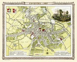
Old Map of Coventry 1807 by Cole and RoperAn attractive and detailed early 19th century reproduction town plan of Coventry 1805. First published by Cole and Roper as a finely engraved series of county maps
Old Map of the City of Cambridge 1836 by Thomas MouleThis is a fine decorative reproduction Map of The City of Cambridge from the First Edition series of Thomas Moule Maps, originally Published in 1836