mail_outline sales@mediastorehouse.com
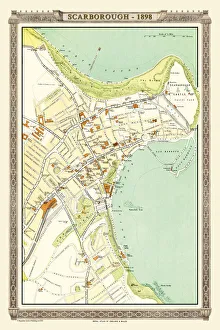
Old Map of Scarborough 1898 from the Royal Atlas by BartholomewA fine very detailed plan of the Seaside Town of Scarborough from 1898 remastered from an original contained within " The Royal Atlas of England and Wales" ; edited by J.G
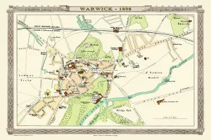
Old Map of Warwick 1898 from the Royal Atlas by BartholomewA fine very detailed plan of the City of Warwick remastered from an original contained within " The Royal Atlas of England and Wales" ; edited by J.G
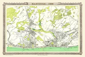
Old Map of Hastings 1898 from the Royal Atlas by BartholomewA fine very detailed town plan of Hastings from 1898 remastered from an original contained within " The Royal Atlas of England and Wales" ; edited by J.G
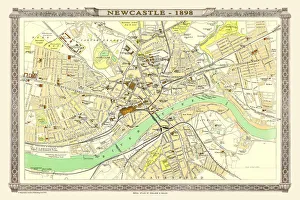
Old Map of Newcastle 1898 from the Royal Atlas by BartholomewA fine very detailed plan of the City of Newcastle remastered from an original contained within " The Royal Atlas of England and Wales" ; edited by J.G
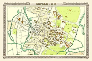
Old Map of Oxford 1898 from the Royal Atlas by BartholomewA fine very detailed plan of the City of Oxford remastered from an original contained within " The Royal Atlas of England and Wales" ; edited by J.G
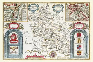
Old County Map of Buckinghamshire 1611 by John SpeedA fine reproduction of John Speeds historical map of Buckinghamshire originally published for the " Theatre of the Empire of Great Britain"
Old County Map of Sussex 1611 by John SpeedA facimile of John Speeds historical map of Sussex originally published for the " Theatre of the Empire of Great Britain", an atlas to accompany " a history of Great Britain"
Old County Map of Durham 1611 by John SpeedA facimile of John Speeds historical map of Durham originally published for the " Theatre of the Empire of Great Britain", an atlas to accompany " a history of Great Britain"
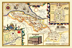
Old County Map of Flintshire 1611 by John SpeedA facimile of John Speeds historical map of Flintshire originally published for the " Theatre of the Empire of Great Britain", an atlas to accompany " a history of Great Britain"
Old Map of The Province of Leinster, Ireland 1611 by John SpeedA facimile of John Speeds historical map of the Province of Leinster originally published for the " Theatre of the Empire of Great Britain"
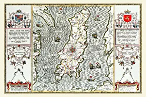
Old Map of The Isle of Man 1611 by John SpeedA facimile of John Speeds historical map of the Isle of Man originally published for the " Theatre of the Empire of Great Britain"
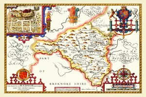
Old County Map of Radnorshire, Wales 1611 by John SpeedA facimile of John Speeds historical map of Radnorshire originally published for the " Theatre of the Empire of Great Britain", an atlas to accompany " a history of Great Britain"
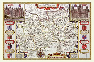
Old County Map of Essex 1611 by John SpeedA facimile of John Speeds historical map of Essex originally published for the " Theatre of the Empire of Great Britain", an atlas to accompany " a history of Great Britain"
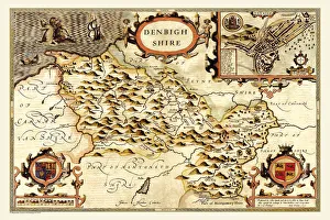
Old County Map of Denbighshire 1611 by John SpeedA facimile of John Speeds historical map of Denbighshire originally published for the " Theatre of the Empire of Great Britain", an atlas to accompany " a history of Great Britain"
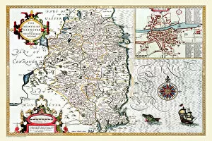
Old County Map of Cumberland 1611 by John SpeedA facimile of John Speeds historical map of Cumberland originally published for the " Theatre of the Empire of Great Britain", an atlas to accompany " a history of Great Britain"
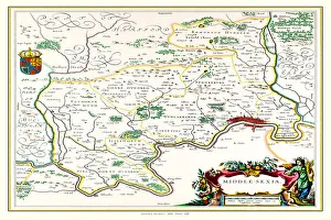
Old County Map of Middlesex 1648 by Johan Blaue from the Atlas NovusThis detailed and most attractive reproduction map of Middlesex has been carefully art worked from a scan of an antique original
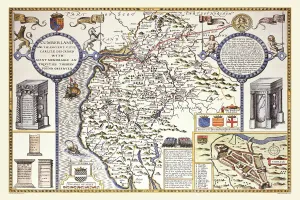
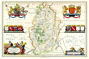
Old County Map of Nottinghamshire 1648 by Johan Blaeu from the Atlas NovusThis detailed and most attractive reproduction map of Nottinghamshire has been carefully art worked from a scan of an antique original
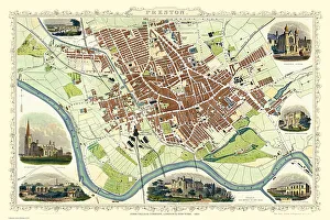
Old Map of Preston 1851 by John TallisThe River Ribble in Lancashire by John Tallis 1851 with a most rural presentation of Preston surrounded by numerous meadows and open fields. The plan is beautifully finished with seven illustrations
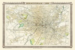
Old Map of Birmingham 1898 from the Royal Atlas by BartholomewA fine very detailed plan of the City of Birmingham remastered from an original contained within " The Royal Atlas of England and Wales" ; edited by J.G
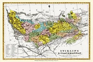
Old County Map of Stirling and Clackmannan Scotland 1847 by A&C BlackA finely detailed facimile remastered in full colour from an antique original map of Stirling and Clackmannan featured in A&C Blacks Atlas of 1847
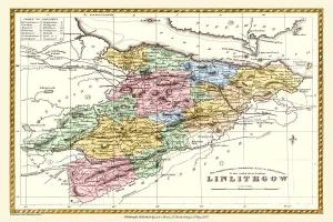
Old County Map of Linlithgow Scotland 1847 by A&C BlackA finely detailed facimile remastered in full colour from an antique original map of Linlithgow featured in A&C Blacks Atlas of 1847
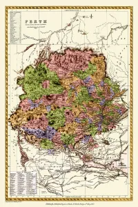
Old County Map of Perth Scotland 1847 by A&C BlackA finely detailed facimile remastered in full colour from an antique original map of Perthshire featured in A&C Blacks Atlas of 1847
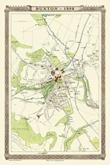
Old Map of Buxton 1898 from the Royal Atlas by BartholomewA fine very detailed plan of the Spa Town of Buxton from 1898 remastered from an original contained within " The Royal Atlas of England and Wales" ; edited by J.G
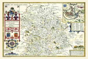
Old County Map of Shropshire 1611 by John SpeedA facimile of John Speeds historical map of Shropshire originally published for the " Theatre of the Empire of Great Britain", an atlas to accompany " a history of Great Britain"
Old County Map of Staffordshire 1611 by John SpeedA facimile of John Speeds historical map of Staffordshire originally published for the " Theatre of the Empire of Great Britain"
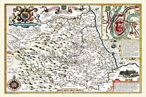
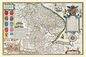
Old County Map of Lincolnshire 1611 by John SpeedA facimile of John Speeds historical map of Lincolnshire originally published for the " Theatre of the Empire of Great Britain", an atlas to accompany " a history of Great Britain"
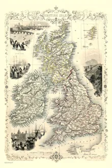
British Isles 1851A fine facimile artworked from an antique original map of The British Isles, issued as part of the 1851 edition of John Tallis and Companys " The Illustrated Atlas
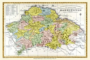
Old County Map of Haddington Scotland 1847 by A&C BlackA finely detailed facimile remastered in full colour from an antique original map of Haddington featured in A&C Blacks Atlas of 1847
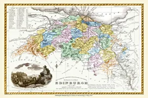
Old County Map of Edinburgh Scotland 1847 by A&C BlackA finely detailed facimile remastered in full colour from an antique original map of Edinburgh featured in A&C Blacks Atlas of 1847
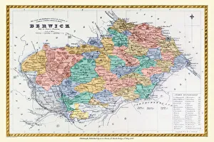
Old County Map of Berwick Scotland 1847 by A&C BlackA finely detailed facimile remastered in full colour from an antique original map of Berwick featured in A&C Blacks Atlas of 1847
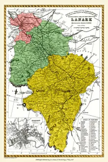
Old County Map of Lanark Scotland 1847 by A&C BlackA finely detailed facimile remastered in full colour from an antique original map of Lanarkshire featured in A&C Blacks Atlas of 1847
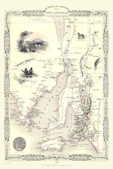
Part of South Australia 1851A fine facimile artworked from an antique original map of Part of South Australia, issued as part of the 1851 edition of John Tallis and Companys " The Illustrated Atlas
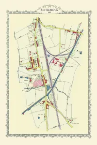
Old Map of Kettlebrook near Tamworth 1882PL057
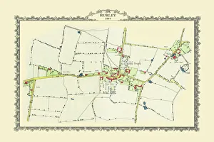
Old Map of the Village of Hurley in Warwickshire 1884PL056
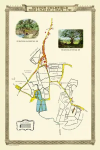
Old Map of the Royal Town of Sutton Coldfield 1765 by John SnapePL042
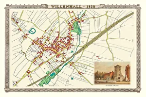
Old Map of the Town of Willenhall showing the Old Church of St Giles in 1838PL063
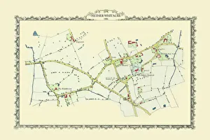
Old Map of the Village of Nether Whitacre in Warwickshire 1886PL058
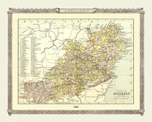
Old Map of the County of Aberdeen from the Philips Handy Atlas of 1882PHA002
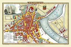
Old Map of Lancaster 1824 by Edward BainesThis is a fine detailed reproduction Map of The City of Lancaster, originally Published in 1836 by Edwward Baines
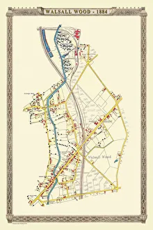
Old Map of the Village of Walsall Wood in Stafffordshire 1884PL38
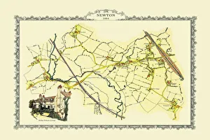
Old Map of Newton near West Bromwich showing Bishop Astburys Cottage 1884PL046
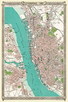
Old Map of Liverpool 1903J103
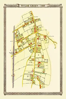
Old Map of Wylde Green near Erdington 1884PL044
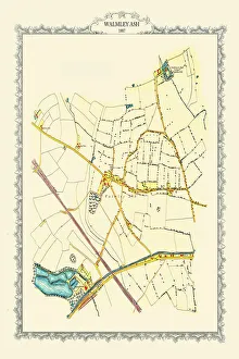
Old Map of Walmley Ash near Sutton Coldfield 1884PL049
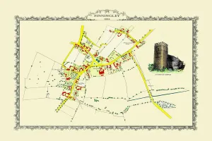
Old Map off the Village of Finningley in South Yorkshire 1884PL031
Old Map of Sheepy Magna to Sheepy Parva in Leicestershire 1885PL061
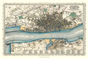
Old Map of Liverpool 1866 by Fullarton & CoThis is an interesting and detailed reproduction Victorian town plan of Liverpool which was originally published in John Marius Wilsons The Imperial Gazeteer of England and Wales (A. Fullarton & co)
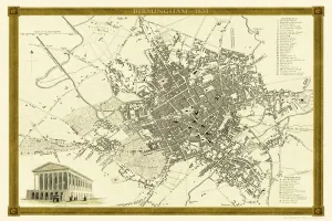
Old Map of Birmingham 1834 by John Dower and William OrrA highly detailed reproduction city map of Birmingham originally published in London, 1834. Interestingly it shows the planned route of the Grand Junction Railway coming into the North of Birmingham