mail_outline sales@mediastorehouse.com
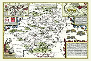
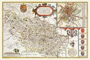
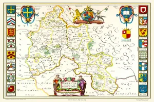
Old County Map of Hertfordshire 1611 by John SpeedA facimile of John Speeds historical map of Hertfordshire originally published for the " Theatre of the Empire of Great Britain"
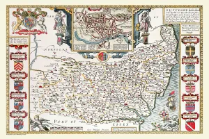
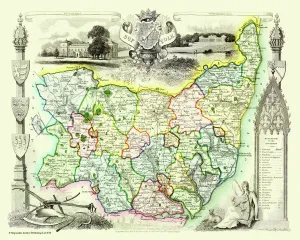
Old County Map of Suffolk 1611 by John SpeedA facimile of John Speeds historical map of Norfolk originally published for the " Theatre of the Empire of Great Britain", an atlas to accompany " a history of Great Britain"
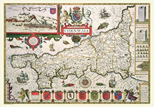
Old County Map of Cornwall 1611 by John SpeedA facimile of John Speeds historical map of Cornwall originally published for the " Theatre of the Empire of Great Britain", an atlas to accompany " a history of Great Britain"
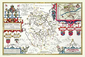
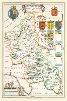
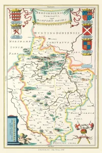
Old County Map of Bedfordshire 1611 by John SpeedA fine reproduction of John Speeds historical map of Bedfordshire originally published for the " Theatre of the Empire of Great Britain"
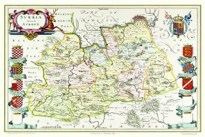
Old County Map of Surrey 1648 by Johan Blaeu from the Atlas NovusThis detailed and most attractive reproduction map of Surrey has been carefully art worked from a scan of an antique original
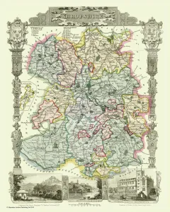
Old County Map of Shropshire 1836 by Thomas MouleThis is a fine decorative reproduction County Map of Shropshire from the First Edition series of Thomas Moule Maps, originally Published in 1836
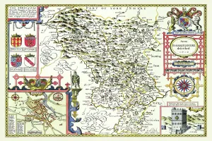
Old County Map of Derbyshire 1611 by John SpeedA facimile of John Speeds historical map of Derbyshire originally published for the " Theatre of the Empire of Great Britain", an atlas to accompany " a history of Great Britain"
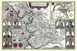
Old County Map of Lancashire 1611 by John SpeedA facimile of John Speeds historical map of Lancashire published for the " Theatre of the Empire of Great Britain", an atlas to accompany " a history of Great Britain"
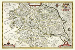
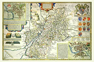
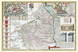
Old County Map of Yorkshire 1611 by John SpeedA facimile of John Speeds historical map of Yorkshire originally published for the " Theatre of the Empire of Great Britain", an atlas to accompany " a history of Great Britain"
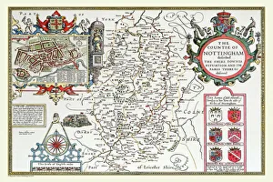
Old County Map of Nottinghamshire 1611 by John SpeedA facimile of John Speeds historical map of Nottinghamshire originally published for the " Theatre of the Empire of Great Britain"
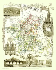
Old County Map of Worcestershire 1836 by Thomas MouleThis is a fine decorative reproduction County Map of Worcestershire from the First Edition series of Thomas Moule Maps, originally Published in 1836
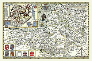
Old County Map of Somersetshire 1611 by John SpeedA facimile of John Speeds historical map of Somersetshire originally published for the " Theatre of the Empire of Great Britain"
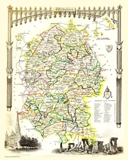
Old County Map of Wiltshire 1836 by Thomas MouleThis is a fine decorative reproduction County Map of Wiltshire from the First Edition series of Thomas Moule Maps, originally Published in 1836
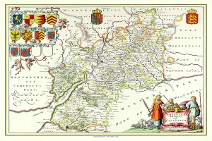
Old County Map of Warwickshire 1648 by Johan Blaeu from the Atlas NovusThis detailed and most attractive reproduction map of Warwickshire has been carefully art worked from a scan of an antique original
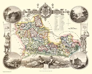
Old County Map of Suffolk 1836 by Thomas MouleThis is a fine decorative reproduction County Map of Suffolk from the First Edition series of Thomas Moule Maps, originally Published in 1836
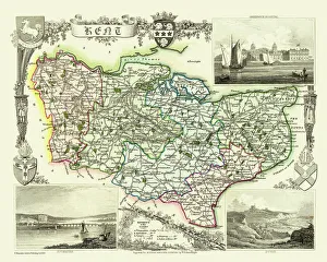
Old County Map of Kent 1836 by Thomas MouleThis is a fine decorative reproduction County Map of Kent from the First Edition series of Thomas Moule Maps, originally Published in 1836
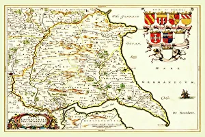
Old County Map of the East Riding of Yorkshire 1648 by Johan Blaeu from the Atlas NovusThis detailed and most attractive reproduction map of the East Riding of Yorkshire has been carefully art worked from a scan of an antique original
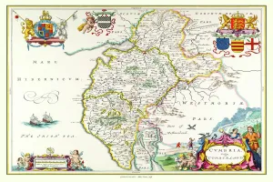
Old County Map of Cumbria 1648 by Johan Blaeu from the Atlas NovusThis detailed and most attractive reproduction map of Cumbria has been carefully art worked from a scan of an antique original
Old County Map of Gloucestershire 1648 by Johan Blaeu from the Atlas NovusThis detailed and most attractive reproduction map of Gloucestershire has been carefully art worked from a scan of an antique original
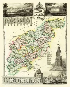
Old County Map of Northamptonshire 1836 by Thomas MouleThis is a fine decorative reproduction County Map of Northamptonshire from the First Edition series of Thomas Moule Maps, originally Published in 1836
Old County Map of Yorkshire West Riding 1611 by John SpeedA facimile of John Speeds historical map of Yorkshire West Riding originally published for the " Theatre of the Empire of Great Britain"
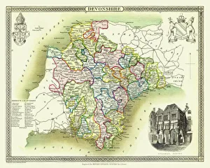
Old County Map of Devonshire 1836 by Thomas MouleThis is a fine decorative reproduction County Map of Devonshire from the First Edition series of Thomas Moule Maps, originally Published in 1836
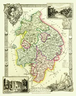
Old County Map of Warwickshire 1836 by Thomas MouleThis is a fine decorative reproduction County Map of Warwickshire from the First Edition series of Thomas Moule Maps, originally Published in 1836
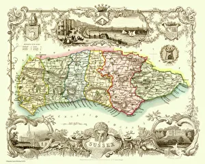
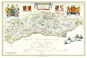
Old County Map of Sussex 1836 by Thomas MouleThis is a fine decorative reproduction County Map of Sussex from the First Edition series of Thomas Moule Maps, originally Published in 1836
Old County Map of Gloucestershire 1611 by John SpeedA facimile of John Speeds historical map of Gloucestershire originally published for the " Theatre of the Empire of Great Britain"
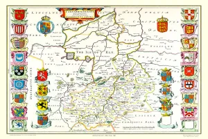
Old County Map of Cambridgeshire 1611 by John SpeedA facimile of John Speeds historical map of Cambridgeshire originally published for the " Theatre of the Empire of Great Britain"
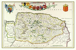
Old County Map of Norfolk 1648 by Johan Blaeu from the Atlas NovusThis detailed and most attractive reproduction map of Norfolk has been carefully art worked from a scan of an antique original
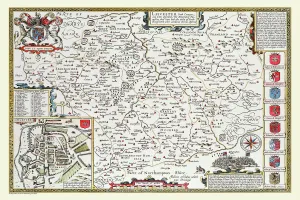
Old County Map of Leicestershire 1611 by John SpeedA facimile of John Speeds historical map of Leicestershire originally published for the " Theatre of the Empire of Great Britain"
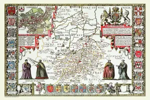
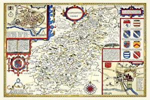
Old County Map of Northamptonshire 1611 by John SpeedA facimile of John Speeds historical map of Northamptonshire originally published for the " Theatre of the Empire of Great Britain"
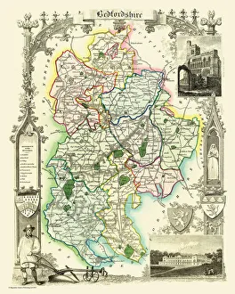
Old County Map of Bedfordshire 1836 by Thomas MouleThis is a fine decorative reproduction County Map of Bedfordshire from the First Edition series of Thomas Moule Maps, originally Published in 1836
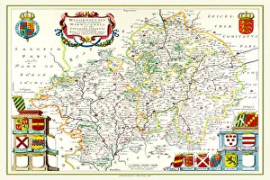
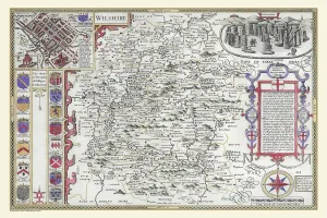
OldCounty Map of Wiltshire 1611 by John SpeedA facimile of John Speeds historical map of Wiltshire published for the " Theatre of the Empire of Great Britain", an atlas to accompany " a history of Great Britain"
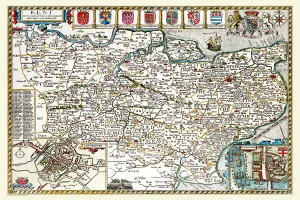
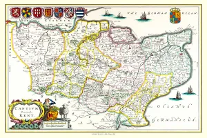
Old County Map of Kent 1611 by John SpeedA facimile of John Speeds historical map of Kent originally published for the " Theatre of the Empire of Great Britain", an atlas to accompany " a history of Great Britain"
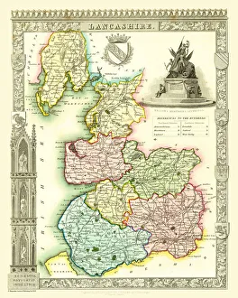
Old County Map of Lancashire 1836 by Thomas MouleThis is a fine decorative reproduction County Map of Lancashire from the First Edition series of Thomas Moule Maps, originally Published in 1836
Old County Map of Kent 1648 by Johan Blaeu from the Atlas NovusThis detailed and most attractive reproduction map of Kent has been carefully art worked from a scan of an antique original
Old County Map of Sussex 1648 by Johan Blaeu from the Atlas NovusThis detailed and most attractive reproduction map of Sussex has been carefully art worked from a scan of an antique original
Old County Map of Buckinghamshire 1648 by Johan Blaeu from the Atlas NovusThis detailed and most attractive reproduction map of Buckinghamshire has been carefully art worked from a scan of an antique original
Old County Map of Bedfordshire 1648 by Johan Blaeu from the Atlas NovusThis detailed and most attractive reproduction map of Bedfordshire has been carefully art worked from a scan of an antique original
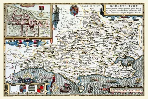
Old County Map of Dorsetshire 1611 by John SpeedA facimile of John Speeds historical map of Dorsetshire originally published for the " Theatre of the Empire of Great Britain", an atlas to accompany " a history of Great Britain"
Old County Map of Cambridgeshire 1648 by Johan Blaeu from the Atlas NovusThis detailed and most attractive reproduction map of Cambridgeshire has been carefully art worked from a scan of an antique original
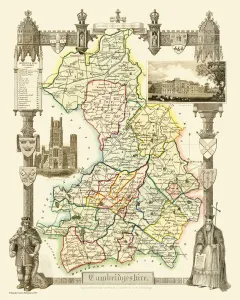
Old County Map of Cambridgeshire 1836 by Thomas MouleThis is a fine decorative reproduction County Map of Cambridgeshire from the First Edition series of Thomas Moule Maps, originally Published in 1836
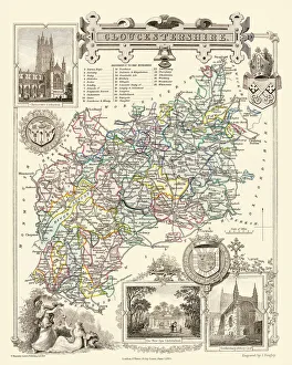
Old County Map of Gloucestershire 1836 by Thomas MouleThis is a fine decorative reproduction County Map of Gloucestershire from the First Edition series of Thomas Moule Maps, originally Published in 1836
Old County Map of Berkshire 1836 by Thomas MouleThis is a fine decorative reproduction County Map of Berkshire from the First Edition series of Thomas Moule Maps, originally Published in 1836
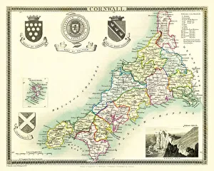
Old County Map of Cornwall 1836 by Thomas MouleThis is a fine decorative reproduction County Map of Cornwall from the First Edition series of Thomas Moule Maps, originally Published in 1836
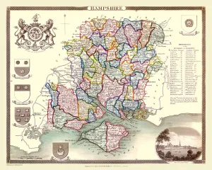
Old County Map of Hampshire 1836 by Thomas MouleThis is a fine decorative reproduction County Map of Hampshire from the First Edition series of Thomas Moule Maps, originally Published in 1836
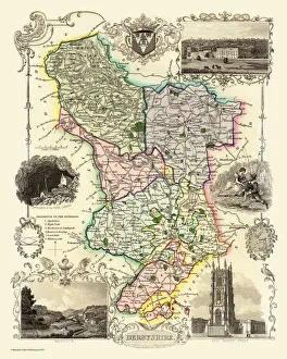
Old County Map of Derbyshire 1836 by Thomas MouleThis is a fine decorative reproduction County Map of Derbyshire from the First Edition series of Thomas Moule Maps, originally Published in 1836
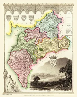
Old County Map of Cumberland 1836 by Thomas MouleThis is a fine decorative reproduction County Map of Cumberland from the First Edition series of Thomas Moule Maps, originally Published in 1836
Old County Map of Oxfordshire 1648 by Johan Blaeu from the Atlas NovusThis detailed and most attractive reproduction map of Oxfordshire has been carefully art worked from a scan of an antique original
Old County Map of Northumberland 1611 by John SpeedA facimile of John Speeds historical map of Northumberland originally published for the " Theatre of the Empire of Great Britain"