mail_outline sales@mediastorehouse.com
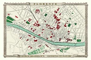
George Bradshaws Plan of Florence, Italy 1896This is a detailed Plan of Florence showing the streets, canals, principal buildings, railways and railway stations. It has been meticulously recreated in colour and republished without
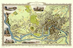
Old Map of Bristol 1851 by John TallisThis 1851 John Tallis map of Bristol shows the new course of the River Avon and the Floating Harbour. At Clifton Down the famous suspension bridge is yet to be constructed
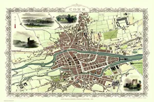
Old Map of Cork Ireland 1851 by John TallisIn this Victorian map of Cork in southern Ireland by John Tallis the North and South channels of the River Lee flow through the centre of the plan with the extensive Barracks dominating
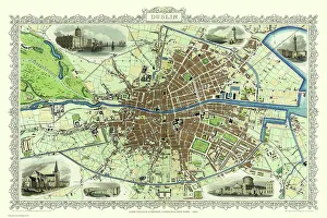
Old Map of Dublin Ireland 1851 by John TallisThis most attractive 19th Century map of Dublin in Southern Ireland by John Tallis 1851 shows all of Dublins districts, the Grand Canal networks and the arrival of the railways
Old Map of Newcastle upon Tyne 1851 by John TallisNewcastle 1851, Gateshead is to the bottom of the John Tallis 1851 plan of Newcastle in Tyne and Wear with the famous High Level Railway crossing the River Tyne into Newcastle Central station
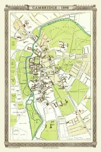
Old Map of Cambridge 1898 from the Royal Atlas by BartholomewA fine very detailed plan of the City of Cambridge from 1898 remastered from an original contained within " The Royal Atlas of England and Wales" ; edited by J.G
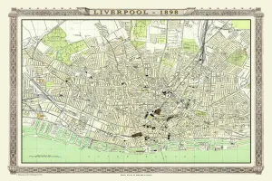
Old Map of Liverpool 1898 from the Royal Atlas by BartholomewA fine very detailed plan of the City of Liverpool remastered from an original contained within " The Royal Atlas of England and Wales" ; edited by J.G
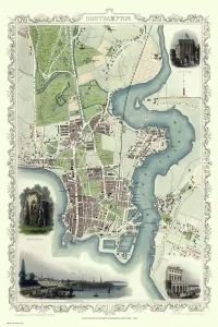
Old Map of Southampton 1851 by John TallisThe River Itchen dominates the 1851 John Tallis plan of Southampton in Hampshire with The Parks covering a great expanse to the top left
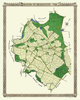
Old Map of The Manor of Erdington in Warwickshire 1760PL064
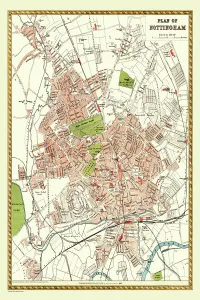
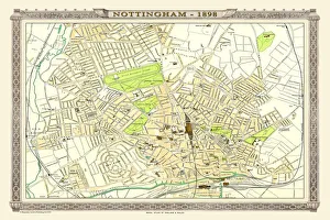
Old Map of Nottingham 1893 from the Comprehensive Gazetteer Atlas of England and WalesThis detailed reproduction plan of Nottingham has been re-worked from an antique originally published in the oComprehensive Gazetteer of England and Waleso 1893
Old Map of Birmingham 1795 by C. PyeJ073
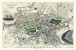
Old Map of Edinburgh 1834 by the S. D. U. KF006
Old Map of Chester 1795 by John StockdaleAn interesting, very detailed, reproduction 18th century street plan of the City of Chester Engraved for and published John Stockdale
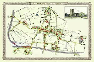
Old Map of the Village of Aldridge in Staffordshire1884PL001
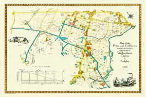
Old Map of the Collieries of Tipton, Sedgley and Wednesbury 1848PL005
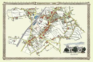
Old Map of the Village of Erdington in the West Midlands 1884PL007
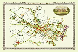
Old Map of Cannock Town in Staffordshire 1886PL004
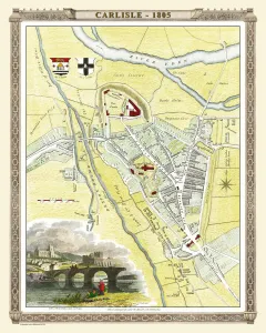
Old Map of Carlisle 1805 by Cole and RoperAn attractive and detailed early 19th century reproduction town plan of Carlisle 1805. First published by Cole and Roper as a finely engraved series of county maps
Old Map of Liverpool 1725J119
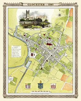
Old Map of Gloucester 1805 by Cole and RoperAn attractive and detailed early 19th century reproduction town plan of Gloucester 1805. First published by Cole and Roper as a finely engraved series of county maps
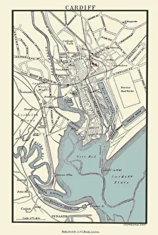
Old Map of Cardiff 1890 by A&C BlackJ133
Old Map of Liverpool 1785 by Surveyed by Charles EyesThis most impressive reproduction map has been completely art worked in full colour from the very rare antique original, large, black and white, detailed plan of Liverpool published by Charles Eyes
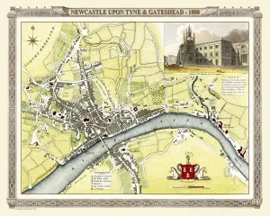
Old Map of Newcastle upon Tyne and Gateshead 1808 by Cole and RoperAn attractive and detailed early 19th century reproduction town plan of Newcastle upon Tyne and Gateshead 1808. First published by Cole and Roper as a finely engraved series of county maps
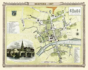
Old Map of Bedford 1807 by Cole and RoperAn attractive and detailed early 19th century reproduction town plan of Bedford, Bedfordshire. First published by Cole and Roper as a finely engraved series of county maps
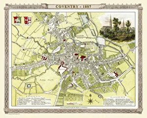
Old Map of Coventry 1807 by Cole and RoperAn attractive and detailed early 19th century reproduction town plan of Coventry 1805. First published by Cole and Roper as a finely engraved series of county maps
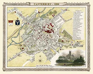
Old Map of Canterbury 1806 by Cole and RoperAn attractive and detailed early 19th century reproduction town plan of Canterbury 1806. First published by Cole and Roper as a finely engraved series of county maps
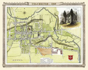
Old Map of Colchester 1805 by Cole and RoperAn attractive and detailed early 19th century reproduction town plan of Colchester 1805. First published by Cole and Roper as a finely engraved series of county maps
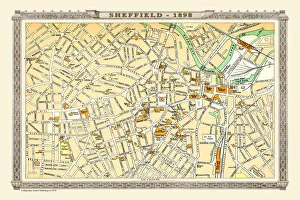
Old Map of Sheffield 1898 from the Royal Atlas by BartholomewA fine very detailed plan of the City of Sheffield remastered from an original contained within " The Royal Atlas of England and Wales" ; edited by J.G
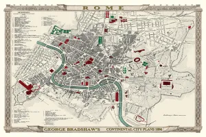
George Bradshaws Plan of Rome, Italy 1896This is a very detailed Plan of Rome showing the streets, canals, principal buildings, railways and railway stations, as well as the many ancient Roman sites
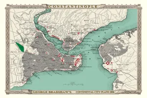
George Bradshaws Plan of Constantinople, Turkey 1896This is a detailed Plan of Constantinople showing the streets, canals, principal buildings, railways and railway stations
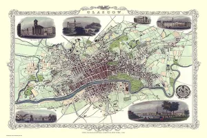
Old Map of Glasgow Scotland 1851 by John TallisThe River Clyde skirts its way through the heart of this famous Scottish City in this wonderful plan by Tallis originally published in 1851. There are six illustrations on the plan
Old Map of Nottingham 1898 from the Royal Atlas by BartholomewA fine very detailed plan of the City of Nottingham remastered from an original contained within " The Royal Atlas of England and Wales" ; edited by J.G
Old Map of Manchester 1851 by John TallisThis John Tallis Victorian map, 1851, of Manchester in Lancashire covers the districts of Salford, Manchester, Ardwick, Chorlton and Hulme
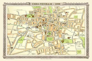
Old Map of Central Cheltenham 1898 from the Royal Atlas by BartholomewA fine very detailed town plan of Cheltenham from 1898 remastered from an original contained within " The Royal Atlas of England and Wales" ; edited by J.G
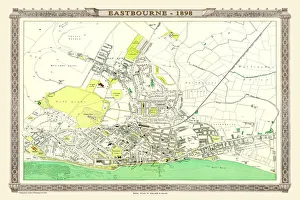
Old Map of Eastbourne 1898 from the Royal Atlas by BartholomewA fine very detailed plan of the Seaside Town of Eastbourne from 1898 remastered from an original contained within " The Royal Atlas of England and Wales" ; edited by J.G
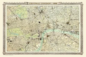
Old Map of Central London 1898 from the Royal Atlas by BartholomewA fine very detailed plan of Central London from 1898 remastered from an original contained within " The Royal Atlas of England and Wales" ; edited by J.G
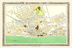
Old Map of Blackpool 1898 from the Royal Atlas by BartholomewA fine very detailed plan of the Town of Blackpool remastered from an original contained within " The Royal Atlas of England and Wales" ; edited by J.G
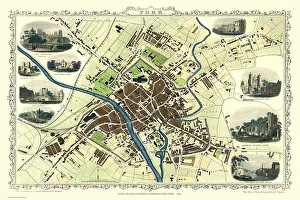
Old Map of York 1851 by John TallisThe River Ouse flows through the famous City of York, already its buildings are spreading outside its ancient walls. The 1851 John Tallis plan is illustrated with views of The Minster, Walmgate Bar
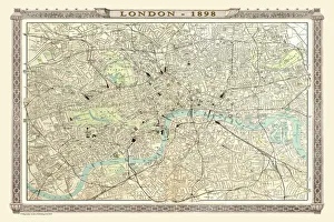
Old Map of London 1898 from the Royal Atlas by BartholomewA fine very detailed plan of the City of London remastered from an original contained within " The Royal Atlas of England and Wales" ; edited by J.G
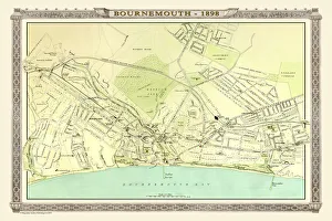
Old Map of Bournemouth 1898 from the Royal Atlas by BartholomewA fine very detailed plan of the Seaside Town of Bournemouth from 1898 remastered from an original contained within " The Royal Atlas of England and Wales" ; edited by J.G
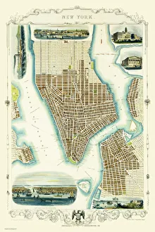
Old Map of New York United States of America 1851 by John TallisThis is a most attractive yet detailed plan 1851 by John Tallis of New York and districts of Jersey, Panovia, Hoboken, Brooklyn and Williamsburgh in the U.S.A
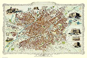
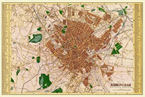
Old Map of Birmingham 1893 from the Comprehensive Gazetteer Atlas of England and WalesThis detailed reproduction plan of Birmingham has been re-worked from an antique originally published in the oComprehensive Gazetteer of England and Waleso 1893
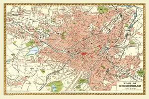
Old Map of Birmingham 1883==
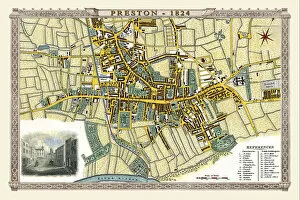
Old Map of Preston 1824 by Edward BainesThis is a fine detailed reproduction Map of The City of Preston from the First Edition series of Thomas Moule Maps, originally Published in 1836
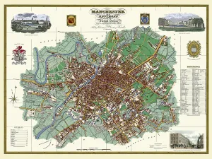
Old Map of Manchester and its Environs 1824 by William SwireJ128
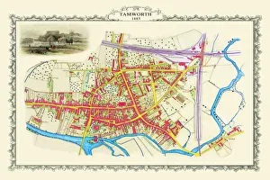
Old Map of the Town of Tamworth in Staffordshire 1885PL018
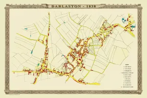
Old Map of the Town of Darlaston in the West Midlands 1838PL39
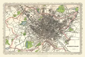
Old Map of Birmingham 1866 by Fullarton & CoThis detailed reproduction plan of Birmingham has been re-worked from an antique originally published in the 1860,s by Archibold Fullarton & Company