mail_outline sales@mediastorehouse.com
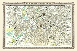
Old Map of Manchester and Salford 1898 from the Royal Atlas by BartholomewA fine very detailed plan of the City of Manchester and Salford remastered from an original contained within " The Royal Atlas of England and Wales" ; edited by J.G
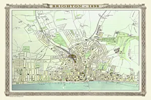
Old Map of Brighton 1898 from the Royal Atlas by BartholomewA fine very detailed plan of the Seaside Town of Brighton from 1898 remastered from an original contained within " The Royal Atlas of England and Wales" ; edited by J.G
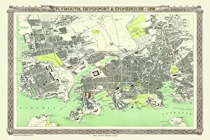
Old Map of Plymouth, Devonport and Stonehouse 1898 from the Royal Atlas by BartholomewA fine very detailed plan of the Port City of Plymouth with Devonport and Stonehouse, remastered from an original contained within " The Royal Atlas of England and Wales" ; edited by J.G
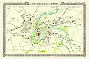
Old Map of Durham 1898 from the Royal Atlas by BartholomewA fine very detailed plan of the City of Durham remastered from an original contained within " The Royal Atlas of England and Wales" ; edited by J.G
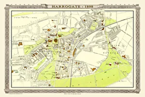
Old Map of Harrogate 1898 from the Royal Atlas by BartholomewA fine very detailed town plan of Harrogate from 1898 remastered from an original contained within " The Royal Atlas of England and Wales" ; edited by J.G
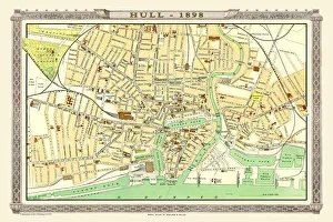
Old Map of Hull 1898 from the Royal Atlas by BartholomewA fine very detailed plan of the City of Hull remastered from an original contained within " The Royal Atlas of England and Wales" ; edited by J.G
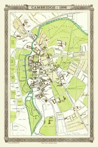
Old Map of Cambridge 1898 from the Royal Atlas by BartholomewA fine very detailed plan of the City of Cambridge from 1898 remastered from an original contained within " The Royal Atlas of England and Wales" ; edited by J.G
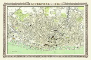
Old Map of Liverpool 1898 from the Royal Atlas by BartholomewA fine very detailed plan of the City of Liverpool remastered from an original contained within " The Royal Atlas of England and Wales" ; edited by J.G
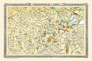
Old Map of Sheffield 1898 from the Royal Atlas by BartholomewA fine very detailed plan of the City of Sheffield remastered from an original contained within " The Royal Atlas of England and Wales" ; edited by J.G
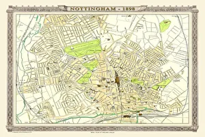
Old Map of Nottingham 1898 from the Royal Atlas by BartholomewA fine very detailed plan of the City of Nottingham remastered from an original contained within " The Royal Atlas of England and Wales" ; edited by J.G
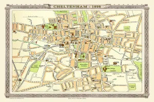
Old Map of Central Cheltenham 1898 from the Royal Atlas by BartholomewA fine very detailed town plan of Cheltenham from 1898 remastered from an original contained within " The Royal Atlas of England and Wales" ; edited by J.G
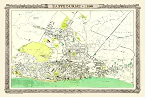
Old Map of Eastbourne 1898 from the Royal Atlas by BartholomewA fine very detailed plan of the Seaside Town of Eastbourne from 1898 remastered from an original contained within " The Royal Atlas of England and Wales" ; edited by J.G
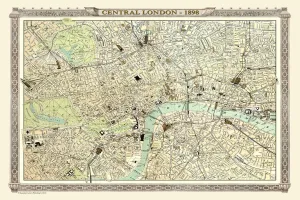
Old Map of Central London 1898 from the Royal Atlas by BartholomewA fine very detailed plan of Central London from 1898 remastered from an original contained within " The Royal Atlas of England and Wales" ; edited by J.G
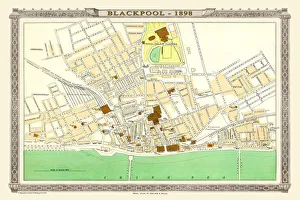
Old Map of Blackpool 1898 from the Royal Atlas by BartholomewA fine very detailed plan of the Town of Blackpool remastered from an original contained within " The Royal Atlas of England and Wales" ; edited by J.G
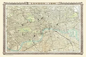
Old Map of London 1898 from the Royal Atlas by BartholomewA fine very detailed plan of the City of London remastered from an original contained within " The Royal Atlas of England and Wales" ; edited by J.G
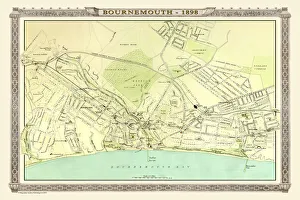
Old Map of Bournemouth 1898 from the Royal Atlas by BartholomewA fine very detailed plan of the Seaside Town of Bournemouth from 1898 remastered from an original contained within " The Royal Atlas of England and Wales" ; edited by J.G
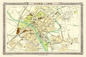
Old Map of York 1898 from the Royal Atlas by BartholomewA fine very detailed plan of the City of York remastered from an original contained within " The Royal Atlas of England and Wales" ; edited by J.G
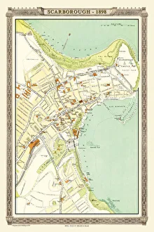
Old Map of Scarborough 1898 from the Royal Atlas by BartholomewA fine very detailed plan of the Seaside Town of Scarborough from 1898 remastered from an original contained within " The Royal Atlas of England and Wales" ; edited by J.G
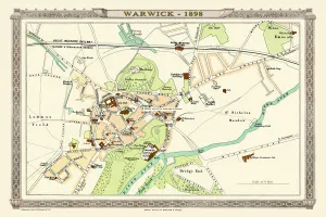
Old Map of Warwick 1898 from the Royal Atlas by BartholomewA fine very detailed plan of the City of Warwick remastered from an original contained within " The Royal Atlas of England and Wales" ; edited by J.G
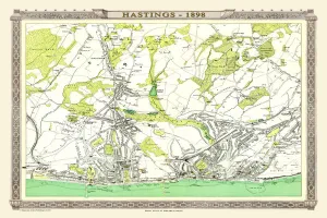
Old Map of Hastings 1898 from the Royal Atlas by BartholomewA fine very detailed town plan of Hastings from 1898 remastered from an original contained within " The Royal Atlas of England and Wales" ; edited by J.G
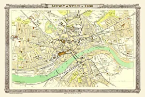
Old Map of Newcastle 1898 from the Royal Atlas by BartholomewA fine very detailed plan of the City of Newcastle remastered from an original contained within " The Royal Atlas of England and Wales" ; edited by J.G
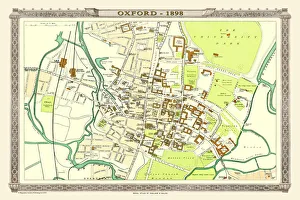
Old Map of Oxford 1898 from the Royal Atlas by BartholomewA fine very detailed plan of the City of Oxford remastered from an original contained within " The Royal Atlas of England and Wales" ; edited by J.G
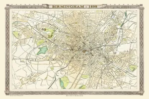
Old Map of Birmingham 1898 from the Royal Atlas by BartholomewA fine very detailed plan of the City of Birmingham remastered from an original contained within " The Royal Atlas of England and Wales" ; edited by J.G
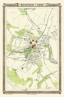
Old Map of Buxton 1898 from the Royal Atlas by BartholomewA fine very detailed plan of the Spa Town of Buxton from 1898 remastered from an original contained within " The Royal Atlas of England and Wales" ; edited by J.G