mail_outline sales@mediastorehouse.com
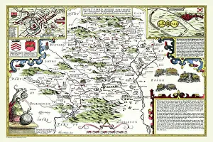
Old County Map of Hertfordshire 1611 by John SpeedA facimile of John Speeds historical map of Hertfordshire originally published for the " Theatre of the Empire of Great Britain"
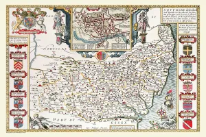
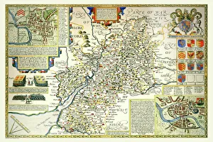
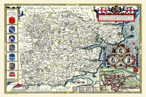
Old County Map of Suffolk 1611 by John SpeedA facimile of John Speeds historical map of Norfolk originally published for the " Theatre of the Empire of Great Britain", an atlas to accompany " a history of Great Britain"
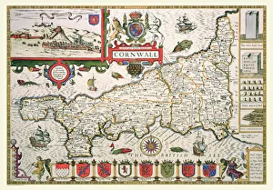
Old County Map of Cornwall 1611 by John SpeedA facimile of John Speeds historical map of Cornwall originally published for the " Theatre of the Empire of Great Britain", an atlas to accompany " a history of Great Britain"
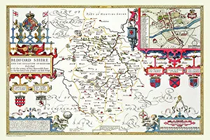
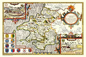
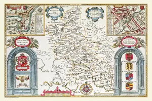
Old County Map of Bedfordshire 1611 by John SpeedA fine reproduction of John Speeds historical map of Bedfordshire originally published for the " Theatre of the Empire of Great Britain"
Old County Map of Derbyshire 1611 by John SpeedA facimile of John Speeds historical map of Derbyshire originally published for the " Theatre of the Empire of Great Britain", an atlas to accompany " a history of Great Britain"
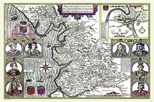
Old County Map of Lancashire 1611 by John SpeedA facimile of John Speeds historical map of Lancashire published for the " Theatre of the Empire of Great Britain", an atlas to accompany " a history of Great Britain"
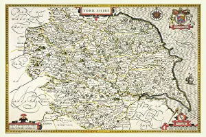
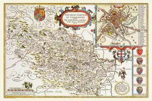
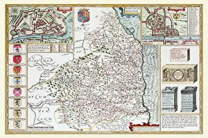
Old County Map of Yorkshire 1611 by John SpeedA facimile of John Speeds historical map of Yorkshire originally published for the " Theatre of the Empire of Great Britain", an atlas to accompany " a history of Great Britain"
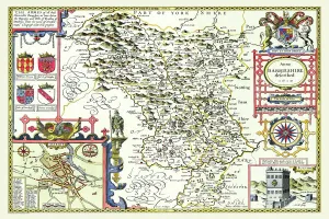
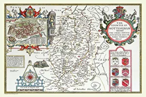
Old County Map of Nottinghamshire 1611 by John SpeedA facimile of John Speeds historical map of Nottinghamshire originally published for the " Theatre of the Empire of Great Britain"
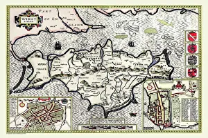
Old Map of The Isle of Wight 1611 by John SpeedA facimile of John Speeds historical map of the Isle of Wight originally published for the " Theatre of the Empire of Great Britain"
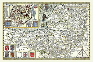
Old County Map of Somersetshire 1611 by John SpeedA facimile of John Speeds historical map of Somersetshire originally published for the " Theatre of the Empire of Great Britain"
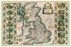
Old Map of Anglo Saxon Britain by John SpeedA facimile of John Speeds historical map of the Saxon Heptarchy originally published for the " Theatre of the Empire of Great Britain"
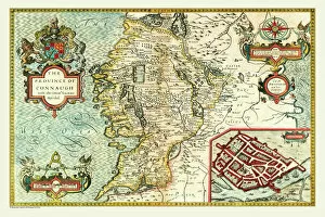
Old Map of The Province of Connacht, Ireland 1611 by John SpeedA facimile of John Speeds historical map of the Province of Connacht originally published for the " Theatre of the Empire of Great Britain"
Old County Map of Yorkshire West Riding 1611 by John SpeedA facimile of John Speeds historical map of Yorkshire West Riding originally published for the " Theatre of the Empire of Great Britain"
Old County Map of Gloucestershire 1611 by John SpeedA facimile of John Speeds historical map of Gloucestershire originally published for the " Theatre of the Empire of Great Britain"
Old County Map of Cambridgeshire 1611 by John SpeedA facimile of John Speeds historical map of Cambridgeshire originally published for the " Theatre of the Empire of Great Britain"
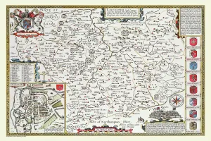
Old County Map of Leicestershire 1611 by John SpeedA facimile of John Speeds historical map of Leicestershire originally published for the " Theatre of the Empire of Great Britain"
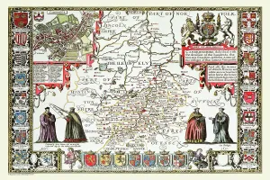
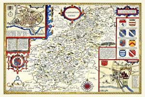
Old County Map of Northamptonshire 1611 by John SpeedA facimile of John Speeds historical map of Northamptonshire originally published for the " Theatre of the Empire of Great Britain"
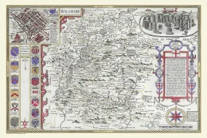
OldCounty Map of Wiltshire 1611 by John SpeedA facimile of John Speeds historical map of Wiltshire published for the " Theatre of the Empire of Great Britain", an atlas to accompany " a history of Great Britain"
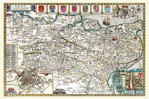
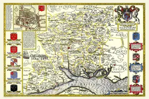
Old County Map of Kent 1611 by John SpeedA facimile of John Speeds historical map of Kent originally published for the " Theatre of the Empire of Great Britain", an atlas to accompany " a history of Great Britain"
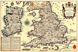
Old Map of The Invasions of England and Ireland by John SpeedA facimile of John Speeds historical map of the Invasions of England and Ireland originally published for the " Theatre of the Empire of Great Britain"
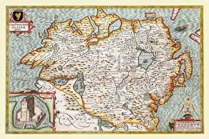
Old Map of The Province of Ulster 1611 by John SpeedA facimile of John Speeds historical map of the Province of Ulster originally published for the " Theatre of the Empire of Great Britain"
Old County Map of Pembrokeshire, Wales 1611 by John SpeedA facimile of John Speeds historical map of Pembrokeshire originally published for the " Theatre of the Empire of Great Britain"
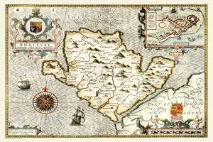
Old Map of The Isle of Anglesey, Wales 1611 by John SpeedA facimile of John Speeds historical map of Anglesey originally published for the " Theatre of the Empire of Great Britain", an atlas to accompany " a history of Great Britain"
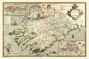
Old Map of The Province of Munster, Ireland 1611 by John SpeedA facimile of John Speeds historical map of the Province of Munster originally published for the " Theatre of the Empire of Great Britain"
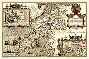
Old County Map of Caernarvonshire, Wales 1611 by John SpeedA facimile of John Speeds historical map of Caernarvonshire originally published for the " Theatre of the Empire of Great Britain"
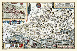
Old County Map of Dorsetshire 1611 by John SpeedA facimile of John Speeds historical map of Dorsetshire originally published for the " Theatre of the Empire of Great Britain", an atlas to accompany " a history of Great Britain"
Old County Map of Northumberland 1611 by John SpeedA facimile of John Speeds historical map of Northumberland originally published for the " Theatre of the Empire of Great Britain"
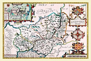
Old County Map of Carmarthenshire 1611 by John SpeedA facimile of John Speeds historical map of Carmarthenshire originally published for the " Theatre of the Empire of Great Britain"
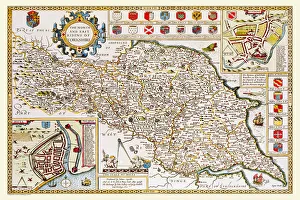
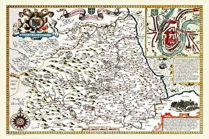
Old County Map of Yorkshire North and East Riding 1611 by John SpeedA facimile of John Speeds historical map of Yorkshire North and East Riding originally published for the " Theatre of the Empire of Great Britain"
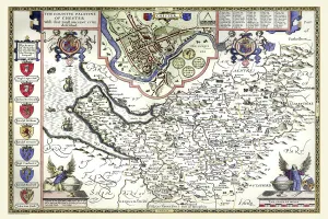
Old County Map of Cheshire 1611 by John SpeedA facimile of John Speeds historical map of Cheshire originally published for the " Theatre of the Empire of Great Britain", an atlas to accompany " a history of Great Britain"
Old County Map of Buckinghamshire 1611 by John SpeedA fine reproduction of John Speeds historical map of Buckinghamshire originally published for the " Theatre of the Empire of Great Britain"
Old County Map of Sussex 1611 by John SpeedA facimile of John Speeds historical map of Sussex originally published for the " Theatre of the Empire of Great Britain", an atlas to accompany " a history of Great Britain"
Old County Map of Durham 1611 by John SpeedA facimile of John Speeds historical map of Durham originally published for the " Theatre of the Empire of Great Britain", an atlas to accompany " a history of Great Britain"
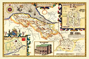
Old County Map of Flintshire 1611 by John SpeedA facimile of John Speeds historical map of Flintshire originally published for the " Theatre of the Empire of Great Britain", an atlas to accompany " a history of Great Britain"
Old Map of The Province of Leinster, Ireland 1611 by John SpeedA facimile of John Speeds historical map of the Province of Leinster originally published for the " Theatre of the Empire of Great Britain"
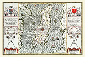
Old Map of The Isle of Man 1611 by John SpeedA facimile of John Speeds historical map of the Isle of Man originally published for the " Theatre of the Empire of Great Britain"
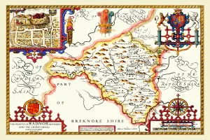
Old County Map of Radnorshire, Wales 1611 by John SpeedA facimile of John Speeds historical map of Radnorshire originally published for the " Theatre of the Empire of Great Britain", an atlas to accompany " a history of Great Britain"
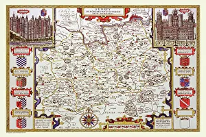
Old County Map of Essex 1611 by John SpeedA facimile of John Speeds historical map of Essex originally published for the " Theatre of the Empire of Great Britain", an atlas to accompany " a history of Great Britain"
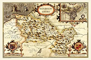
Old County Map of Denbighshire 1611 by John SpeedA facimile of John Speeds historical map of Denbighshire originally published for the " Theatre of the Empire of Great Britain", an atlas to accompany " a history of Great Britain"
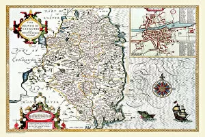
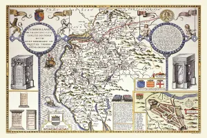
Old County Map of Cumberland 1611 by John SpeedA facimile of John Speeds historical map of Cumberland originally published for the " Theatre of the Empire of Great Britain", an atlas to accompany " a history of Great Britain"
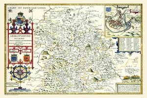
Old County Map of Shropshire 1611 by John SpeedA facimile of John Speeds historical map of Shropshire originally published for the " Theatre of the Empire of Great Britain", an atlas to accompany " a history of Great Britain"
Old County Map of Staffordshire 1611 by John SpeedA facimile of John Speeds historical map of Staffordshire originally published for the " Theatre of the Empire of Great Britain"
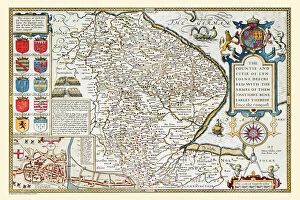
Old County Map of Lincolnshire 1611 by John SpeedA facimile of John Speeds historical map of Lincolnshire originally published for the " Theatre of the Empire of Great Britain", an atlas to accompany " a history of Great Britain"
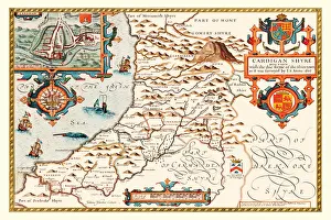
Old County Map of Cardiganshire 1611 by John SpeedA facimile of John Speeds historical map of Cardiganshire originally published for the " Theatre of the Empire of Great Britain"
Old County Map of Hampshire 1611 by John SpeedA facimile of John Speeds historical map of Hampshire originally published for the " Theatre of the Empire of Great Britain", an atlas to accompany " a history of Great Britain"
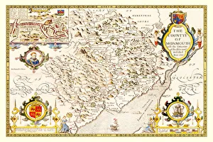
Old County Map of Monmouthshire 1611 by John SpeedA facimile of John Speeds historical map of Monmouthshire originally published for the " Theatre of the Empire of Great Britain"
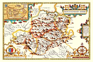
Old County Map of Montgomeryshire 1611 by John SpeedA facimile of John Speeds historical map of Montgomeryshire originally published for the " Theatre of the Empire of Great Britain"
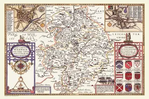
Old County Map of Warwickshire 1611 by John SpeedA facimile of John Speeds historical map of Warwickshire originally published for the " Theatre of the Empire of Great Britain", an atlas to accompany " a history of Great Britain"