Home > Maps of the Americas > Maps of Central and South America
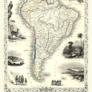
Old Map of South America 1852 by Henry George Collins

![]()
Wall Art and Photo Gifts from MapSeeker
Old Map of South America 1852 by Henry George Collins
This is a finely detailed map of South America remastered from a rare Atlas of the World published in 1852 by Henry George Collins. Although these Henry Collins produced maps of the highest quality in his time unfortunately not the same could be said in terms of his business success. His maps were later obtained by the famous Stanford Map Company and used in their publications
Media ID 20347424
© Mapseeker Publishing Ltd
Collins Collins Atlas Collins Atlas Map Collins Map Continental Map Old Continental Map
MADE IN THE UK
Safe Shipping with 30 Day Money Back Guarantee
FREE PERSONALISATION*
We are proud to offer a range of customisation features including Personalised Captions, Color Filters and Picture Zoom Tools
SECURE PAYMENTS
We happily accept a wide range of payment options so you can pay for the things you need in the way that is most convenient for you
* Options may vary by product and licensing agreement. Zoomed Pictures can be adjusted in the Basket.