Home > Maps of the Artic and Antarctic > The Arctic
Tote Bag : Old Map of The North Pole "Septentrionalium Terrarum descriptio"originally Published by Johannes Cloppenburg 1632


![]()
Home Decor from MapSeeker
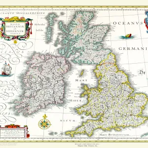
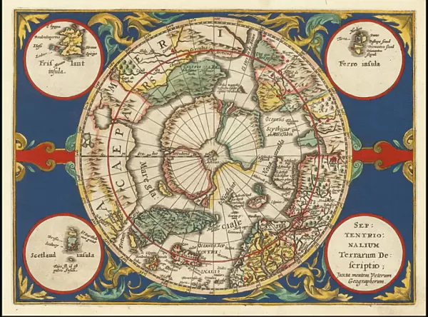
Old Map of The North Pole "Septentrionalium Terrarum descriptio"originally Published by Johannes Cloppenburg 1632
A striking reproduction from Cloppenburgs reduced size edition of Mercators map of the North Polar regions, the first separate map of the North Polar Regions. Gerard Mercator was the first cartographer to create a polar projection of the earth. This map, the first separate map devoted to the Arctic regions, is drawn from an inset on Mercators world map of 1569. The map is extended to 60 degrees, to incorporate the recent explorations in search of the North West and North East Passages by Frobisher and Davis
Media ID 20347045
Canvas Tote Bag
Our tote bags are made from soft, durable, poly-poplin fabric and include a one inch (2.5cm) black strap for easy carrying on your shoulder. All seams are double-stitched for added durability. Each tote bag is machine-washable in cold water and is printed on both sides using the same image. Approximate size of bag is 50x33cm (20"x13")
Our tote bags are made from soft durable fabric and include a strap for easy carrying
Estimated Product Size is 50cm x 32.7cm (19.7" x 12.9")
These are individually made so all sizes are approximate
MADE IN THE UK
Safe Shipping with 30 Day Money Back Guarantee
FREE PERSONALISATION*
We are proud to offer a range of customisation features including Personalised Captions, Color Filters and Picture Zoom Tools
SECURE PAYMENTS
We happily accept a wide range of payment options so you can pay for the things you need in the way that is most convenient for you
* Options may vary by product and licensing agreement. Zoomed Pictures can be adjusted in the Cart.