Home > Maps from the British Isles > British Coastal Surveys PORTFOLIO
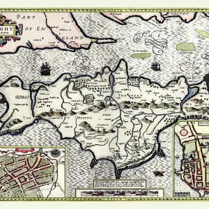
Early Coastal Survey Map of the Isle of Wight, Spithead and Portsmouth Harbour 1794

![]()
Wall Art and Photo Gifts from MapSeeker
Early Coastal Survey Map of the Isle of Wight, Spithead and Portsmouth Harbour 1794
This is a colour reproduction of the attractive coastal chart of the Isle of Wight, Spithead and Portsmouth Harbour originally published in 1794 by Jos Avery
Media ID 20347509
FEATURES IN THESE COLLECTIONS
> Maps from the British Isles
> British Coastal Surveys PORTFOLIO
> Maps from the British Isles
> Islands around Britain PORTFOLIO
MADE IN THE UK
Safe Shipping with 30 Day Money Back Guarantee
FREE PERSONALISATION*
We are proud to offer a range of customisation features including Personalised Captions, Color Filters and Picture Zoom Tools
SECURE PAYMENTS
We happily accept a wide range of payment options so you can pay for the things you need in the way that is most convenient for you
* Options may vary by product and licensing agreement. Zoomed Pictures can be adjusted in the Basket.