Home > Maps of Europe > Maps of Austria PORTFOLIO
Photographic Print : George Bradshaws Plan of Vienna, Austria 1896

![]()
Photo Prints from MapSeeker
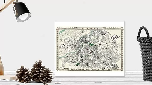
George Bradshaws Plan of Vienna, Austria 1896
This is a very detailed Plan of Vienna, which features streets, canals, principal buildings, railways and railway stations. The plan has been meticulously recreated in colour and republished without and fold creases by Mapseeker, from a rare antique original black and white fold up tourist city map. The 29 that were originally published as fold up maps featuring the principal cities of Europe are now rare, yet popular at their time among those who could then explore Europe by railway for the first time
Media ID 20348144
© Mapseeker Publishing Ltd
Bradshaw City Map Bradshaw City Plan Bradshaw Map Europe City Europe City Plan European City Map European City Plan Historic Map Old Town Plan
10"x8" (25x20cm) Photo Print
Printed on archival quality paper for unrivalled stable artwork permanence and brilliant colour reproduction with accurate colour rendition and smooth tones. Printed on professional 234gsm Fujifilm Crystal Archive DP II paper. 10x8 for landscape images, 8x10 for portrait images.
Our Photo Prints are in a large range of sizes and are printed on Archival Quality Paper for excellent colour reproduction and longevity. They are ideal for framing (our Framed Prints use these) at a reasonable cost. Alternatives include cheaper Poster Prints and higher quality Fine Art Paper, the choice of which is largely dependant on your budget.
Estimated Image Size (if not cropped) is 25.4cm x 16.9cm (10" x 6.7")
Estimated Product Size is 25.4cm x 20.3cm (10" x 8")
These are individually made so all sizes are approximate
Artwork printed orientated as per the preview above, with landscape (horizontal) orientation to match the source image.
MADE IN THE UK
Safe Shipping with 30 Day Money Back Guarantee
FREE PERSONALISATION*
We are proud to offer a range of customisation features including Personalised Captions, Color Filters and Picture Zoom Tools
SECURE PAYMENTS
We happily accept a wide range of payment options so you can pay for the things you need in the way that is most convenient for you
* Options may vary by product and licensing agreement. Zoomed Pictures can be adjusted in the Cart.