Home > Old Railway and Canal Map Collection > Old Railway Maps PORTFOLIO
Old Map of the Routes and Stations of the Great Western Railway 1927

![]()
Wall Art and Photo Gifts from MapSeeker
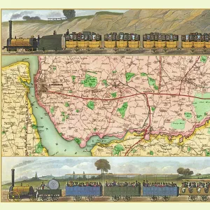
Old Map of the Routes and Stations of the Great Western Railway 1927
Completely remastered from an original fold up map published in 1927, this reproduction map shows all the routes and stations of the Great Western Railway. To the top right a picture of an Express Passenger Locomotive " King George IV" bursting from a tunnel has been added; the map also shows sections in more detail of the districts of Birmingham and South Wales. The map also details the ferry crossing routes from mainland England and Wales
Media ID 20347410
© Mapseeker Publishing Ltd
Historic Railway Map Old Railway Map Railway Map
MADE IN THE USA
Safe Shipping with 30 Day Money Back Guarantee
FREE PERSONALISATION*
We are proud to offer a range of customisation features including Personalised Captions, Color Filters and Picture Zoom Tools
SECURE PAYMENTS
We happily accept a wide range of payment options so you can pay for the things you need in the way that is most convenient for you
* Options may vary by product and licensing agreement. Zoomed Pictures can be adjusted in the Cart.