Home > Pictorial Maps and Pictorial History > Pictorial History Maps PORTFOLIO
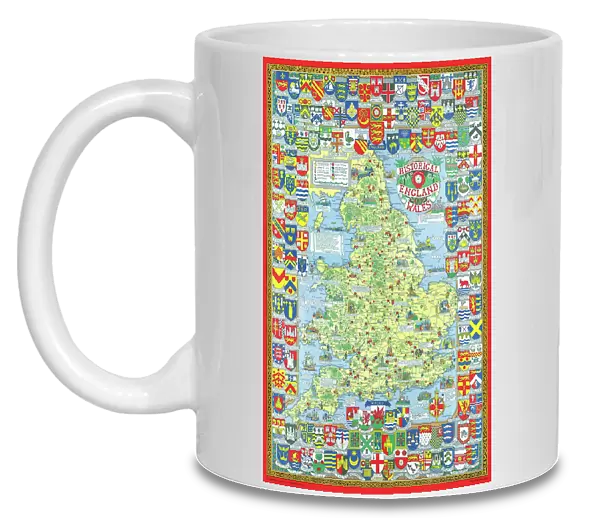
Photo Mug : Pictorial History Map of England and Wales 1963


![]()
Home Decor from MapSeeker
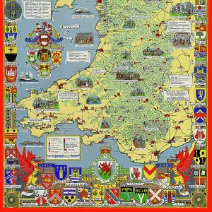
Pictorial History Map of England and Wales 1963
This is a wonderful map illustrating the history of England and Wales drawn by Leslie Bullock and published in 1963 by Collins Bartholomew as a fold up map. Now re-digitized and re-published by Mapseeker in association with the Collins Bartholomew Archive, the map covers all of England and Wales with historical locations and events illustrated pictorially in the form of charming cartoon vignettes. The map is surrounded by the armorial crests of the most important cities of England and Wales
Media ID 20348231
Photo Mug
A personalised photo mug blends sentimentality with functionality, making an ideal gift for cherished loved ones, close friends, or valued colleagues. Preview may show both sides of the same mug.
Elevate your coffee or tea experience with our premium white ceramic mug. Its wide, comfortable handle makes drinking easy, and you can rely on it to be both microwave and dishwasher safe. Sold in single units, preview may show both sides of the same mug so you can see how the picture wraps around.
Mug Size is 9.5cm high x 8cm diameter (3.7" x 3.1")
These are individually made so all sizes are approximate
FEATURES IN THESE COLLECTIONS
> Maps from the British Isles
> England with Wales PORTFOLIO
> Pictorial Maps and Pictorial History
> Pictorial History Maps PORTFOLIO
MADE IN THE UK
Safe Shipping with 30 Day Money Back Guarantee
FREE PERSONALISATION*
We are proud to offer a range of customisation features including Personalised Captions, Color Filters and Picture Zoom Tools
SECURE PAYMENTS
We happily accept a wide range of payment options so you can pay for the things you need in the way that is most convenient for you
* Options may vary by product and licensing agreement. Zoomed Pictures can be adjusted in the Cart.