Home > British Town And City Plans > English & Welsh PORTFOLIO
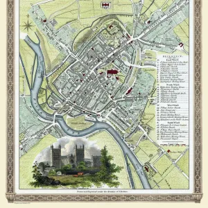
Old Map of Exeter by Braun and Hogenburg 1618

![]()
Wall Art and Photo Gifts from MapSeeker
Old Map of Exeter by Braun and Hogenburg 1618
A fine reproduction of Frans Hogenbergs city plan of Exeter originally published as one of the many in the city atlas which was intended to be a companion to the earlier Theatrum Orbis Terrarum entitled Civitates Orbis Terrarum which and edited by Georg Braun. Comprising six volumes published between 1572 and 1618 they contained more than 500 plans including this plan of Exeter in Vol.6 dated 1618
Media ID 20346939
MADE IN THE UK
Safe Shipping with 30 Day Money Back Guarantee
FREE PERSONALISATION*
We are proud to offer a range of customisation features including Personalised Captions, Color Filters and Picture Zoom Tools
SECURE PAYMENTS
We happily accept a wide range of payment options so you can pay for the things you need in the way that is most convenient for you
* Options may vary by product and licensing agreement. Zoomed Pictures can be adjusted in the Basket.