mail_outline sales@mediastorehouse.com
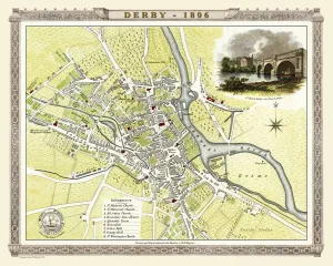
Old Map of Derby 1806 by Cole and RoperAn attractive and detailed early 19th century reproduction town plan of Derby 1805. First published by Cole and Roper as a finely engraved series of county maps
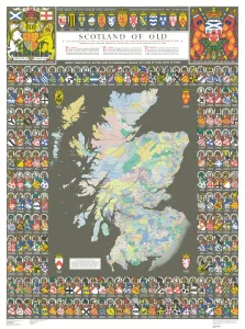
The Historic Map of Scotland "Scotland of Old"Now republished at its original full size, the Scotland of Old Map, also known as the Bartholomew Clan Map of Scotland, features " The Lands", " The Arms"
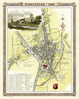
Old Map of Worcester 1808 by Cole and RoperAn attractive and detailed early 19th century reproduction town plan of Worcester 1808. First published by Cole and Roper as a finely engraved series of county maps
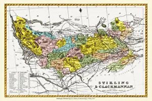
Old County Map of Stirling and Clackmannan Scotland 1847 by A&C BlackA finely detailed facimile remastered in full colour from an antique original map of Stirling and Clackmannan featured in A&C Blacks Atlas of 1847
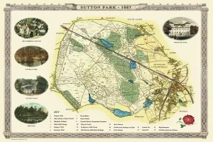
Old Map of Sutton Park near Sutton Coldfield 1885PL017
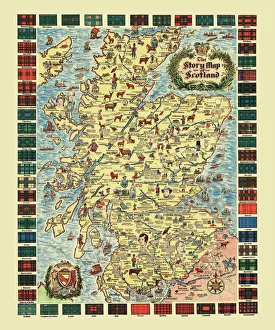
Pictorial Story Map of ScotlandThis map has been remastered from an original published by Colortext, it was one of a series they labelled aeStory MapAE. It combines pictorial images
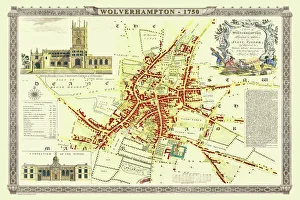
Old Map of Wolverhampton 1750 by Isaac TaylorJ066
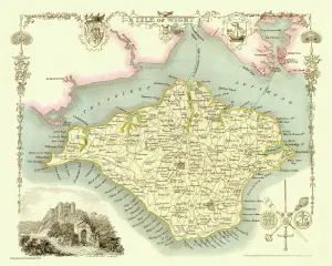
Old Map of The Isle of Wight 1836 by Thomas MouleThis is a fine decorative reproduction Map of The Isle of Wight from the First Edition series of Thomas Moule Maps, originally Published in 1836
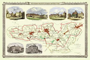
Old Map of Stoke on Trent and the Potteries 1831G148
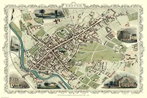
Old Map of Exeter 1851 by John TallisThe River Exe skirts the South West of this plan of Exeter in Devon by John Tallis 1851 with the Exe Bridge providing direct access through the heart of Exeter
Old Map of the City of Cambridge 1836 by Thomas MouleThis is a fine decorative reproduction Map of The City of Cambridge from the First Edition series of Thomas Moule Maps, originally Published in 1836
Old Map of Cheltenham 1825 by Griffith sFine reproduction in full colour of Griffiths new historical description of Cheltenham and its vicinity originally published in 1825
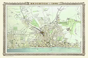
Old Map of Brighton 1898 from the Royal Atlas by BartholomewA fine very detailed plan of the Seaside Town of Brighton from 1898 remastered from an original contained within " The Royal Atlas of England and Wales" ; edited by J.G
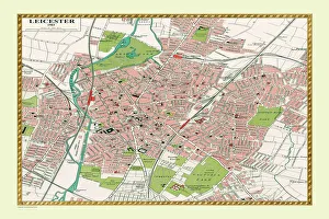
Old Map of Leicester 1903J105
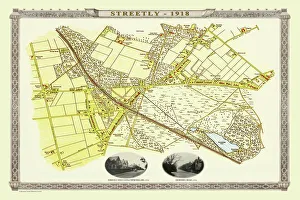
Old Map of the Village of Streetly near Sutton Coldfield 1918PL015
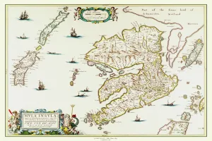
Old Map of the Isle of Islay Scotland 1654 by Johan Blaeu from the Atlas NovusThis detailed and most attractive reproduction map of The Isle of Islay has been carefully art worked from a scan of an antique original
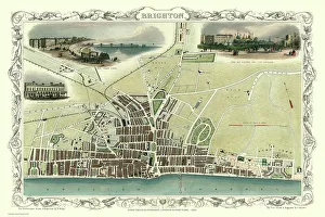
Old Map of Brighton 1851 by John TallisA most attractive Victorian plan of Brighton in Sussex by John Tallis 1851 showing its famous Chain Pier reaching out into the English Channel
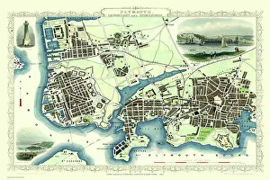
Old Map of Plymouth Devonport and Stonehouse 1851 by John TallisAn attractive Victorian plan of Plymouth in Devon by John Tallis 1851, with Morice Town, Higher Stoke, Stoke, Devonport and Stonehouse
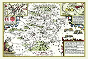
Old County Map of Hertfordshire 1611 by John SpeedA facimile of John Speeds historical map of Hertfordshire originally published for the " Theatre of the Empire of Great Britain"
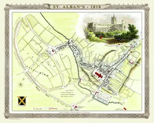
Old Map of St Albans 1810 by Cole and RoperAn attractive and detailed early 19th century reproduction town plan of St Albans 1810. First published by Cole and Roper as a finely engraved series of county maps
Old Map of the Isle of Mull Scotland 1654 by Johan Blaue from the Atlas NovusThis detailed and most attractive reproduction map of The Isle of Mull has been carefully art worked from a scan of an antique original
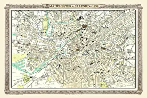
Old Map of Manchester and Salford 1898 from the Royal Atlas by BartholomewA fine very detailed plan of the City of Manchester and Salford remastered from an original contained within " The Royal Atlas of England and Wales" ; edited by J.G
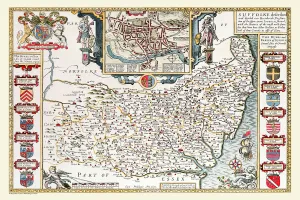
Old County Map of Suffolk 1611 by John SpeedA facimile of John Speeds historical map of Norfolk originally published for the " Theatre of the Empire of Great Britain", an atlas to accompany " a history of Great Britain"
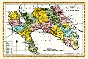
Old County Map of Wigtown Scotland 1847 by A&C BlackA finely detailed facimile remastered in full colour from an antique original map of Wigtownshire featured in A&C Blacks Atlas of 1847
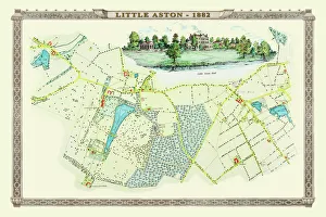
Old Map of the Village of Little Aston in the West Midlands 1886PL009
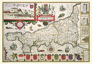
Old County Map of Cornwall 1611 by John SpeedA facimile of John Speeds historical map of Cornwall originally published for the " Theatre of the Empire of Great Britain", an atlas to accompany " a history of Great Britain"
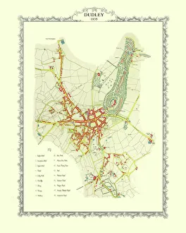
Old Map of Dudley 1835J037
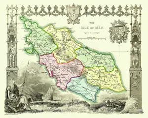
Old Map of The Isle of Man 1836 by Thomas MouleThis is a fine decorative reproduction Map of The Isle of Man from the First Edition series of Thomas Moule Maps, originally Published in 1836
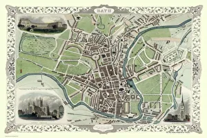
Old Map of Bath 1851 by John TallisThis is a splendid Victorian map by John Tallis 1851 of the historic Spa City of Bath in North East Somerset nestled between a bend on the River Avon
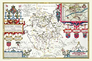
Old County Map of Bedfordshire 1611 by John SpeedA fine reproduction of John Speeds historical map of Bedfordshire originally published for the " Theatre of the Empire of Great Britain"
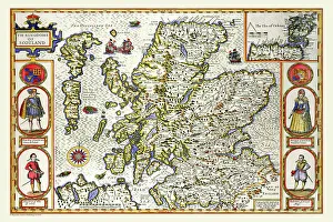
Old Map of Scotland 1611 by John SpeedA facimile of John Speeds historical map of Scotland originally published for the " Theatre of the Empire of Great Britain", an atlas to accompany " a history of Great Britain"
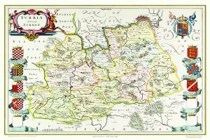
Old County Map of Surrey 1648 by Johan Blaeu from the Atlas NovusThis detailed and most attractive reproduction map of Surrey has been carefully art worked from a scan of an antique original
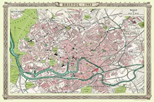
Old Map of Bristol 1903J104
Old Map of Village of Fazeley near Tamworth 1885PL025
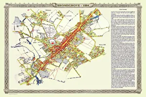
Old Map of the Town of Bromsgrove in Worcestershire 1884PL003
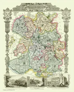
Old County Map of Shropshire 1836 by Thomas MouleThis is a fine decorative reproduction County Map of Shropshire from the First Edition series of Thomas Moule Maps, originally Published in 1836
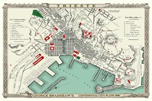
George Bradshaws Plan of Trieste, Italy 1896This is a very detailed Plan of the Port and City of Trieste showing the Port, streets, canals, principal buildings, railways and railway stations
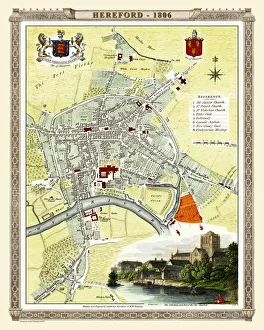
Old Map of Hereford 1806 by Cole and RoperAn attractive and detailed early 19th century reproduction town plan of Hereford 1806. First published by Cole and Roper as a finely engraved series of county maps
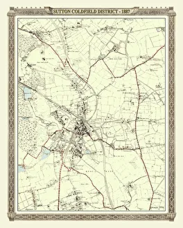
Old Map of the District of Sutton Coldfield in the West Midlands 1887PL016
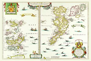
Old Map of the Isles of Shetland and Orkney 1654 from the Atlas NovusThis detailed and most attractive reproduction map of The Isles of Shetland and Orkney, has been carefully art worked from a scan of an antique original
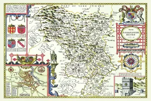
Old County Map of Derbyshire 1611 by John SpeedA facimile of John Speeds historical map of Derbyshire originally published for the " Theatre of the Empire of Great Britain", an atlas to accompany " a history of Great Britain"
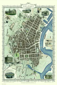
Old Map of Belfast 1851 by John TallisThe River Lagan dominates the west side of this John Tallis 1851 plan of Belfast with Queens Bridge crossing into the town of Belfast in Northern Ireland. There are six splendid illustrations
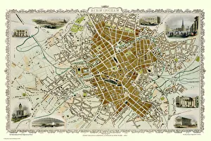
Old Map of Birmingham 1851 by John TallisThis attractive plan of mid Victorian Birmingham in the Midlands by John Tallis 1851 shows the first railways and important canal network. The work is attractively presented with eight illustrations
Old County Map of Kyle and Mid Ayrshire 1654 by johan Blaeu from the Atlas NovusThis detailed and most attractive reproduction map of Kyle and Mid Ayrshire has been carefully art worked from a scan of an antique original
Old County Map of Lancashire 1611 by John SpeedA facimile of John Speeds historical map of Lancashire published for the " Theatre of the Empire of Great Britain", an atlas to accompany " a history of Great Britain"
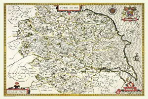
Old County Map of Yorkshire 1611 by John SpeedA facimile of John Speeds historical map of Yorkshire originally published for the " Theatre of the Empire of Great Britain", an atlas to accompany " a history of Great Britain"
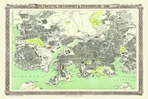
Old Map of Plymouth, Devonport and Stonehouse 1898 from the Royal Atlas by BartholomewA fine very detailed plan of the Port City of Plymouth with Devonport and Stonehouse, remastered from an original contained within " The Royal Atlas of England and Wales" ; edited by J.G
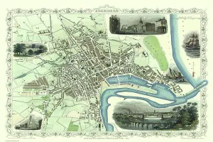
Old Map of Aberdeen 1851 by John TallisAberdeen in Scotland nestled on the River Dee with its famous Victorian Park and Harbour, John TallisAEs 1851 town plan perfectly captures this historic Scottish town during mid Victorian times