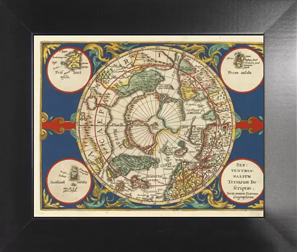
Framed Print > Maps of the Artic and Antarctic > The Arctic
Framed Print : Old Map of The North Pole "Septentrionalium Terrarum descriptio"originally Published by Johannes Cloppenburg 1632


![]()
Framed Photos from MapSeeker
Old Map of The North Pole "Septentrionalium Terrarum descriptio"originally Published by Johannes Cloppenburg 1632
A striking reproduction from Cloppenburgs reduced size edition of Mercators map of the North Polar regions, the first separate map of the North Polar Regions. Gerard Mercator was the first cartographer to create a polar projection of the earth. This map, the first separate map devoted to the Arctic regions, is drawn from an inset on Mercators world map of 1569. The map is extended to 60 degrees, to incorporate the recent explorations in search of the North West and North East Passages by Frobisher and Davis
Media ID 20347045
12"x10" Modern Frame
10x8 Print in an MDF Wooden Frame with 180 gsm Satin Finish Paper. Glazed using shatter proof thin plexi glass. Frame thickness is 1 inch and depth 0.75 inch. Fluted cardboard backing held with clips. Supplied ready to hang with sawtooth hanger and rubber bumpers. Spot clean with a damp cloth. Packaged foam wrapped in a card.
Contemporary Framed and Mounted Prints - Professionally Made and Ready to Hang
Estimated Image Size (if not cropped) is 25.4cm x 25.4cm (10" x 10")
Estimated Product Size is 30.5cm x 25.4cm (12" x 10")
These are individually made so all sizes are approximate
Artwork printed orientated as per the preview above, with landscape (horizontal) or portrait (vertical) orientation to match the source image.
MADE IN THE USA
Safe Shipping with 30 Day Money Back Guarantee
FREE PERSONALISATION*
We are proud to offer a range of customisation features including Personalised Captions, Color Filters and Picture Zoom Tools
SECURE PAYMENTS
We happily accept a wide range of payment options so you can pay for the things you need in the way that is most convenient for you
* Options may vary by product and licensing agreement. Zoomed Pictures can be adjusted in the Cart.