mail_outline sales@mediastorehouse.com
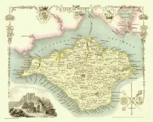
Old Map of The Isle of Wight 1836 by Thomas MouleThis is a fine decorative reproduction Map of The Isle of Wight from the First Edition series of Thomas Moule Maps, originally Published in 1836
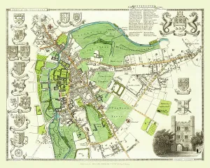
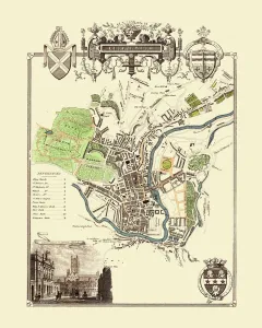
Old Map of the City of Cambridge 1836 by Thomas MouleThis is a fine decorative reproduction Map of The City of Cambridge from the First Edition series of Thomas Moule Maps, originally Published in 1836
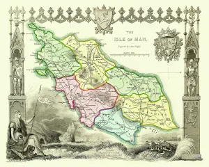
Old Map of The Isle of Man 1836 by Thomas MouleThis is a fine decorative reproduction Map of The Isle of Man from the First Edition series of Thomas Moule Maps, originally Published in 1836
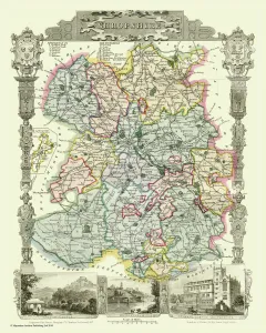
Old County Map of Shropshire 1836 by Thomas MouleThis is a fine decorative reproduction County Map of Shropshire from the First Edition series of Thomas Moule Maps, originally Published in 1836
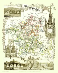
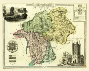
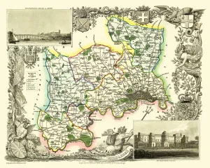
Old County Map of Worcestershire 1836 by Thomas MouleThis is a fine decorative reproduction County Map of Worcestershire from the First Edition series of Thomas Moule Maps, originally Published in 1836
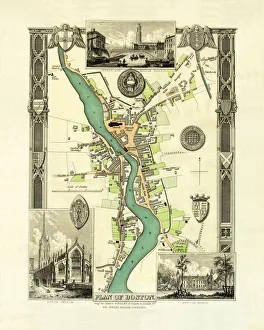
Old Map of Boston England 1836 by Thomas MouleThis is a fine decorative reproduction Map of The Town of Boston from the First Edition series of Thomas Moule Maps, originally Published in 1836
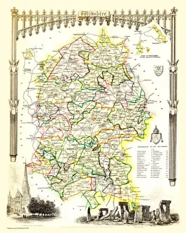
Old County Map of Wiltshire 1836 by Thomas MouleThis is a fine decorative reproduction County Map of Wiltshire from the First Edition series of Thomas Moule Maps, originally Published in 1836
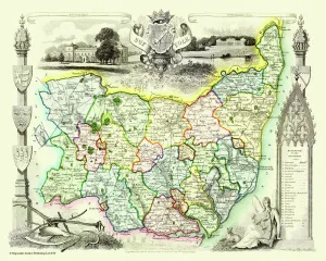
Old County Map of Suffolk 1836 by Thomas MouleThis is a fine decorative reproduction County Map of Suffolk from the First Edition series of Thomas Moule Maps, originally Published in 1836
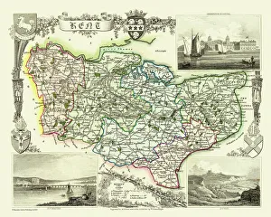
Old County Map of Kent 1836 by Thomas MouleThis is a fine decorative reproduction County Map of Kent from the First Edition series of Thomas Moule Maps, originally Published in 1836
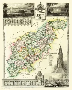
Old County Map of Northamptonshire 1836 by Thomas MouleThis is a fine decorative reproduction County Map of Northamptonshire from the First Edition series of Thomas Moule Maps, originally Published in 1836
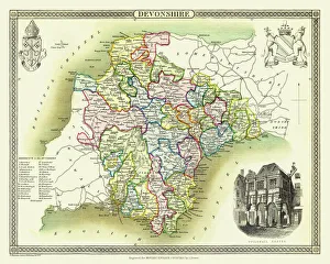
Old County Map of Devonshire 1836 by Thomas MouleThis is a fine decorative reproduction County Map of Devonshire from the First Edition series of Thomas Moule Maps, originally Published in 1836
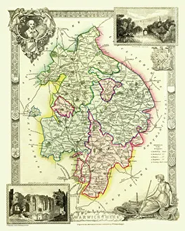
Old County Map of Warwickshire 1836 by Thomas MouleThis is a fine decorative reproduction County Map of Warwickshire from the First Edition series of Thomas Moule Maps, originally Published in 1836
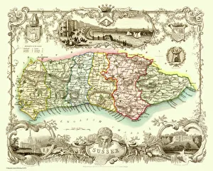
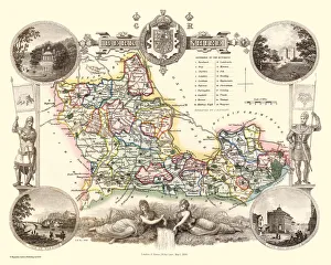
Old County Map of Sussex 1836 by Thomas MouleThis is a fine decorative reproduction County Map of Sussex from the First Edition series of Thomas Moule Maps, originally Published in 1836
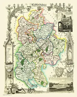
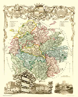
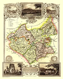
Old County Map of Bedfordshire 1836 by Thomas MouleThis is a fine decorative reproduction County Map of Bedfordshire from the First Edition series of Thomas Moule Maps, originally Published in 1836
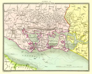
Old Map of the Environs of Portsmouth 1836 by Thomas MouleThis is a fine decorative reproduction Map of The Environs of Portsmouth from the First Edition series of Thomas Moule Maps, originally Published in 1836
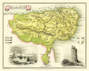
Old Map of The Isle of Thanet 1836 by Thomas MouleThis is a fine decorative reproduction Map of The Isle of Thanet from the First Edition series of Thomas Moule Maps, originally Published in 1836
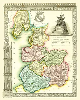
Old County Map of Lancashire 1836 by Thomas MouleThis is a fine decorative reproduction County Map of Lancashire from the First Edition series of Thomas Moule Maps, originally Published in 1836
Old Map of the City of Bath 1836 by Thomas MouleThis is a fine decorative reproduction Map of The City of Bath from the First Edition series of Thomas Moule Maps, originally Published in 1836
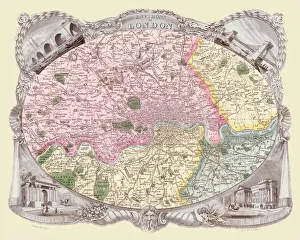
Old Map of the Environs of London 1836 by Thomas MouleThis is a fine decorative reproduction Map of The Environs of London from the First Edition series of Thomas Moule Maps, originally Published in 1836
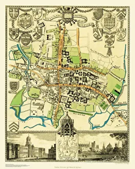
Old Map of the City Oxford 1836 by Thomas MouleThis is a fine decorative reproduction Map of The City of Oxford from the First Edition series of Thomas Moule Maps, originally Published in 1836
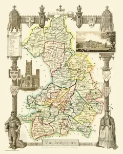
Old County Map of Cambridgeshire 1836 by Thomas MouleThis is a fine decorative reproduction County Map of Cambridgeshire from the First Edition series of Thomas Moule Maps, originally Published in 1836
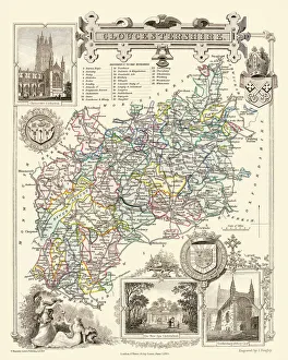
Old County Map of Gloucestershire 1836 by Thomas MouleThis is a fine decorative reproduction County Map of Gloucestershire from the First Edition series of Thomas Moule Maps, originally Published in 1836
Old County Map of Berkshire 1836 by Thomas MouleThis is a fine decorative reproduction County Map of Berkshire from the First Edition series of Thomas Moule Maps, originally Published in 1836
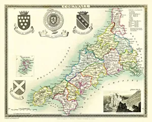
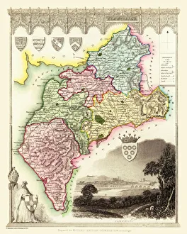
Old County Map of Cornwall 1836 by Thomas MouleThis is a fine decorative reproduction County Map of Cornwall from the First Edition series of Thomas Moule Maps, originally Published in 1836
Old Map of the Environs of Bath and Bristol 1836 by Thomas MouleThis is a fine decorative reproduction Map of The Environs of Bath and Bristol from the First Edition series of Thomas Moule Maps, originally Published in 1836
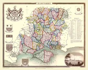
Old County Map of Hampshire 1836 by Thomas MouleThis is a fine decorative reproduction County Map of Hampshire from the First Edition series of Thomas Moule Maps, originally Published in 1836
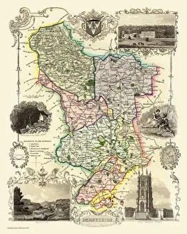
Old County Map of Derbyshire 1836 by Thomas MouleThis is a fine decorative reproduction County Map of Derbyshire from the First Edition series of Thomas Moule Maps, originally Published in 1836
Old County Map of Cumberland 1836 by Thomas MouleThis is a fine decorative reproduction County Map of Cumberland from the First Edition series of Thomas Moule Maps, originally Published in 1836
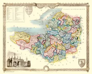
Old County Map of Somersetshire 1836 by Thomas MouleThis is a fine decorative reproduction County Map of Somersetshire from the First Edition series of Thomas Moule Maps, originally Published in 1836
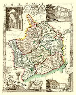
Old County Map of Monmouthshire 1836 by Thomas MouleThis is a fine decorative reproduction County Map of Monmouthshire from the First Edition series of Thomas Moule Maps, originally Published in 1836
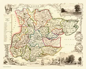
Old County Map of Essex 1836 by Thomas MouleThis is a fine decorative reproduction County Map of Essex from the First Edition series of Thomas Moule Maps, originally Published in 1836
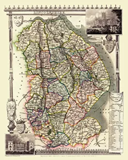
Old County Map of Lincolnshire 1836 by Thomas MouleThis is a fine decorative reproduction County Map of Lincolnshire from the First Edition series of Thomas Moule Maps, originally Published in 1836
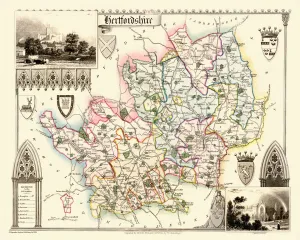
Old County Map of Hertfordshire 1836 by Thomas MouleThis is a fine decorative reproduction County Map of Hertfordshire from the First Edition series of Thomas Moule Maps, originally Published in 1836
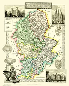
Old County Map of Staffordshire 1836 by Thomas MouleThis is a fine decorative reproduction County Map of Staffordshire from the First Edition series of Thomas Moule Maps, originally Published in 1836
Old County Map of Herefordshire 1836 by Thomas MouleThis is a fine decorative reproduction County Map of Herefordshire from the First Edition series of Thomas Moule Maps, originally Published in 1836
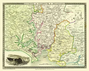
Old Map of the Environs of Plymouth and Devonport 1836 by Thomas MouleThis is a fine decorative reproduction Map of The Environs of Plymouth and Devonport from the First Edition series of Thomas Moule Maps, originally Published in 1836
Old County Map of Westmoreland 1836 by Thomas MouleThis is a fine decorative reproduction County Map of Westmoreland from the First Edition series of Thomas Moule Maps, originally Published in 1836
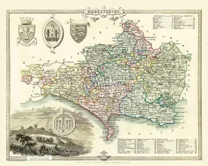
Old County Map of Dorsetshire 1836 by Thomas MouleThis is a fine decorative reproduction County Map of Dorsetshire from the First Edition series of Thomas Moule Maps, originally Published in 1836
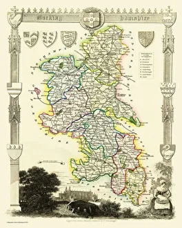
Old County Map of Buckinghamshire 1836 by Thomas MouleThis is a fine decorative reproduction County Map of Buckinghamshire from the First Edition series of Thomas Moule Maps, originally Published in 1836
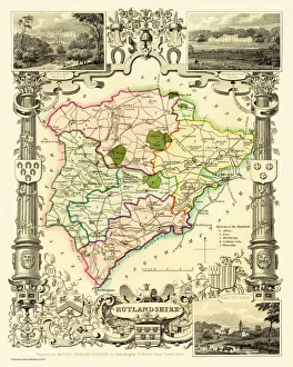
Old County Map of Rutlandshire 1836 by Thomas MouleThis is a fine decorative reproduction County Map of Rutlandshire from the First Edition series of Thomas Moule Maps, originally Published in 1836
Old County Map of Middlesex 1836 by Thomas MouleThis is a fine decorative reproduction County Map of Middlesex from the First Edition series of Thomas Moule Maps, originally Published in 1836
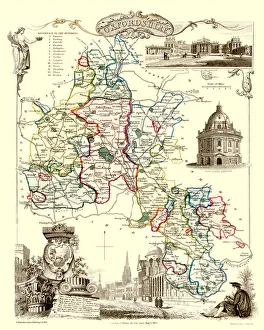
Old County Map of Oxfordshire 1836 by Thomas MouleThis is a fine decorative reproduction County Map of Oxfordshire from the First Edition series of Thomas Moule Maps, originally Published in 1836
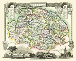
Old County Map of Norfolk 1836 by Thomas MouleThis is a fine decorative reproduction County Map of Norfolk from the First Edition series of Thomas Moule Maps, originally Published in 1836
Old County Map of Leicestershire 1836 by Thomas MouleThis is a fine decorative reproduction County Map of Leicestershire from the First Edition series of Thomas Moule Maps, originally Published in 1836
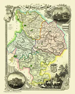
Old County Map of Huntingdonshire 1836 by Thomas MouleThis is a fine decorative reproduction County Map of Huntingdonshire from the First Edition series of Thomas Moule Maps, originally Published in 1836