Home > Maps from the British Isles > Islands around Britain PORTFOLIO
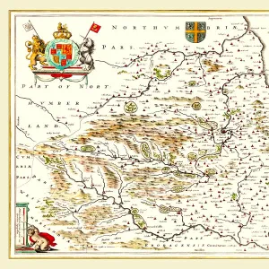
Old Map of The Isle of Man 1836 by Thomas Moule

![]()
Wall Art and Photo Gifts from MapSeeker
Old Map of The Isle of Man 1836 by Thomas Moule
This is a fine decorative reproduction Map of The Isle of Man from the First Edition series of Thomas Moule Maps, originally Published in 1836. The well-known series of County Maps which are known as Moules feature beautiful vignette views and were first published in separate sections for each county in 1830-32, they were then published in collected form in a two-volume work: The English Counties Delineated: or a Topographical Description of England: Illustrated by a Complete Series of County Maps by Thomas Moule: London: Published by George Virtue 1836
Media ID 20347905
© Mapseeker Publishing Ltd
Historic Map Moule Map Old Moule Map Thomas Moule Thomas Moule Map
MADE IN THE UK
Safe Shipping with 30 Day Money Back Guarantee
FREE PERSONALISATION*
We are proud to offer a range of customisation features including Personalised Captions, Color Filters and Picture Zoom Tools
SECURE PAYMENTS
We happily accept a wide range of payment options so you can pay for the things you need in the way that is most convenient for you
* Options may vary by product and licensing agreement. Zoomed Pictures can be adjusted in the Basket.