Home > Maps from the British Isles > Scotland and Counties PORTFOLIO
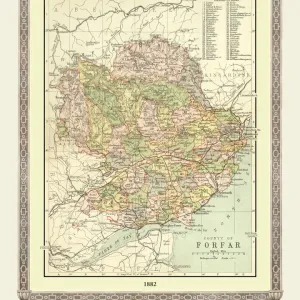
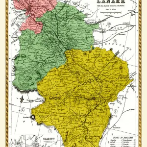
Old County Map of Forfar Scotland 1847 by A&C Black

![]()
Wall Art and Photo Gifts from MapSeeker
Old County Map of Forfar Scotland 1847 by A&C Black
A finely detailed facimile remastered in full colour from an antique original map of Forfar featured in A&C Blacks Atlas of 1847. Each Parish is numbered using an index table, colour rendition beautifully differentiating all of the Parishes. As well as principal roads, towns, villages and hamlets, these county maps of Scotland feature key battle sites marked with two crossed swords and the date of the battle
Media ID 20347459
© Mapseeker Publishing Ltd
A And C Black A And C Black Atlas A And C Black Map County Map County Map Of Scotland Historic Map Old County Map Old Scottish County Map Scottish County Map
MADE IN THE UK
Safe Shipping with 30 Day Money Back Guarantee
FREE PERSONALISATION*
We are proud to offer a range of customisation features including Personalised Captions, Color Filters and Picture Zoom Tools
SECURE PAYMENTS
We happily accept a wide range of payment options so you can pay for the things you need in the way that is most convenient for you
* Options may vary by product and licensing agreement. Zoomed Pictures can be adjusted in the Basket.