Home > Pictorial Maps and Pictorial History
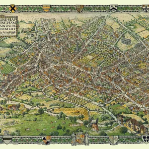
Pictorial Plan of Chester by W. Willis c1865

![]()
Wall Art and Photo Gifts from MapSeeker
Pictorial Plan of Chester by W. Willis c1865
This is a superb republishing in full colour of the pictorial map created by W.Willis in the 1860 s. Pictographs of buildings dot the map, including a most impressive view of Chester Railway Station, opposite the recently opened Queens Hotel. There is a list of Historical Events, and of Statistics (visits by royalty 1276-1642)
Media ID 20354106
© Mapseeker Publishing Ltd
MADE IN THE UK
Safe Shipping with 30 Day Money Back Guarantee
FREE PERSONALISATION*
We are proud to offer a range of customisation features including Personalised Captions, Color Filters and Picture Zoom Tools
SECURE PAYMENTS
We happily accept a wide range of payment options so you can pay for the things you need in the way that is most convenient for you
* Options may vary by product and licensing agreement. Zoomed Pictures can be adjusted in the Basket.