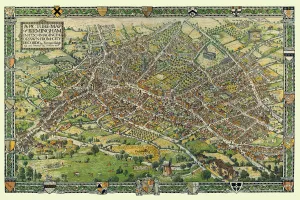
British Town And City Plans Gallery
Old Town and City Plans from England, Wales, Scotland and Ireland - 16th, 17th, 18th and 19th Centuries
Choose from 198 pictures in our British Town And City Plans collection for your Wall Art or Photo Gift. All professionally made for Quick Shipping.
Folded Maps
Books & Atlases
Maps from the British Isles
British Town And City Plans
> English & Welsh PORTFOLIO
> Scottish PORTFOLIO
Old Views and Vistas
Maps of Africa and Oceana
Maps of the Americas
Maps of Europe
Maps of Asia and Middle East
Maps Showing the World
Old Railway and Canal Map Collection
Pictorial Maps and Pictorial History
British History Related and Military
All Images

British town city plans/english welsh portfolio/old map sutton park near sutton coldfield 1885
Full Range of Prints and Gifts in Stock

British town city plans/english welsh portfolio/old map district sutton coldfield west midlands
Full Range of Prints and Gifts in Stock

British town city plans/english welsh portfolio/old street map isle dogs river thames greenwich
Full Range of Prints and Gifts in Stock

Old Map of Birmingham Surveyed in 1731 by William Westley
Attractive republication in full colour of the first printed map of Birmingham, The Plan of Birmingham, surveyed by William Westley in 1731, is dedicated to the two Members of Parliament for Warwickshire, the Honourable Edward Digby and William Peyto Esquire. It shows the town in the early years of George II's reign with a population of over fifteen thousand, with two churches, a water mill and a manor house surrounded by a moat. Parts of the built-up area have gardens and orchards, even near the centre, and the town is closely surrounded by fields. The work was carried out for inclusion in "Birmingham A History in Maps", published in 2009
© Mapseeker Publishing Ltd

Old Map of the Turnpike Road u Erdington 1833 with Stagecoaches at "The Green"
Full Range of Prints and Gifts in Stock

Old Map of the Manufacturing Districts of Staffordshire and Worcestershire 1836
Full Range of Prints and Gifts in Stock

Old Map of Liverpool 1785 by Surveyed by Charles Eyes
This most impressive reproduction map has been completely art worked in full colour from the very rare antique original, large, black and white, detailed plan of Liverpool published by Charles Eyes. The map is a truly local publication as it was also engraved in Liverpool - by Thomas Condor. It has been painstakingly reproduced and shows the green hedgerows of lands not yet built upon, and for each shows the names of the respective landowners, which makes this work a treasure trove to those researching family history, genealogists and those keen on the history of Liverpool. All docks are named, roads and streets, important buildings as well as the occasional windmill. Some of these landownerAEs names were given to some of the streets that rapidly spread out into the rural aspects of the time, for example Bold Street has recently been cut, yet the plan still shows the adjacent land owned by oMr Boldo

Old Map of Newcastle upon Tyne and Gateshead 1808 by Cole and Roper
Full Range of Prints and Gifts in Stock

Old Map of the Environs of Plymouth and Devonport 1836 by Thomas Moule
Full Range of Prints and Gifts in Stock

Old Map of the Environs of Plymouth and Devonport 1836 by Thomas Moule
This is a fine decorative reproduction Map of The Environs of Plymouth and Devonport from the First Edition series of Thomas Moule Maps, originally Published in 1836. The well-known series of County Maps which are known as Moules feature beautiful vignette views, there were also 4 "Environs" Maps included, and were first published in separate sections for each county in 1830-32, they were then published in collected form in a two-volume work: The English Counties Delineated: or a Topographical Description of England: Illustrated by a Complete Series of County Maps by Thomas Moule: London: Published by George Virtue 1836
© Mapseeker Publishing Ltd