Home > British Town And City Plans > English & Welsh PORTFOLIO
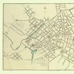
Old Map of Bradford 1851 by John Tallis

![]()
Wall Art and Photo Gifts from MapSeeker
Old Map of Bradford 1851 by John Tallis
In this John Tallis 1851 map of Bradford in west Yorkshire the railways are now well established, buildings now stretch out from the centre of Bradford along the main artery roads. There are no fewer than seven illustrations on the plan of Bradford, Yorkshire. These illustrations are of the Terminus of the Bradford and Halifax Railway, Infirmary Cemetery, St Peters Church, Roman Catholic Church, Airdale College and St Georges Hall
Media ID 20347638
Historic Map John Tallis John Tallis Map Old Town Plan Tallis Map
MADE IN THE UK
Safe Shipping with 30 Day Money Back Guarantee
FREE PERSONALISATION*
We are proud to offer a range of customisation features including Personalised Captions, Color Filters and Picture Zoom Tools
SECURE PAYMENTS
We happily accept a wide range of payment options so you can pay for the things you need in the way that is most convenient for you
* Options may vary by product and licensing agreement. Zoomed Pictures can be adjusted in the Basket.