mail_outline sales@mediastorehouse.com
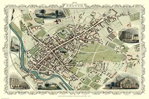
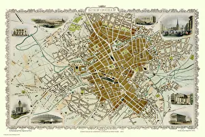
Old Map of Exeter 1851 by John TallisThe River Exe skirts the South West of this plan of Exeter in Devon by John Tallis 1851 with the Exe Bridge providing direct access through the heart of Exeter
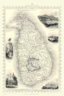
British Ceylon, or Sri Lanka 1851A fine facimile artworked from an antique original map of British Ceylon or Sri Lanka, issued as part of the 1851 edition of John Tallis and Companys " The Illustrated Atlas
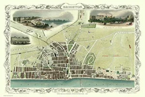
Old Map of Brighton 1851 by John TallisA most attractive Victorian plan of Brighton in Sussex by John Tallis 1851 showing its famous Chain Pier reaching out into the English Channel
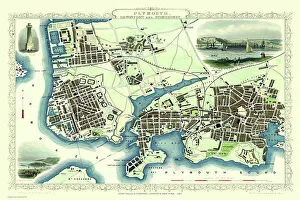
Old Map of Plymouth Devonport and Stonehouse 1851 by John TallisAn attractive Victorian plan of Plymouth in Devon by John Tallis 1851, with Morice Town, Higher Stoke, Stoke, Devonport and Stonehouse
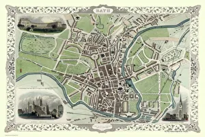
Old Map of Bath 1851 by John TallisThis is a splendid Victorian map by John Tallis 1851 of the historic Spa City of Bath in North East Somerset nestled between a bend on the River Avon
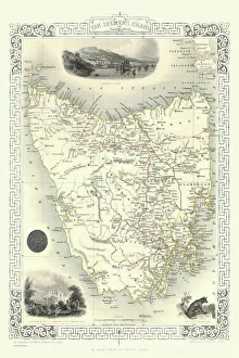
Van Diemens Island, or Tasmania 1851A fine facimile artworked from an antique original map of Van Diemens Land or Tasmania, issued as part of the 1851 edition of John Tallis and Companys " The Illustrated Atlas
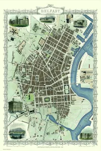
Old Map of Belfast 1851 by John TallisThe River Lagan dominates the west side of this John Tallis 1851 plan of Belfast with Queens Bridge crossing into the town of Belfast in Northern Ireland. There are six splendid illustrations
Old Map of Birmingham 1851 by John TallisThis attractive plan of mid Victorian Birmingham in the Midlands by John Tallis 1851 shows the first railways and important canal network. The work is attractively presented with eight illustrations
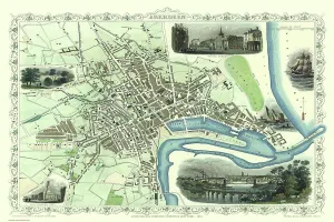
Old Map of Aberdeen 1851 by John TallisAberdeen in Scotland nestled on the River Dee with its famous Victorian Park and Harbour, John TallisAEs 1851 town plan perfectly captures this historic Scottish town during mid Victorian times
Old Map of Bradford 1851 by John TallisIn this John Tallis 1851 map of Bradford in west Yorkshire the railways are now well established, buildings now stretch out from the centre of Bradford along the main artery roads
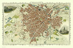
Old Map of Sheffield 1851 by John TallisA fine 1851 map by John Tallis of Victorian, industrial Sheffield in South Yorkshire that shows the steady growth of industry and housing to the left of the plan
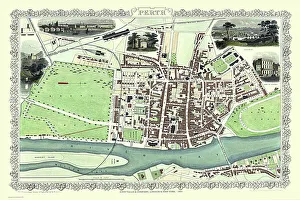
Old Map of Perth Scotland 1851 by John TallisThis 1851 John Tallis Victorian map of Perth in Scotland shows town sandwiched between the South Inch and North Inch. The plan shows only one bridge across the River Tay into Perth
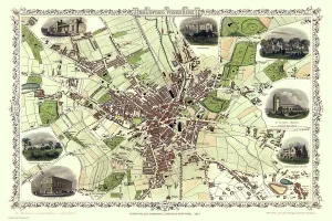
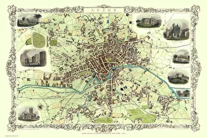
Old Map of Leeds 1851 by John TallisThis map of Leeds in West Yorkshire by John Tallis 1851 features the districts of Woodhouse Carr, Great Woodhouse, Little London, New Town, Little Woodhouse, New Wortley, Holbeck, and Hunslet
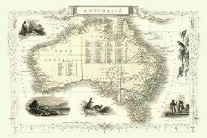
Australia 1851A fine facimile artworked from an antique original map of the Continent of Australia, issued as part of the 1851 edition of John Tallis and Companys " The Illustrated Atlas
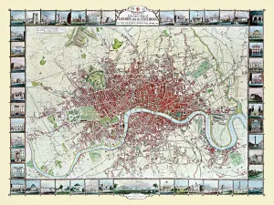
Old Map of London 1851 by John TallisCommemorating the Great Exhibition of Industry of All Nations 1851, this magnificent plan of London, re-created and art worked directly from the antique original
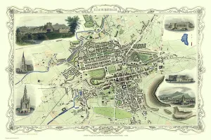
Old Map of Edinburgh Scotland 1851 by John TallisThis Victorian map of Edinburgh in Scotland by John Tallis is dominated with a view to the top right across Edinburgh from the north- west towards Edinburgh Castle
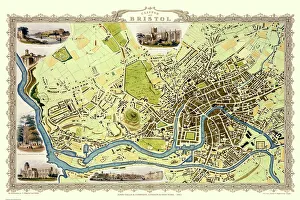
Old Map of Bristol 1851 by John TallisThis 1851 John Tallis map of Bristol shows the new course of the River Avon and the Floating Harbour. At Clifton Down the famous suspension bridge is yet to be constructed
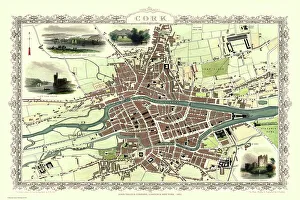
Old Map of Cork Ireland 1851 by John TallisIn this Victorian map of Cork in southern Ireland by John Tallis the North and South channels of the River Lee flow through the centre of the plan with the extensive Barracks dominating
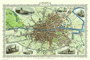
Old Map of Dublin Ireland 1851 by John TallisThis most attractive 19th Century map of Dublin in Southern Ireland by John Tallis 1851 shows all of Dublins districts, the Grand Canal networks and the arrival of the railways
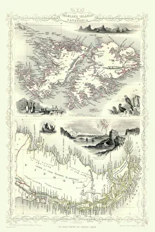
Old Map of Falkland Islands and Patagonia 1851 by John TallisA fine facimile artworked from an antique original map of the Falkland Islands and Patagonia, issued as part of the 1851 edition of John Tallis and Companys " The Illustrated Atlas
Old Map of Newcastle upon Tyne 1851 by John TallisNewcastle 1851, Gateshead is to the bottom of the John Tallis 1851 plan of Newcastle in Tyne and Wear with the famous High Level Railway crossing the River Tyne into Newcastle Central station
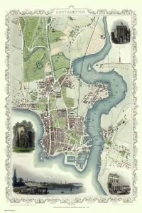
Old Map of Southampton 1851 by John TallisThe River Itchen dominates the 1851 John Tallis plan of Southampton in Hampshire with The Parks covering a great expanse to the top left
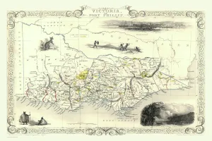
Victoria, or Port Phillip 1851A fine facimile artworked from an antique original map of Victoria, or Port Phillip, Australia, issued as part of the 1851 edition of John Tallis and Companys " The Illustrated Atlas
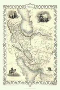
Persia, or Iran 1851A fine facimile artworked from an antique original map of Persia, or later (1935) Iran issued as part of the 1851 edition of John Tallis and Companys " The Illustrated Atlas
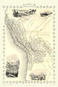
Old Map of Peru and Bolivia 1851 by John TallisA fine facimile artworked from an antique original map of Peru and Bolivia, issued as part of the 1851 edition of John Tallis and Companys " The Illustrated Atlas
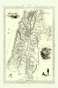
Modern Palestine 1851A fine facimile artworked from an antique original map of Modern Palestine, issued as part of the 1851 edition of John Tallis and Companys " The Illustrated Atlas
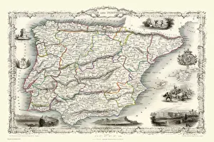
Spain & Portugal 1851A fine facimile artworked from an antique original map of Spain and Portugal, issued as part of the 1851 edition of John Tallis and Companys " The Illustrated Atlas
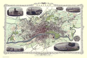
Old Map of Glasgow Scotland 1851 by John TallisThe River Clyde skirts its way through the heart of this famous Scottish City in this wonderful plan by Tallis originally published in 1851. There are six illustrations on the plan
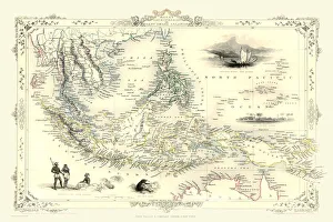
Malay Archipelago, or East India Islands 1851A fine facimile artworked from an antique original map of the Malay Archipelago, or East India Islands, issued as part of the 1851 edition of John Tallis and Companys " The Illustrated Atlas
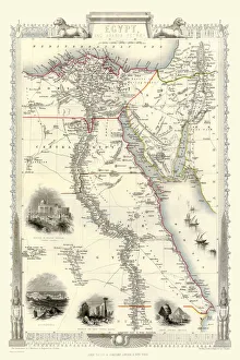
Old Map of Egypt and Arabia Petraea 1851 by John TallisA fine facimile artworked from an antique original map of Egypt and Arabia Petraea, issued as part of the 1851 edition of John Tallis and Companys " The Illustrated Atlas
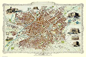
Old Map of Manchester 1851 by John TallisThis John Tallis Victorian map, 1851, of Manchester in Lancashire covers the districts of Salford, Manchester, Ardwick, Chorlton and Hulme
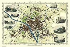
Old Map of York 1851 by John TallisThe River Ouse flows through the famous City of York, already its buildings are spreading outside its ancient walls. The 1851 John Tallis plan is illustrated with views of The Minster, Walmgate Bar
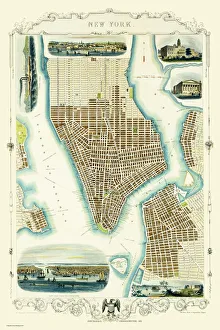
Old Map of New York United States of America 1851 by John TallisThis is a most attractive yet detailed plan 1851 by John Tallis of New York and districts of Jersey, Panovia, Hoboken, Brooklyn and Williamsburgh in the U.S.A
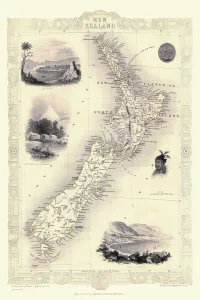
New Zealand 1851A fine facimile artworked from an antique original map of New Zealand, issued as part of the 1851 edition of John Tallis and Companys " The Illustrated Atlas and Modern History of the World"
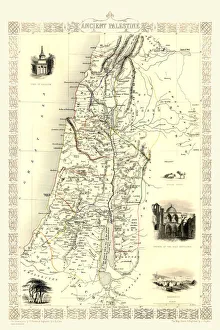
Ancient Palestine 1851A fine facimile artworked from an antique original map of Ancient Palestine, issued as part of the 1851 edition of John Tallis and Companys " The Illustrated Atlas
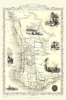
Western Australia and the Swan River 1851A fine facimile artworked from an antique original map of Western Australia and the Swan River, issued as part of the 1851 edition of John Tallis and Companys " The Illustrated Atlas
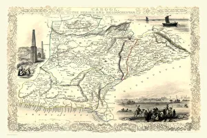
Cabool, The Punjab and Beloochistan 1851A fine facimile artworked from an antique original map of Cabool, The Punjab and Beloochistan, issued as part of the 1851 edition of John Tallis and Companys " The Illustrated Atlas
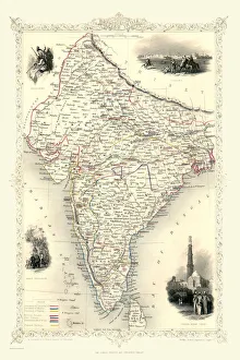
British India 1851A fine facimile artworked from an antique original map of British India, issued as part of the 1851 edition of John Tallis and Companys " The Illustrated Atlas
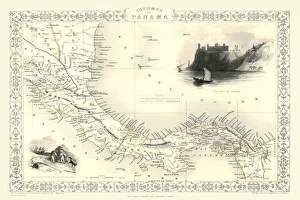
Old Map of Isthmus of Panama 1851 by John TallisA fine facimile artworked from an antique original map of the Isthmus of Panama, issued as part of the 1851 edition of John Tallis and Companys " The Illustrated Atlas
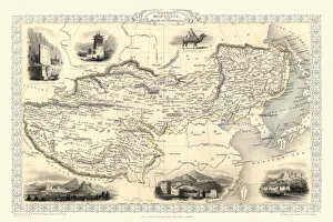
Tibet, Mongolia and Manchuria 1851A fine facimile artworked from an antique original map of Tibet, Mongolia and Manchuria, issued as part of the 1851 edition of John Tallis and Companys " The Illustrated Atlas
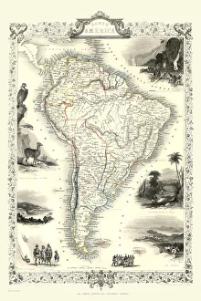
Old Map of South America 1851 by John TallisA fine facimile artworked from an antique original map of South America, issued as part of the 1851 edition of John Tallis and Companys " The Illustrated Atlas
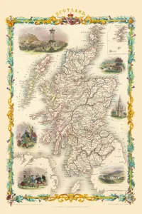
Scotland 1851A fine facimile artworked from an antique original map of Scotland, issued as part of the 1851 edition of John Tallis and Companys " The Illustrated Atlas and Modern History of the World"
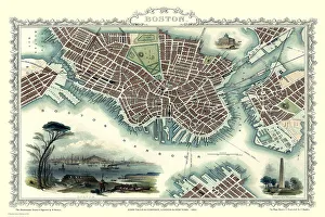
Old Map of Boston United States of America 1851 by John TallisThis a most attractive plan of Boston by John Tallis 1851 that includes South Boston Bay, part of South Boston with Charleston Town to the right of the plan
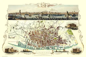
Old Map of Liverpool 1851 by John TallisRunning along the entire length of the plan of Liverpool in Lancashire by John Tallis 1851 is a most attractive view across the River Mersey from Birkenhead to the Victorian Liverpool skyline
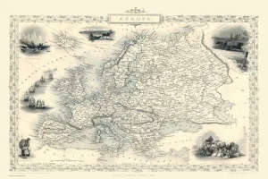
Europe 1851A fine facimile artworked from an antique original map of Europe, issued as part of the 1851 edition of John Tallis and Companys " The Illustrated Atlas and Modern History of the World"
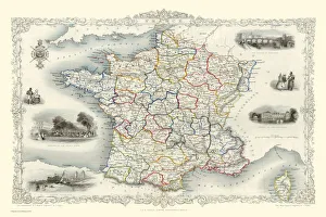
France 1851A fine facimile artworked from an antique original map of France, issued as part of the 1851 edition of John Tallis and Companys " The Illustrated Atlas and Modern History of the World"
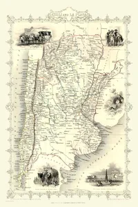
Old Map of Chile and La Plata 1851 by John TallisA fine facimile artworked from an antique original map of Chile and La Plata, issued as part of the 1851 edition of John Tallis and Companys " The Illustrated Atlas
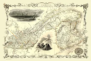
Old Map of East Canada and New Brunswick 1851 by John TallisA fine facimile artworked from an antique original map of East Canada and New Brunswick, issued as part of the 1851 edition of John Tallis and Companys " The Illustrated Atlas