Home > Maps from the British Isles > British Coastal Surveys PORTFOLIO
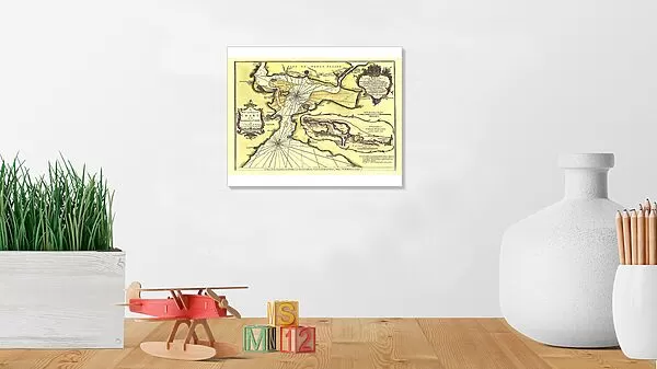
Photographic Print : Early Coastal Survey Map of Chart of the Harbour of Cork 1759

![]()
Photo Prints from MapSeeker
Early Coastal Survey Map of Chart of the Harbour of Cork 1759
This is a reproduction in colour of the early chart of Cork Harbour originally surveyed by John Lindsay, c.1759), and titled A New and Correct Chart of the Harbour of Corke by the Revd. J. Lindsay, Late of His Majestys Ship Fougueux. Sold by W. & I. Mount, T. & T. Page on Tower Hill, London. 1759, large dedication cartouche with name of Lords Commissioners, inset map of Cork harbour featuring detail of Little Island, Barrys Point, Black Rock, Glanmier, and approaches to the city - A Continuation of Corke Harbour from a smaller Scale, below the chart is a coastal profile - A View of the Land from the Old Head of Kinsale to Hawks Rock, the Old Head W bs 7 Miles
Media ID 20347483
10"x8" (25x20cm) Photo Print
Printed on archival quality paper for unrivalled stable artwork permanence and brilliant colour reproduction with accurate colour rendition and smooth tones. Printed on professional 234gsm Fujifilm Crystal Archive DP II paper. 10x8 for landscape images, 8x10 for portrait images.
Our Photo Prints are in a large range of sizes and are printed on Archival Quality Paper for excellent colour reproduction and longevity. They are ideal for framing (our Framed Prints use these) at a reasonable cost. Alternatives include cheaper Poster Prints and higher quality Fine Art Paper, the choice of which is largely dependant on your budget.
Estimated Image Size (if not cropped) is 25.4cm x 16.9cm (10" x 6.7")
Estimated Product Size is 25.4cm x 20.3cm (10" x 8")
These are individually made so all sizes are approximate
Artwork printed orientated as per the preview above, with landscape (horizontal) orientation to match the source image.
MADE IN THE UK
Safe Shipping with 30 Day Money Back Guarantee
FREE PERSONALISATION*
We are proud to offer a range of customisation features including Personalised Captions, Color Filters and Picture Zoom Tools
SECURE PAYMENTS
We happily accept a wide range of payment options so you can pay for the things you need in the way that is most convenient for you
* Options may vary by product and licensing agreement. Zoomed Pictures can be adjusted in the Cart.