Framed Print > British Town And City Plans > Scottish PORTFOLIO
Framed Print : Old Map of Edinburgh and Leith 1864 by G. W. Swanson


![]()
Framed Photos from MapSeeker
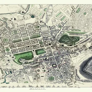
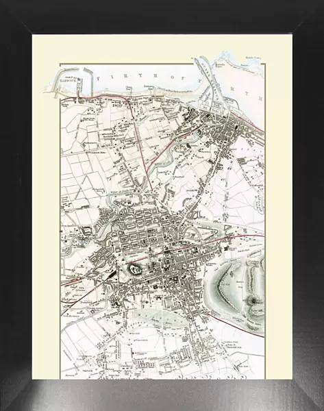
Old Map of Edinburgh and Leith 1864 by G. W. Swanson
Splendid reproduction map of Edinburgh originally drawn and engraved by G.H.Swanson. The plan of Edinburgh and Leith shows exceptional detail. Buildings are finely drawn with important buildings such as the castle displayed in block ink. The early railways, along with all roads are named. At the top of the plan there is the Firth of Forth along with its piers, harbour and docks. At the bottom of the map even the smallest of residences of Morningside are detailed and in many cases named
Media ID 20347174
Edinburgh Historic Map Old Town Plan
18"x14" Modern Frame
16x12 Print in an MDF Wooden Frame with 180 gsm Satin Finish Paper. Glazed using shatter proof thin plexiglass. Frame thickness is 1 inch and depth 0.75 inch. Fluted cardboard backing held with clips. Supplied ready to hang with sawtooth hanger and rubber bumpers. Spot clean with a damp cloth. Packaged foam wrapped in a card.
Contemporary Framed and Mounted Prints - Professionally Made and Ready to Hang
Estimated Image Size (if not cropped) is 35.6cm x 40.6cm (14" x 16")
Estimated Product Size is 35.6cm x 45.7cm (14" x 18")
These are individually made so all sizes are approximate
Artwork printed orientated as per the preview above, with portrait (vertical) orientation to match the source image.
MADE IN THE USA
Safe Shipping with 30 Day Money Back Guarantee
FREE PERSONALISATION*
We are proud to offer a range of customisation features including Personalised Captions, Color Filters and Picture Zoom Tools
SECURE PAYMENTS
We happily accept a wide range of payment options so you can pay for the things you need in the way that is most convenient for you
* Options may vary by product and licensing agreement. Zoomed Pictures can be adjusted in the Cart.