Home > British Town And City Plans > Scottish PORTFOLIO
Old Map of Glasgow Scotland 1851 by John Tallis

![]()
Wall Art and Photo Gifts from MapSeeker
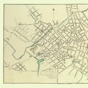
Old Map of Glasgow Scotland 1851 by John Tallis
The River Clyde skirts its way through the heart of this famous Scottish City in this wonderful plan by Tallis originally published in 1851. There are six illustrations on the plan. These illustrations are a set of picturesque views, The Exchange, the Cathedral, Royal Bank of Scotland, The University, the New Bridge over the Clyde and a lovely view of Glasgow from The Green
Media ID 20347884
Historic Map John Tallis John Tallis Map Old Town Plan Tallis Map
MADE IN THE UK
Safe Shipping with 30 Day Money Back Guarantee
FREE PERSONALISATION*
We are proud to offer a range of customisation features including Personalised Captions, Color Filters and Picture Zoom Tools
SECURE PAYMENTS
We happily accept a wide range of payment options so you can pay for the things you need in the way that is most convenient for you
* Options may vary by product and licensing agreement. Zoomed Pictures can be adjusted in the Basket.