Home > British Town And City Plans > English & Welsh PORTFOLIO
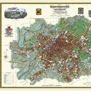
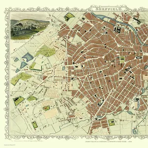
Old Map of Manchester 1851 by John Tallis

![]()
Wall Art and Photo Gifts from MapSeeker
Old Map of Manchester 1851 by John Tallis
This John Tallis Victorian map, 1851, of Manchester in Lancashire covers the districts of Salford, Manchester, Ardwick, Chorlton and Hulme. Railways are now established, however the plan beautifully illustrates the complex shipping canals snaking their way through Manchester and Salford. The illustrations finishing the plan are of the Royal Infirmary, Branch of the Bank of England, Royal Institution, Town Hall, Post Office, Free Library and Collegiate Church
Media ID 20347640
Historic Map John Tallis John Tallis Map Old Town Plan Tallis Map
MADE IN THE UK
Safe Shipping with 30 Day Money Back Guarantee
FREE PERSONALISATION*
We are proud to offer a range of customisation features including Personalised Captions, Color Filters and Picture Zoom Tools
SECURE PAYMENTS
We happily accept a wide range of payment options so you can pay for the things you need in the way that is most convenient for you
* Options may vary by product and licensing agreement. Zoomed Pictures can be adjusted in the Basket.