Framed Print > British Town And City Plans > English & Welsh PORTFOLIO
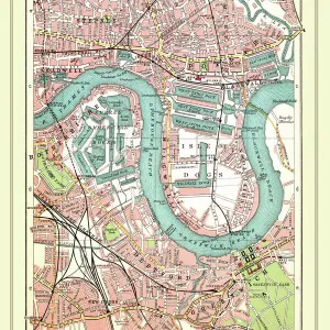
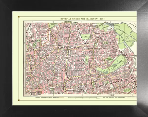
Framed Print : Old Street Map of Bethnal Green and Hackney 1908


![]()
Framed Photos from MapSeeker
Old Street Map of Bethnal Green and Hackney 1908
Detailed colour Street Plan of London from 1908 covering the area around Bethnal Green and Hackney. The image has been remastered from Bartholomews Handy Atlas of London and Suburbs 1908
Media ID 20347777
© Mapseeker Publishing Ltd, Collins Bartholomew Ltd
London Map London Street Plan Map Of Central London Map Of London Old London Street Map Old Map Of London Central Street Map Of London Street Plan
18"x14" Modern Frame
16x12 Print in an MDF Wooden Frame with 180 gsm Satin Finish Paper. Glazed using shatter proof thin plexiglass. Frame thickness is 1 inch and depth 0.75 inch. Fluted cardboard backing held with clips. Supplied ready to hang with sawtooth hanger and rubber bumpers. Spot clean with a damp cloth. Packaged foam wrapped in a card.
Contemporary Framed and Mounted Prints - Professionally Made and Ready to Hang
Estimated Image Size (if not cropped) is 40.6cm x 35.6cm (16" x 14")
Estimated Product Size is 45.7cm x 35.6cm (18" x 14")
These are individually made so all sizes are approximate
Artwork printed orientated as per the preview above, with landscape (horizontal) orientation to match the source image.
MADE IN THE USA
Safe Shipping with 30 Day Money Back Guarantee
FREE PERSONALISATION*
We are proud to offer a range of customisation features including Personalised Captions, Color Filters and Picture Zoom Tools
SECURE PAYMENTS
We happily accept a wide range of payment options so you can pay for the things you need in the way that is most convenient for you
* Options may vary by product and licensing agreement. Zoomed Pictures can be adjusted in the Cart.