Home > Maps from the British Isles > England and Counties PORTFOLIO
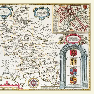
Old County Map of Berkshire 1611 by John Speed

![]()
Wall Art and Photo Gifts from MapSeeker
Old County Map of Berkshire 1611 by John Speed
A facimile of John Speeds historical map of Berkshire originally published for the " Theatre of the Empire of Great Britain", an atlas to accompany " a history of Great Britain".
The top of Speeds map of Berkshire is illustrated with a magnificent drawing of Windsor Castle. Speed notes that here was the headquarters of the Order of the Garter and there is a picture of James I wearing the robes and insignia of the order. There is an illustration of a battle fought at Radcott Bridge in 1387
Media ID 20347715
© Mapseeker Publishing Ltd
County Map County Map Of England English County Map Historic Map John Speed Map Old County Map Old English County Map Speed Map Speede Map
MADE IN THE USA
Safe Shipping with 30 Day Money Back Guarantee
FREE PERSONALISATION*
We are proud to offer a range of customisation features including Personalised Captions, Color Filters and Picture Zoom Tools
SECURE PAYMENTS
We happily accept a wide range of payment options so you can pay for the things you need in the way that is most convenient for you
* Options may vary by product and licensing agreement. Zoomed Pictures can be adjusted in the Cart.