mail_outline sales@mediastorehouse.com
389 items
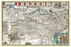
Old County Map of Northamptonshire 1836 by Thomas MouleThis is a fine decorative reproduction County Map of Northamptonshire from the First Edition series of Thomas Moule Maps, originally Published in 1836
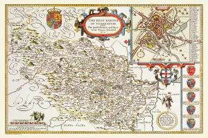
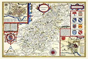
Old County Map of Yorkshire West Riding 1611 by John SpeedA facimile of John Speeds historical map of Yorkshire West Riding originally published for the " Theatre of the Empire of Great Britain"
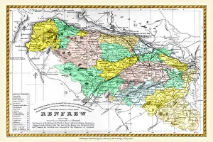
Old County Map of Renfrew Scotland 1847 by A&C BlackA finely detailed facimile remastered in full colour from an antique original map of Renfrewshire featured in A&C Blacks Atlas of 1847
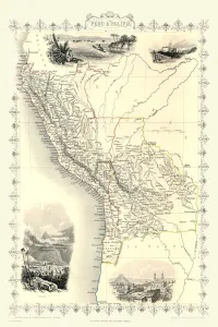
Old Map of Peru and Bolivia 1851 by John TallisA fine facimile artworked from an antique original map of Peru and Bolivia, issued as part of the 1851 edition of John Tallis and Companys " The Illustrated Atlas
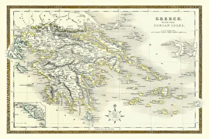
Old Map of Greece with the Ionian Isles 1852 by Henry George CollinsThis is a finely detailed map of Greece remastered from a rare Atlas of the World published in 1852 by Henry George Collins
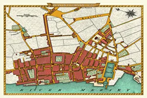
Old Map of Liverpool 1725J119
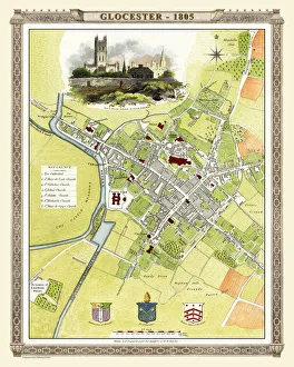
Old Map of Gloucester 1805 by Cole and RoperAn attractive and detailed early 19th century reproduction town plan of Gloucester 1805. First published by Cole and Roper as a finely engraved series of county maps
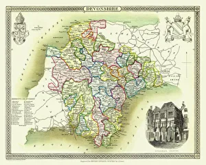
Old County Map of Devonshire 1836 by Thomas MouleThis is a fine decorative reproduction County Map of Devonshire from the First Edition series of Thomas Moule Maps, originally Published in 1836
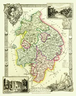
Old County Map of Warwickshire 1836 by Thomas MouleThis is a fine decorative reproduction County Map of Warwickshire from the First Edition series of Thomas Moule Maps, originally Published in 1836
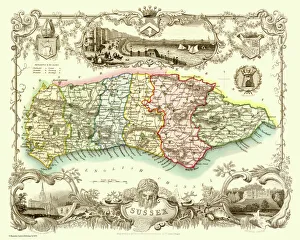
Old County Map of Sussex 1836 by Thomas MouleThis is a fine decorative reproduction County Map of Sussex from the First Edition series of Thomas Moule Maps, originally Published in 1836
Old County Map of Gloucestershire 1611 by John SpeedA facimile of John Speeds historical map of Gloucestershire originally published for the " Theatre of the Empire of Great Britain"
Old County Map of Cambridgeshire 1611 by John SpeedA facimile of John Speeds historical map of Cambridgeshire originally published for the " Theatre of the Empire of Great Britain"
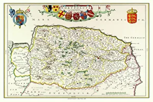
Old County Map of Norfolk 1648 by Johan Blaeu from the Atlas NovusThis detailed and most attractive reproduction map of Norfolk has been carefully art worked from a scan of an antique original
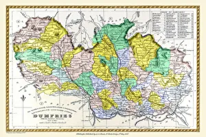
Old County Map of Dumfries Scotland 1847 by A&C BlackA finely detailed facimile remastered in full colour from an antique original map of Dumfries featured in A&C Blacks Atlas of 1847
Old County Map of Leicestershire 1611 by John SpeedA facimile of John Speeds historical map of Leicestershire originally published for the " Theatre of the Empire of Great Britain"
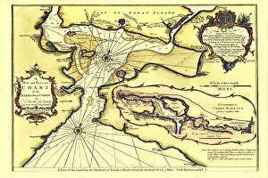
Early Coastal Survey Map of Chart of the Harbour of Cork 1759This is a reproduction in colour of the early chart of Cork Harbour originally surveyed by John Lindsay, c.1759), and titled A New and Correct Chart of the Harbour of Corke by the Revd. J
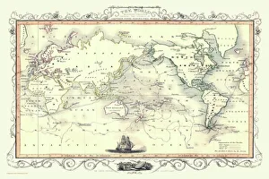
Old Map of the World on Mercators Projection 1851 Showing the Voyages of Captain Cook by John TallisA fine facimile artworked from an antique original map of The World on Mercators Projection Showing the Voyages of Capatain Cook
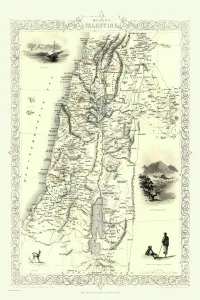
Modern Palestine 1851A fine facimile artworked from an antique original map of Modern Palestine, issued as part of the 1851 edition of John Tallis and Companys " The Illustrated Atlas
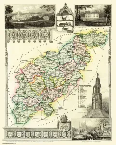
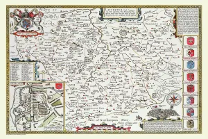
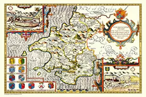
Old County Map of Northamptonshire 1611 by John SpeedA facimile of John Speeds historical map of Northamptonshire originally published for the " Theatre of the Empire of Great Britain"
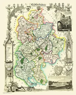
Old County Map of Bedfordshire 1836 by Thomas MouleThis is a fine decorative reproduction County Map of Bedfordshire from the First Edition series of Thomas Moule Maps, originally Published in 1836
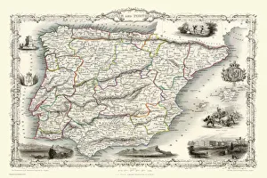
Spain & Portugal 1851A fine facimile artworked from an antique original map of Spain and Portugal, issued as part of the 1851 edition of John Tallis and Companys " The Illustrated Atlas
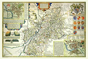
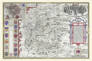
OldCounty Map of Wiltshire 1611 by John SpeedA facimile of John Speeds historical map of Wiltshire published for the " Theatre of the Empire of Great Britain", an atlas to accompany " a history of Great Britain"
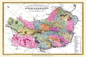
Old County Map of Kurkcudbright Scotland 1847 by A&C BlackA finely detailed facimile remastered in full colour from an antique original map of Kurkcudbright featured in A&C Blacks Atlas of 1847
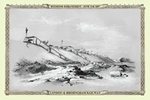
Views on the London to Birmingham Railway - Boxmoor Embankment 1837VR0008
Old Map of the World 1945WMY1945
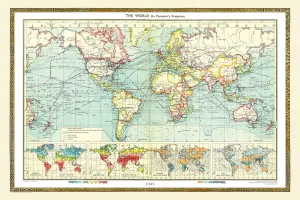
Old Map of the World 1940WMY1940
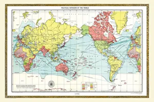
Old Map of the World 1958WMY1958
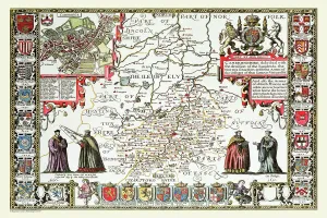
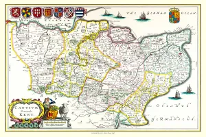
Old County Map of Kent 1611 by John SpeedA facimile of John Speeds historical map of Kent originally published for the " Theatre of the Empire of Great Britain", an atlas to accompany " a history of Great Britain"
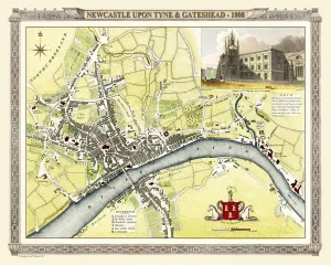
Old Map of Newcastle upon Tyne and Gateshead 1808 by Cole and RoperAn attractive and detailed early 19th century reproduction town plan of Newcastle upon Tyne and Gateshead 1808. First published by Cole and Roper as a finely engraved series of county maps
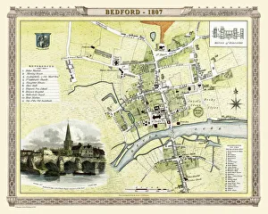
Old Map of Bedford 1807 by Cole and RoperAn attractive and detailed early 19th century reproduction town plan of Bedford, Bedfordshire. First published by Cole and Roper as a finely engraved series of county maps
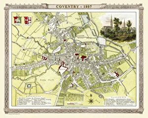
Old Map of Coventry 1807 by Cole and RoperAn attractive and detailed early 19th century reproduction town plan of Coventry 1805. First published by Cole and Roper as a finely engraved series of county maps
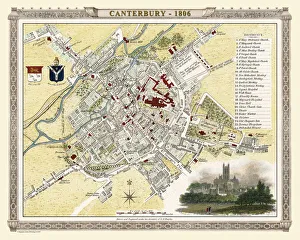
Old Map of Canterbury 1806 by Cole and RoperAn attractive and detailed early 19th century reproduction town plan of Canterbury 1806. First published by Cole and Roper as a finely engraved series of county maps
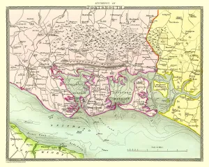
Old Map of the Environs of Portsmouth 1836 by Thomas MouleThis is a fine decorative reproduction Map of The Environs of Portsmouth from the First Edition series of Thomas Moule Maps, originally Published in 1836
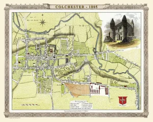
Old Map of Colchester 1805 by Cole and RoperAn attractive and detailed early 19th century reproduction town plan of Colchester 1805. First published by Cole and Roper as a finely engraved series of county maps
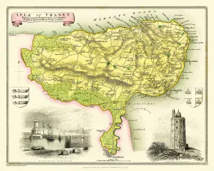
Old Map of The Isle of Thanet 1836 by Thomas MouleThis is a fine decorative reproduction Map of The Isle of Thanet from the First Edition series of Thomas Moule Maps, originally Published in 1836
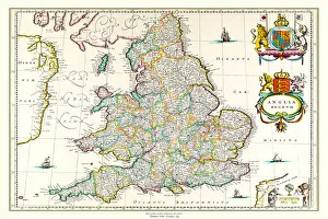
Old Map of England 1635 by Willem & Johan Blaeu from the Theatrum Orbis TerrarumThis detailed and most attractive reproduction map of England has been carefully art worked from a scan of an antique original
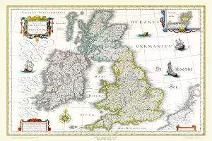
Old Map of The British Isles 1635 by Willem & Johan Blaeu from the Theatrum Orbis TerrarumThis detailed and most attractive reproduction map of The British Isles has been carefully art worked from a scan of an antique original
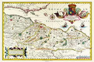
Old Map of Lothian - Scottish Lowlands by Johan Blaeu from the Atlas NovusThis detailed and most attractive reproduction map of the Scottish Lowlands, known as Lothian, has been carefully art worked from a scan of an antique original
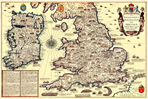
Old Map of The Invasions of England and Ireland by John SpeedA facimile of John Speeds historical map of the Invasions of England and Ireland originally published for the " Theatre of the Empire of Great Britain"
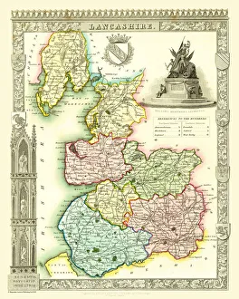
Old County Map of Lancashire 1836 by Thomas MouleThis is a fine decorative reproduction County Map of Lancashire from the First Edition series of Thomas Moule Maps, originally Published in 1836
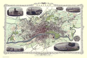
Old Map of Glasgow Scotland 1851 by John TallisThe River Clyde skirts its way through the heart of this famous Scottish City in this wonderful plan by Tallis originally published in 1851. There are six illustrations on the plan
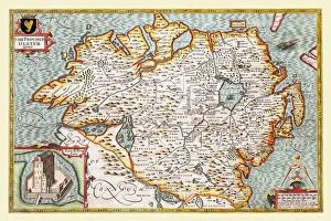
Old Map of The Province of Ulster 1611 by John SpeedA facimile of John Speeds historical map of the Province of Ulster originally published for the " Theatre of the Empire of Great Britain"
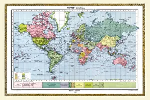
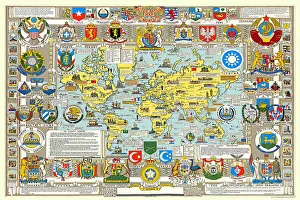
United Nations Map of The World 1948PH006
Old County Map of Kent 1648 by Johan Blaeu from the Atlas NovusThis detailed and most attractive reproduction map of Kent has been carefully art worked from a scan of an antique original
Old County Map of Pembrokeshire, Wales 1611 by John SpeedA facimile of John Speeds historical map of Pembrokeshire originally published for the " Theatre of the Empire of Great Britain"
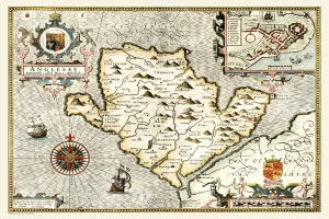
Old Map of The Isle of Anglesey, Wales 1611 by John SpeedA facimile of John Speeds historical map of Anglesey originally published for the " Theatre of the Empire of Great Britain", an atlas to accompany " a history of Great Britain"
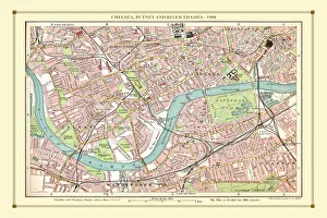
Old Street Map of Chelsea, Putney and River Thames 1908Detailed colour Street Plan of London from 1908 covering the area around Chelsea, Putney and the River Thames. The image has been remastered from Bartholomews Handy Atlas of London and Suburbs 1908
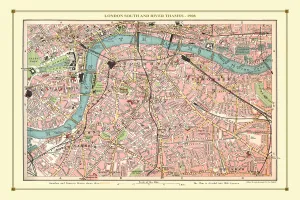
Old Street Map of London South and River Thames 1908Detailed colour Street Plan of London from 1908. The street map features London South wiith the River Thames from Vauxhall Bridge to the London Docks and features Westminster