mail_outline sales@mediastorehouse.com
389 items
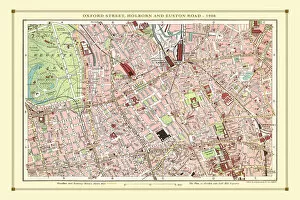
Old Street Map of Oxford Street, Holborn and Euston Road 1908Detailed colour Street Plan of London from 1908 covering the area around Oxford Street, Holborn and Euston Road.The image has been remastered from Bartholomews Handy Atlas of London and Suburbs 1908
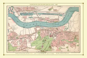
Old Street Map of Woolwich and Thames Docklands 1908Detailed colour Street Plan of London from 1908 covering the area around Woolwich and the Thames Docklands.The image has been remastered from Bartholomews Handy Atlas of London and Suburbs 1908
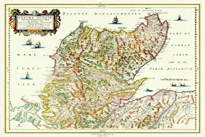
Old Map of Northern Scotland 1654 by Johan Blaeu from the Atlas NovusThis detailed and most attractive reproduction map of Northern Scotland has been carefully art worked from a scan of an antique original
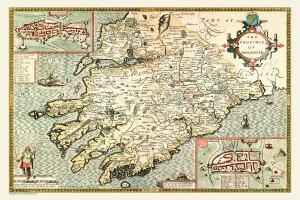
Old Map of The Province of Munster, Ireland 1611 by John SpeedA facimile of John Speeds historical map of the Province of Munster originally published for the " Theatre of the Empire of Great Britain"
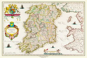
Old Map of Ireland 1635 by Willem & Johan Blaeu from the Theatrum Orbis TerrarumThis detailed and most attractive reproduction map of Ireland has been carefully art worked from a scan of an antique original
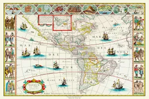
Old Map of The Americas 1635 by Willem & Johan Blaue from the Theatrum Orbis TerrarumThis detailed and most attractive reproduction map of The Americas has been carefully art worked from a scan of an antique original
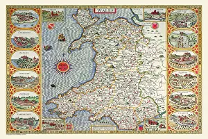
Old Map of Wales 1611 by John SpeedA facimile of John Speeds historical map of Wales originally published for the " Theatre of the Empire of Great Britain", an atlas to accompany " a history of Great Britain"
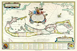
Old Map of The Island of Bermuda 1635 by Willem & Johan Blaue from the Theatrum Orbis TerrarumThis detailed and most attractive reproduction map of The Island of Bermuda has been carefully art worked from a scan of an antique original
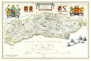
Old County Map of Sussex 1648 by Johan Blaeu from the Atlas NovusThis detailed and most attractive reproduction map of Sussex has been carefully art worked from a scan of an antique original
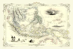
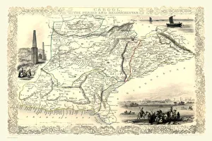
Malay Archipelago, or East India Islands 1851A fine facimile artworked from an antique original map of the Malay Archipelago, or East India Islands, issued as part of the 1851 edition of John Tallis and Companys " The Illustrated Atlas
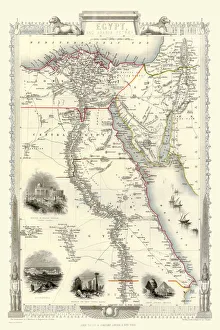
Old Map of Egypt and Arabia Petraea 1851 by John TallisA fine facimile artworked from an antique original map of Egypt and Arabia Petraea, issued as part of the 1851 edition of John Tallis and Companys " The Illustrated Atlas
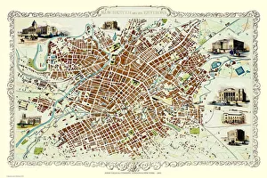
Old Map of Manchester 1851 by John TallisThis John Tallis Victorian map, 1851, of Manchester in Lancashire covers the districts of Salford, Manchester, Ardwick, Chorlton and Hulme
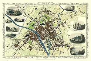
Old Map of York 1851 by John TallisThe River Ouse flows through the famous City of York, already its buildings are spreading outside its ancient walls. The 1851 John Tallis plan is illustrated with views of The Minster, Walmgate Bar
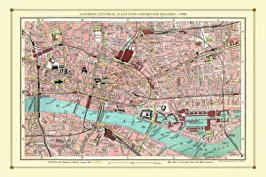
Old Street Map of London Central, East End and River Thames 1908Detailed colour Street Plan of London from 1908. The street map features London Central and the east End with the River Thames from Blackfriars Bridge to the London Docks
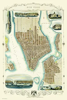
Old Map of New York United States of America 1851 by John TallisThis is a most attractive yet detailed plan 1851 by John Tallis of New York and districts of Jersey, Panovia, Hoboken, Brooklyn and Williamsburgh in the U.S.A
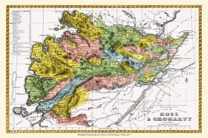
Old County Map of Ross and Cromarty Scotland 1847 by A&C BlackA finely detailed facimile remastered in full colour from an antique original map of Ross and Cromarty featured in A&C Blacks Atlas of 1847
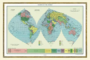
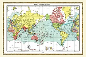
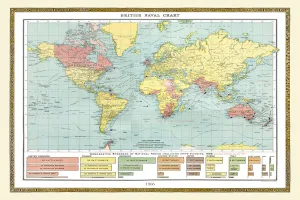
Old Map of the World 1939WMY1939
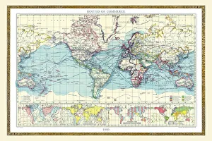
Old Map of the World 1950WMY1950
Old Map of the World 1908WMY1908
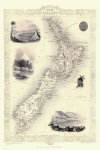
New Zealand 1851A fine facimile artworked from an antique original map of New Zealand, issued as part of the 1851 edition of John Tallis and Companys " The Illustrated Atlas and Modern History of the World"
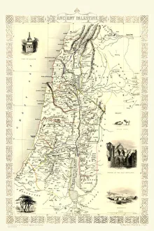
Ancient Palestine 1851A fine facimile artworked from an antique original map of Ancient Palestine, issued as part of the 1851 edition of John Tallis and Companys " The Illustrated Atlas
Early Coastal Survey Map of the Isle of Portsea and Portsmouth Harbour 1716This is a reproduction in colour of the early chart of the Island of Portsea and Portsmouth Harbour. In January 1715/6, in the last stages of the Jacobite emergency, Talbot Edwards
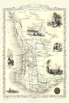
Western Australia and the Swan River 1851A fine facimile artworked from an antique original map of Western Australia and the Swan River, issued as part of the 1851 edition of John Tallis and Companys " The Illustrated Atlas
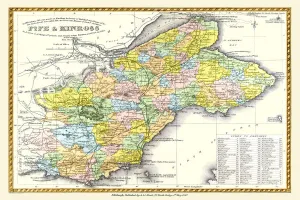
Old County Map of Fife and Kinross Scotland 1847 by A&C BlackA finely detailed facimile remastered in full colour from an antique original map of Fife and Kinross featured in A&C Blacks Atlas of 1847
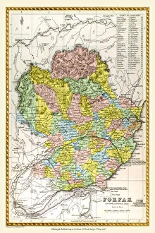
Old County Map of Forfar Scotland 1847 by A&C BlackA finely detailed facimile remastered in full colour from an antique original map of Forfar featured in A&C Blacks Atlas of 1847
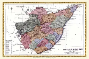
Old County Map of Kincardine Scotland 1847 by A&C BlackA finely detailed facimile remastered in full colour from an antique original map of Kincardine featured in A&C Blacks Atlas of 1847
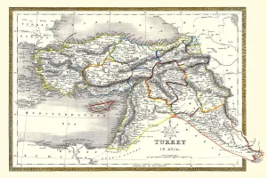
Old Map of Turkey in Asia 1852 by Henry George CollinsThis is a finely detailed map of Turkey in Asia remastered from a rare Atlas of the World published in 1852 by Henry George Collins
Cabool, The Punjab and Beloochistan 1851A fine facimile artworked from an antique original map of Cabool, The Punjab and Beloochistan, issued as part of the 1851 edition of John Tallis and Companys " The Illustrated Atlas
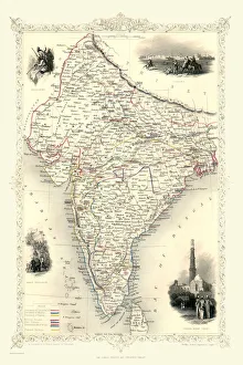
British India 1851A fine facimile artworked from an antique original map of British India, issued as part of the 1851 edition of John Tallis and Companys " The Illustrated Atlas
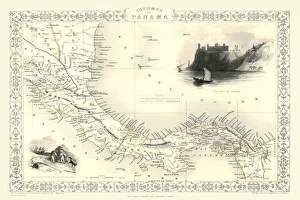
Old Map of Isthmus of Panama 1851 by John TallisA fine facimile artworked from an antique original map of the Isthmus of Panama, issued as part of the 1851 edition of John Tallis and Companys " The Illustrated Atlas
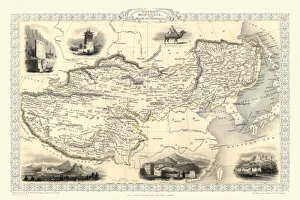
Tibet, Mongolia and Manchuria 1851A fine facimile artworked from an antique original map of Tibet, Mongolia and Manchuria, issued as part of the 1851 edition of John Tallis and Companys " The Illustrated Atlas
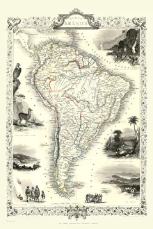
Old Map of South America 1851 by John TallisA fine facimile artworked from an antique original map of South America, issued as part of the 1851 edition of John Tallis and Companys " The Illustrated Atlas
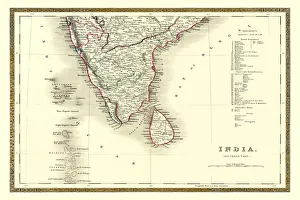
Old Map of Southern India 1852 by Henry George CollinsThis is a finely detailed map of Southern India remastered from a rare Atlas of the World published in 1852 by Henry George Collins
Old Map of the World 1959WMY1959
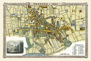
Old Map of Preston 1824 by Edward BainesThis is a fine detailed reproduction Map of The City of Preston from the First Edition series of Thomas Moule Maps, originally Published in 1836
Old Map of the World 1906WMY1906
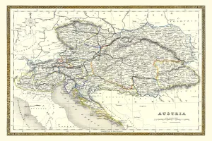
Old Map of Austria 1852 by Henry George CollinsThis is a finely detailed map of Austria remastered from a rare Atlas of the World published in 1852 by Henry George Collins
Old Map of the World 1900WMY1900
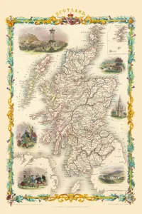
Scotland 1851A fine facimile artworked from an antique original map of Scotland, issued as part of the 1851 edition of John Tallis and Companys " The Illustrated Atlas and Modern History of the World"
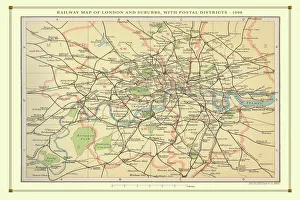
Old Map of the Railways of London and Suburbs 1908 by BartholomewRW0032
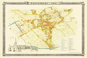
Old Map of Wednesbury Town in the Black Country 1846J023
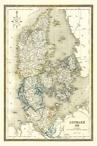
Old Map of Denmark 1852 by Henry George CollinsThis is a finely detailed map of Denmark remastered from a rare Atlas of the World published in 1852 by Henry George Collins
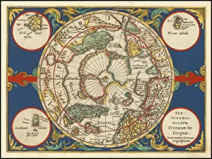
Old Map of The North Pole "Septentrionalium Terrarum descriptio"originally Published by Johannes CloppenburgA striking reproduction from Cloppenburgs reduced size edition of Mercators map of the North Polar regions, the first separate map of the North Polar Regions
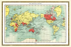
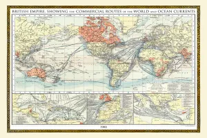
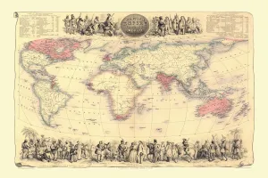
Map of The British Empire by Fullarton & Co 1850Fine reproduction of the attractive World Map showing the British Empire. Mapmaker John Bartholomew and publishers Fullarton were then the first to use red or pink to indicate British possessions
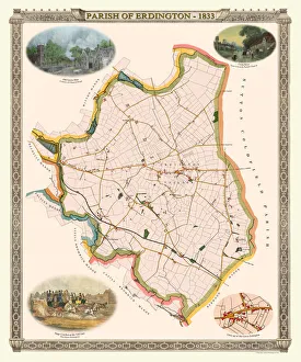
Old Map of The Parish of Erdington 1833J129
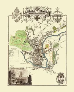
Old Map of the City of Bath 1836 by Thomas MouleThis is a fine decorative reproduction Map of The City of Bath from the First Edition series of Thomas Moule Maps, originally Published in 1836
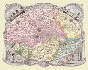
Old Map of the Environs of London 1836 by Thomas MouleThis is a fine decorative reproduction Map of The Environs of London from the First Edition series of Thomas Moule Maps, originally Published in 1836
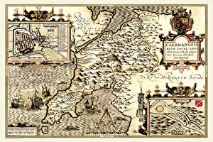
Old County Map of Caernarvonshire, Wales 1611 by John SpeedA facimile of John Speeds historical map of Caernarvonshire originally published for the " Theatre of the Empire of Great Britain"