Home > British Town And City Plans > Irish PORTFOLIO
Photo Mug : Old Map of Belfast 1851 by John Tallis


![]()
Home Decor from MapSeeker
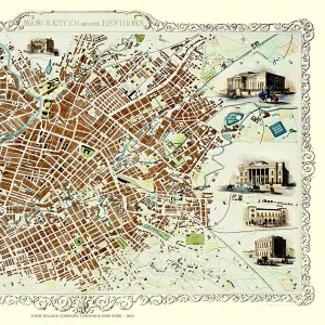
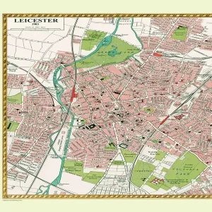
Old Map of Belfast 1851 by John Tallis
The River Lagan dominates the west side of this John Tallis 1851 plan of Belfast with Queens Bridge crossing into the town of Belfast in Northern Ireland. There are six splendid illustrations. These are of Queens College, Ulster Institution for the deaf, dumb and blind, Ulster Railway Station, Ballast Office, and a view across Queens Bridge to Belfast and the Court House
Media ID 20347878
Historic Map John Tallis John Tallis Map Old Town Plan Tallis Map
Photo Mug
A personalised photo mug blends sentimentality with functionality, making an ideal gift for cherished loved ones, close friends, or valued colleagues. Preview may show both sides of the same mug.
Elevate your coffee or tea experience with our premium white ceramic mug. Its wide, comfortable handle makes drinking easy, and you can rely on it to be both microwave and dishwasher safe. Sold in single units, preview may show both sides of the same mug so you can see how the picture wraps around.
Mug Size is 9.5cm high x 8cm diameter (3.7" x 3.1")
These are individually made so all sizes are approximate
MADE IN THE UK
Safe Shipping with 30 Day Money Back Guarantee
FREE PERSONALISATION*
We are proud to offer a range of customisation features including Personalised Captions, Color Filters and Picture Zoom Tools
SECURE PAYMENTS
We happily accept a wide range of payment options so you can pay for the things you need in the way that is most convenient for you
* Options may vary by product and licensing agreement. Zoomed Pictures can be adjusted in the Cart.