Home > British Town And City Plans > Irish PORTFOLIO
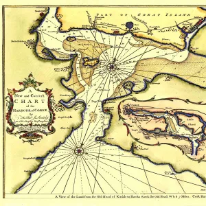
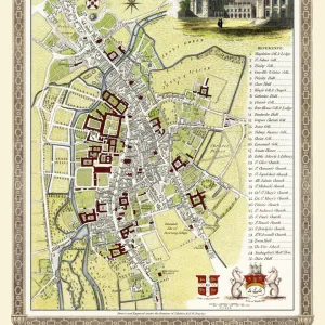
Old Map of Cork Ireland 1851 by John Tallis

![]()
Wall Art and Photo Gifts from MapSeeker
Old Map of Cork Ireland 1851 by John Tallis
In this Victorian map of Cork in southern Ireland by John Tallis the North and South channels of the River Lee flow through the centre of the plan with the extensive Barracks dominating the northeast. There are four picturesque views of Cork. These views are of Black Rock Castle, Queenstown Harbour Cove of Cork, Old Weir Bridge Killarney and Blarney Castle
Media ID 20347886
Historic Map John Tallis John Tallis Map Old Town Plan Tallis Map
MADE IN THE UK
Safe Shipping with 30 Day Money Back Guarantee
FREE PERSONALISATION*
We are proud to offer a range of customisation features including Personalised Captions, Color Filters and Picture Zoom Tools
SECURE PAYMENTS
We happily accept a wide range of payment options so you can pay for the things you need in the way that is most convenient for you
* Options may vary by product and licensing agreement. Zoomed Pictures can be adjusted in the Basket.