Framed Print > Maps from the British Isles > Scotland and Counties PORTFOLIO
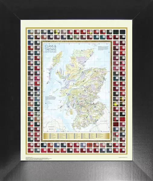
Framed Print : Map of the Clans and Tartans of Scotland


![]()
Framed Photos from MapSeeker
Map of the Clans and Tartans of Scotland
This map of Scotland indicates the general sphere of influence held by the clans and considerable families at the beginning of the 17th century. Some clans and families held small areas of land, and if their names are not on this map, they were not necessarily landless. The areas representing the ancient Principalities of Scotland are indicated on the map. Scotland has a rich and enduring culture steeped in history. One of the most distinctive features, of which are probably that of clanship and the predominantly Highland clans. Highland dress and the tartan is a powerful symbol of the wearerAEs pride in a Scottish ancestry and in Scotland itself. There are few, if any, other forms of national dress which can claim to make such a clear and unequivocal statement, and to be so instantly and widely recognisable
Media ID 20348040
12"x10" Modern Frame
10x8 Print in an MDF Wooden Frame with 180 gsm Satin Finish Paper. Glazed using shatter proof thin plexi glass. Frame thickness is 1 inch and depth 0.75 inch. Fluted cardboard backing held with clips. Supplied ready to hang with sawtooth hanger and rubber bumpers. Spot clean with a damp cloth. Packaged foam wrapped in a card.
Contemporary Framed and Mounted Prints - Professionally Made and Ready to Hang
Estimated Image Size (if not cropped) is 25.4cm x 25.4cm (10" x 10")
Estimated Product Size is 25.4cm x 30.5cm (10" x 12")
These are individually made so all sizes are approximate
Artwork printed orientated as per the preview above, with landscape (horizontal) or portrait (vertical) orientation to match the source image.
MADE IN THE USA
Safe Shipping with 30 Day Money Back Guarantee
FREE PERSONALISATION*
We are proud to offer a range of customisation features including Personalised Captions, Color Filters and Picture Zoom Tools
SECURE PAYMENTS
We happily accept a wide range of payment options so you can pay for the things you need in the way that is most convenient for you
* Options may vary by product and licensing agreement. Zoomed Pictures can be adjusted in the Cart.