Poster Print > Maps from the British Isles > Scotland and Counties PORTFOLIO
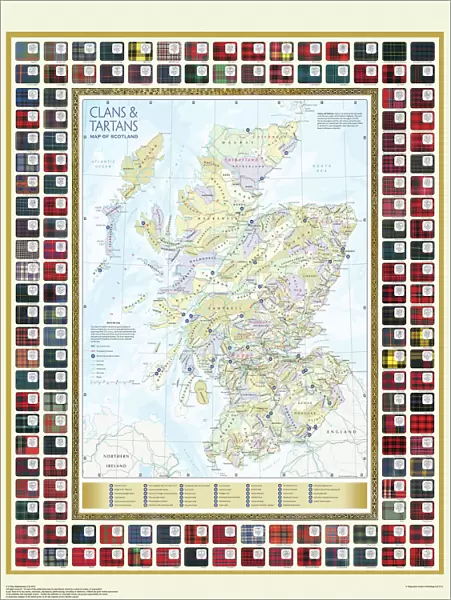
Poster Print : Map of the Clans and Tartans of Scotland

![]()
Poster Prints from MapSeeker
Map of the Clans and Tartans of Scotland
This map of Scotland indicates the general sphere of influence held by the clans and considerable families at the beginning of the 17th century. Some clans and families held small areas of land, and if their names are not on this map, they were not necessarily landless. The areas representing the ancient Principalities of Scotland are indicated on the map. Scotland has a rich and enduring culture steeped in history. One of the most distinctive features, of which are probably that of clanship and the predominantly Highland clans. Highland dress and the tartan is a powerful symbol of the wearerAEs pride in a Scottish ancestry and in Scotland itself. There are few, if any, other forms of national dress which can claim to make such a clear and unequivocal statement, and to be so instantly and widely recognisable
Media ID 20348040
18x24 inch Poster Print
Poster prints are budget friendly enlarged prints in standard poster paper sizes. Printed on 150 gsm Matte Paper for a natural feel and supplied rolled in a tube. Great for framing and should last many years. To clean wipe with a microfiber, non-abrasive cloth or napkin. Our Archival Quality Photo Prints and Fine Art Paper Prints are printed on higher quality paper and the choice of which largely depends on your budget.
Poster prints are budget friendly enlarged prints in standard poster paper sizes (A0, A1, A2, A3 etc). Whilst poster paper is sometimes thinner and less durable than our other paper types, they are still ok for framing and should last many years. Our Archival Quality Photo Prints and Fine Art Paper Prints are printed on higher quality paper and the choice of which largely depends on your budget.
Estimated Product Size is 46.3cm x 61.6cm (18.2" x 24.3")
These are individually made so all sizes are approximate
Artwork printed orientated as per the preview above, with portrait (vertical) orientation to match the source image.
MADE IN THE USA
Safe Shipping with 30 Day Money Back Guarantee
FREE PERSONALISATION*
We are proud to offer a range of customisation features including Personalised Captions, Color Filters and Picture Zoom Tools
SECURE PAYMENTS
We happily accept a wide range of payment options so you can pay for the things you need in the way that is most convenient for you
* Options may vary by product and licensing agreement. Zoomed Pictures can be adjusted in the Cart.