Metal Print > Maps from the British Isles > Scotland and Counties PORTFOLIO
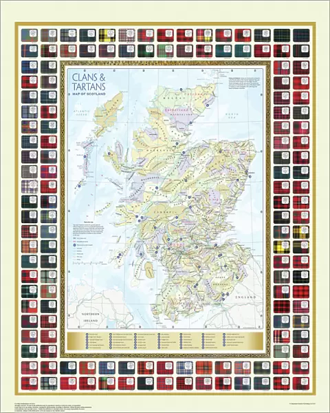
Metal Print : Map of the Clans and Tartans of Scotland

![]()
Metal Prints from MapSeeker
Map of the Clans and Tartans of Scotland
This map of Scotland indicates the general sphere of influence held by the clans and considerable families at the beginning of the 17th century. Some clans and families held small areas of land, and if their names are not on this map, they were not necessarily landless. The areas representing the ancient Principalities of Scotland are indicated on the map. Scotland has a rich and enduring culture steeped in history. One of the most distinctive features, of which are probably that of clanship and the predominantly Highland clans. Highland dress and the tartan is a powerful symbol of the wearerAEs pride in a Scottish ancestry and in Scotland itself. There are few, if any, other forms of national dress which can claim to make such a clear and unequivocal statement, and to be so instantly and widely recognisable
Media ID 20348040
16"x20" (51x41cm) Metal Print
Made with durable metal and luxurious printing techniques, our metal photo prints go beyond traditional canvases, adding a cool, modern touch to your space. Wall mount on back. Eco-friendly 100% post-consumer recycled ChromaLuxe aluminum surface. The thickness of the print is 0.045". Featuring a Scratch-resistant surface and Rounded corners. Backing hangers are attached to the back of the print and float the print 1/2-inch off the wall when hung, the choice of hanger may vary depending on size and International orders will come with Float Mount hangers only. Finished with a brilliant white high gloss surface for unsurpassed detail and vibrance. Printed using Dye-Sublimation and for best care we recommend a non-ammonia glass cleaner, water, or isopropyl (rubbing) alcohol to prevent harming the print surface. We recommend using a clean, lint-free cloth to wipe off the print. The ultra-hard surface is scratch-resistant, waterproof and weatherproof. Avoid direct sunlight exposure.
Made with durable metal and luxurious printing techniques, metal prints bring images to life and add a modern touch to any space
Estimated Image Size (if not cropped) is 40.6cm x 50.8cm (16" x 20")
Estimated Product Size is 41.2cm x 51.4cm (16.2" x 20.2")
These are individually made so all sizes are approximate
Artwork printed orientated as per the preview above, with portrait (vertical) orientation to match the source image.
MADE IN THE USA
Safe Shipping with 30 Day Money Back Guarantee
FREE PERSONALISATION*
We are proud to offer a range of customisation features including Personalised Captions, Color Filters and Picture Zoom Tools
SECURE PAYMENTS
We happily accept a wide range of payment options so you can pay for the things you need in the way that is most convenient for you
* Options may vary by product and licensing agreement. Zoomed Pictures can be adjusted in the Cart.