Photographic Print > Maps from the British Isles > Scotland and Counties PORTFOLIO
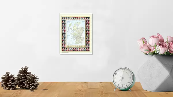
Photographic Print : Map of the Clans and Tartans of Scotland

![]()
Photo Prints from MapSeeker
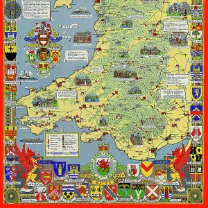
Map of the Clans and Tartans of Scotland
This map of Scotland indicates the general sphere of influence held by the clans and considerable families at the beginning of the 17th century. Some clans and families held small areas of land, and if their names are not on this map, they were not necessarily landless. The areas representing the ancient Principalities of Scotland are indicated on the map. Scotland has a rich and enduring culture steeped in history. One of the most distinctive features, of which are probably that of clanship and the predominantly Highland clans. Highland dress and the tartan is a powerful symbol of the wearerAEs pride in a Scottish ancestry and in Scotland itself. There are few, if any, other forms of national dress which can claim to make such a clear and unequivocal statement, and to be so instantly and widely recognisable
Media ID 20348040
10"x8" Photo Print
Photo prints are produced on Kodak professional photo paper resulting in timeless and breath-taking prints which are also ideal for framing. The colors produced are rich and vivid, with accurate blacks and pristine whites, resulting in prints that are truly timeless and magnificent. Whether you're looking to display your prints in your home, office, or gallery, our range of photographic prints are sure to impress. Dimensions refers to the size of the paper in inches.
Our Photo Prints are in a large range of sizes and are printed on Archival Quality Paper for excellent colour reproduction and longevity. They are ideal for framing (our Framed Prints use these) at a reasonable cost. Alternatives include cheaper Poster Prints and higher quality Fine Art Paper, the choice of which is largely dependant on your budget.
Estimated Product Size is 20.3cm x 25.4cm (8" x 10")
These are individually made so all sizes are approximate
Artwork printed orientated as per the preview above, with portrait (vertical) orientation to match the source image.
MADE IN THE USA
Safe Shipping with 30 Day Money Back Guarantee
FREE PERSONALISATION*
We are proud to offer a range of customisation features including Personalised Captions, Color Filters and Picture Zoom Tools
SECURE PAYMENTS
We happily accept a wide range of payment options so you can pay for the things you need in the way that is most convenient for you
* Options may vary by product and licensing agreement. Zoomed Pictures can be adjusted in the Cart.