Poster Print > British Town And City Plans > English & Welsh PORTFOLIO
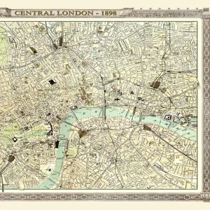
Poster Print : Old Map of London 1851 by John Tallis

![]()
Poster Prints from MapSeeker
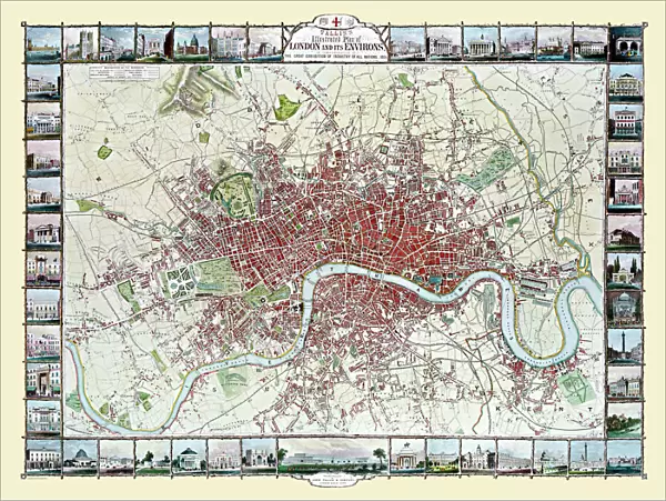
Old Map of London 1851 by John Tallis
Commemorating the Great Exhibition of Industry of All Nations 1851, this magnificent plan of London, re-created and art worked directly from the antique original, is elegantly framed by 49 individual views of Londons historic buildings and monuments. The plan is incredibly detailed considering the large area it captures. Surrounded by countryside, to the north - west is Cricklewood and Hampstead, to the north east is Lowe Leyton and Leyton Stowe. To the south west is Fulham and to the south east the Isle of Dogs and Greenwich. Among the many historic buildings and monuments illustrated are the Houses of Parliament, Westminster Abbey, St Pauls Cathedral, Tower of London, Buckingham Palace and the grand Crystal Palace built for the great exhibition of Industry of all nations held in London
Media ID 20348248
Historic Map John Tallis John Tallis Map London Map Map Of London Old Town Plan Tallis Map
18x24 inch Poster Print
Poster prints are budget friendly enlarged prints in standard poster paper sizes. Printed on 150 gsm Matte Paper for a natural feel and supplied rolled in a tube. Great for framing and should last many years. To clean wipe with a microfiber, non-abrasive cloth or napkin. Our Archival Quality Photo Prints and Fine Art Paper Prints are printed on higher quality paper and the choice of which largely depends on your budget.
Poster prints are budget friendly enlarged prints in standard poster paper sizes (A0, A1, A2, A3 etc). Whilst poster paper is sometimes thinner and less durable than our other paper types, they are still ok for framing and should last many years. Our Archival Quality Photo Prints and Fine Art Paper Prints are printed on higher quality paper and the choice of which largely depends on your budget.
Estimated Product Size is 61.6cm x 46.3cm (24.3" x 18.2")
These are individually made so all sizes are approximate
Artwork printed orientated as per the preview above, with landscape (horizontal) orientation to match the source image.
MADE IN THE USA
Safe Shipping with 30 Day Money Back Guarantee
FREE PERSONALISATION*
We are proud to offer a range of customisation features including Personalised Captions, Color Filters and Picture Zoom Tools
SECURE PAYMENTS
We happily accept a wide range of payment options so you can pay for the things you need in the way that is most convenient for you
* Options may vary by product and licensing agreement. Zoomed Pictures can be adjusted in the Cart.