Home > British Town And City Plans > English & Welsh PORTFOLIO
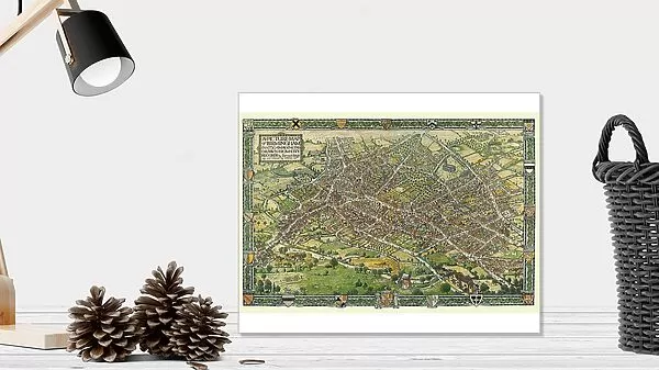
Photographic Print : A Conjectural Picture Map of Birmingham In 1730

![]()
Photo Prints from MapSeeker
A Conjectural Picture Map of Birmingham In 1730
This is a striking colourful picture map of Birmingham in 1730, originally imagined & drawn from city records by Bernard Sleigh and lettered by I.A. Ellis, 1923. Originally printed by the Kynoch Press A.D. 1924, and published by Cornish Bros. Limited 39 New Street. This is a wonderfully detailed colourful pictorial map showing roads, the river Rea, principal buildings and the many dwellings, artisans workshops at a time when Birmingham rural aspect was about to transform into an industrial town rapidly growing outwards consuming the then far off villages that now form part of what is now the countries second city
Media ID 20347731
10"x8" (25x20cm) Photo Print
Printed on archival quality paper for unrivalled stable artwork permanence and brilliant colour reproduction with accurate colour rendition and smooth tones. Printed on professional 234gsm Fujifilm Crystal Archive DP II paper. 10x8 for landscape images, 8x10 for portrait images.
Our Photo Prints are in a large range of sizes and are printed on Archival Quality Paper for excellent colour reproduction and longevity. They are ideal for framing (our Framed Prints use these) at a reasonable cost. Alternatives include cheaper Poster Prints and higher quality Fine Art Paper, the choice of which is largely dependant on your budget.
Estimated Image Size (if not cropped) is 25.4cm x 16.9cm (10" x 6.7")
Estimated Product Size is 25.4cm x 20.3cm (10" x 8")
These are individually made so all sizes are approximate
Artwork printed orientated as per the preview above, with landscape (horizontal) orientation to match the source image.
FEATURES IN THESE COLLECTIONS
> British Town And City Plans
> English & Welsh PORTFOLIO
> Pictorial Maps and Pictorial History
MADE IN THE UK
Safe Shipping with 30 Day Money Back Guarantee
FREE PERSONALISATION*
We are proud to offer a range of customisation features including Personalised Captions, Color Filters and Picture Zoom Tools
SECURE PAYMENTS
We happily accept a wide range of payment options so you can pay for the things you need in the way that is most convenient for you
* Options may vary by product and licensing agreement. Zoomed Pictures can be adjusted in the Cart.